 
Mikem
Member
Username: Mikem
Post Number: 1430
Registered: 10-2003
Posted From: 68.43.12.165
| | Posted on Sunday, April 24, 2005 - 11:26 pm: |    |
A Detroit expressway and transit plan, prepared back in 1945 for the Detroit Transportation Board, has come into my hands. It was commissioned by the board to plan for future transportation needs in the city after the war. The study is 40 pages of maps, tables, and artist’s sketches, and the consulting engineers’ recommendations, divided into two main sections: Detroit Expressway System and Detroit Transit System. I know there are a few of you interested in mass transportation issues, the role of the expressway in Detroit’s growth and decline, and Detroit history buffs. I’ll share a bit of this here for those of you interested in such things.
After an introductory section the document starts off summarizing their recommendations for expressways in Detroit:
quote: Expressways should provide three lanes of pavement for mixed traffic in each direction, with all intersecting streets bridged or connected with flanking service roads. The separated express roadways should be depressed where possible with gentle slopes between the service roads and the central pavement landscaped to include promenades, walks and bicycle paths. Rights-of-way should be adequate for these facilities. Playgrounds, ranging in size from recreation areas for small children to athletic fields for boys and girls, and neighborhood parks for older people should be included as marginal improvements.
There is immediate need for an expressway running from Southfield Road in the northwest section into the heart of the business district to relieve the present congestion on Grand River. This expressway should follow Grand River from Southfield to Wyoming, then bend south around the eastern edge of the industrial district into Michigan (which would be widened to include the expressway) and then proceed to Vernor which also would be widened to a junction with the John C. Lodge Expressway.
The John C. Lodge Expressway should be laid down on the route already planned by the Wayne County Road Commission, from Grand Boulevard south to Jefferson.
The Hastings Expressway should be constructed from Jefferson to the Six-Mile Road, generally skirting the west edge of the industrial district it would parallel.
The short but vital section of Vernor between Lodge and Hastings and extending east to a connection with Gratiot should be built to form one of the first-needed three sides of a downtown traffic quadrangle.
The Crosstown should follow the route projected by the State Highway Department from the west city line at Michigan across the city beyond Gratiot.
An expressway spur should be built along Connor for a mile south from the Crosstown to Warren.
An expressway connection should be made from the Crosstown to Mound, where it now deadends.
They cover a bit of financing details:
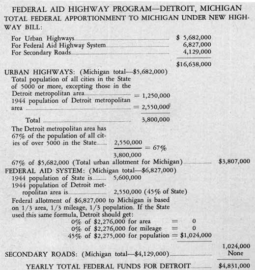
quote: Designed to meet federal requirements for interregional expressways with provision for adequate rights-of-way and incidental improvements, this program is estimated to cost $131,400,000, exclusive of the cost of rapid transit features. In our opinion, the seven projects would be eligible for aid under the new federal highway law. Under this program the State of Michigan is entitled to $16,638,000 per year. The City of Detroit is entitled to $4,831,000 of this amount of federal aid per year under the intent and letter of the federal highway act. The present agreement between the state, county and city authorities to supplement federal aid for expressways provides for almost exactly the annual participation needed; the state to contribute $3,000,000 and the county and city $1,500,000 each. Federal aid, the State’s share and an amount equal to the States share contributed by Wayne County and the City of Detroit (each paying one-half of the State amount) adds up to almost $11,000,000 to be available each year for the first three years of postwar construction. On the assumption that the highway program would continue beyond the present three-year authorization period at the same pace (which we believe is a reasonable expectation), funds would be available from the following sources to pay for the whole program: federal 44%, state 28%, county 14% and city 14% . In any event, yearly quotas of funds are in sight at a rate to complete enough of the program to be useful.
Of course at this time, only the Davison and the Detroit Industrial Freeway existed. Here are some of the various plans for expansion:
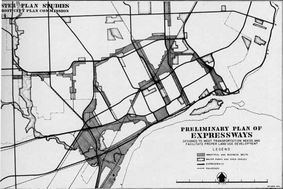
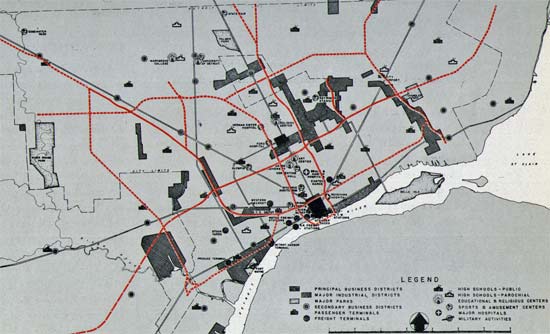
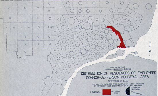
From the City of Detroit’s 1944 Master Plan, showing expressways in relation to industrial areas of the city.
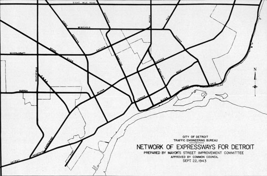
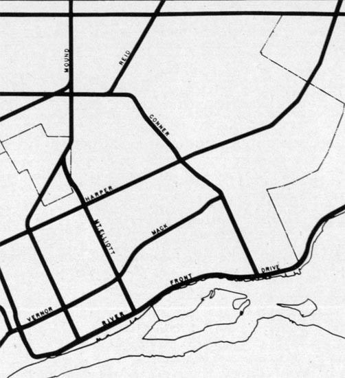
Here’s a plan from the mayor’s “Street Improvement Committee” in 1943 with two close-ups following. What they had in mind with the term “expressway”, I’m not sure.
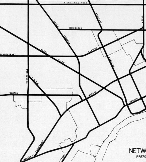
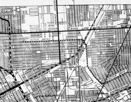
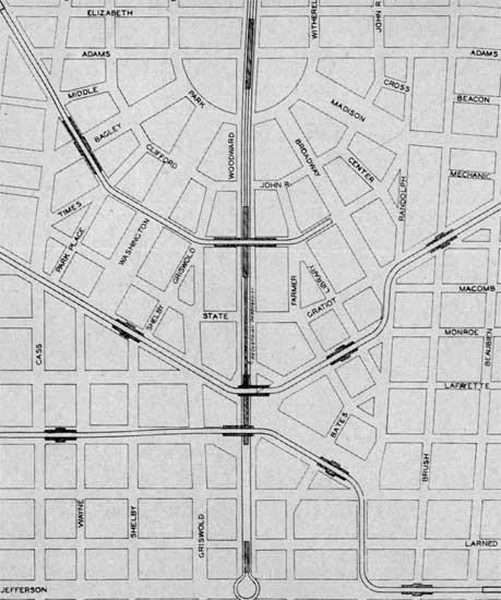
Wayne County Road Commission plans for Detroit, 1944.
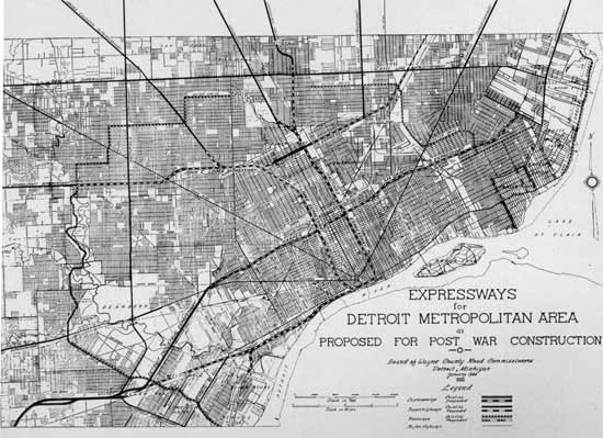
Hard to read, I know. I-94 was the "Harper-McGraw Expressway", I-75 the "Hastings Expressway", and the solid lines are the existing main arteries with the added designation of "Superhighway", i.e., Mack Superhighway", "Mound Superhighway", "Schoolcraft Superhighway", etc.
Here are some details:
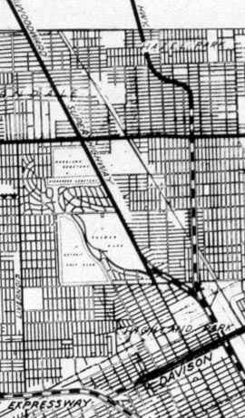
The Hastings Expressway would connect with the Stephenson Superhighway north of the Eight Mile Superhighway, and also have a spur leading to the Woodward Superhighway near McNichols:
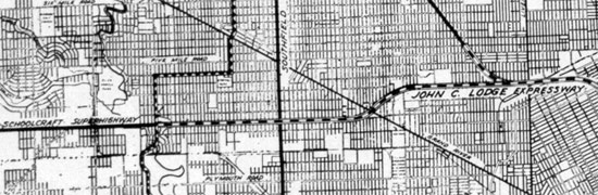
The John C Lodge Expressway would connect to the Schoolcraft Superhighway west of Grand River, and have a spur leading to the James Couzens Superhighway.
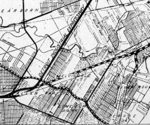
An unamed Expressway would lead from downtown to the Detroit Industrial Expressway through Melvindale, with a spur sothward to connect with West Jefferson at the Rouge River.
The Davison would extend east to the west side of the Grand Trunk RR and then parallel it northeastward into Macomb Co. (not to be confused with Grosbeck Highway).
 |
Mikem
Member
Username: Mikem
Post Number: 1432
Registered: 10-2003
Posted From: 68.43.12.165
| | Posted on Sunday, April 24, 2005 - 11:56 pm: | |
They give some background to the developement of the city's street pattern and the need to fix itse traffic jams and smooth the traffic flow:
quote:The expressway system in Detroit must be laid down over the existing street pattern and a brief review of how the city grew in shape helps explain where traffic arteries are needed now. The downtown business core of the City of Detroit took its shape from ‘The Governor and Judges’ Plan” which was developed in 1806 when the population was only 1500. This provided for 200-foot wide avenues, spaced at intervals of 4,000 feet north and south and at intervals of 2,000 feet east and west. The quadrants formed by these avenues were to be connected by major and secondary diagonal boulevards. Uncontrolled subdivisions and real estate developments soon scrambled the city plan which was started so boldly, but short sections of streets survived to stake down the hub of the city into its present location. In 1830 Governor Cass laid down five military roads, each 100 feet wide, which became permanent spokes from the downtown hub. A generation later under authority of the Michigan Plank Road Act, there was a general expansion of road building which added to the radials. The Grand Boulevard was charted around the then city limits another generation later in 1877. The “Governor and Judges’ Plan,” the five military roads of Governor Cass with their additions and the construction of the Grand Boulevard form the skeleton of the street system of Detroit.
As the city became older the rectangular section system was superimposed over the strong radials for new streets as they were built. The newer sections, generally beyond the 5-mile circle, fell into the pattern of the mile-square sections.
The City Charter of 1918 created the City Plan Commission. In cooperation with the Detroit Rapid Transit Commission and in collaboration with the Road Commissions of Wayne, Oakland and Macomb Counties and the authorities of the municipalities within the metropolitan area, it adopted a master plan of thoroughfares by 1926. This master plan provided that section line roads be 120 feet wide, half-mile section and quarter-mile section arteries be 86 feet wide and intermediate streets 60 feet wide. It also mapped the 204-feet-wide superhighways, extending generally from 6 miles from the downtown hub to a 15 mile circle. These new arteries with wide rights-of-way did not reach down into the crowded streets from which their roots sprung. Even with the widening of radial avenues in recent years, the major traffic improvements did not reach far into the city.
The present streets of Detroit and its environs consist of wide boulevards and adequate avenues on the outskirts of the city but like other cities the core is congested and choked with traffic.
The arterial vehicular traffic jams in Detroit can be cleared only by breaking the bottlenecks in the heart of the city where the greatest volume occurs. Traffic studies clearly show that a large percentage of traffic proceeds between its origin and destination on illogical routes. The crow-foot avenues, the confused tangle of the old city, the rectangular pattern of the newer developments, the network of railroads, the absence of breaks in topography through which arteries might have been built behind the growth of the city, the monotonous flatness downtown which prompted the solid building with no open spaces between developments, the relation of business and industry to the waterfront; all these contribute to the circuitous travel necessary to reach most points by automobile. The streets of Detroit are wider than those in most cities hut they arc not wide enough in the right places and cannot he stretched enough at most throats of congestion to meet the increasing traffic loads. The greatest barriers to convenient and safe automobile travel are the automobiles themselves which were built faster than the streets were modernized to accommodate them.
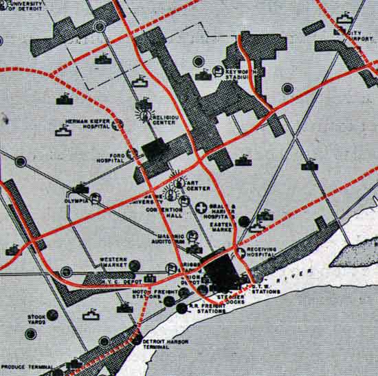
The locations of the principal business districts, secondary business sections, industrial and manufacturing areas, railroads and terminals, educational institutions, recreation centers, hospitals and other features of community development influenced our conclusions in selecting the routes for the combined expressway and transit system. The character of the buildings on the proposed rights-of-way and the effects of replacing them with the proposed improvements were important considerations, particularly the influence on the neighborhoods. The effect of the improvements on desirable future community development and on the stabilization of manufacturing and business areas and residential neighborhoods along the routes and in the areas served by them has prompted many of our decisions.
With no natural open spaces to follow, the new expressways must be located largely through solid development. It is fortunate that the general pattern of traffic flow coincides with belts of depressed property cheap enough to acquire for wide traffic arteries.
"Existing industries would benefit by better routes between work and homes and trucking materials would be cheaper and faster:"
"Business districts, educational institutions, recreation centers, hospitals and other community developments would be served by the expressways:"
 |
Jjaba
Member
Username: Jjaba
Post Number: 1662
Registered: 11-2003
Posted From: 24.21.101.214
| | Posted on Sunday, April 24, 2005 - 11:59 pm: | |
jjaba likes the free interchange of "the Six Mile Road" with "Mc Nichols." The same street has two names inside of Detroit, according to them. When did the name change anyway?
jjaba still prefers Davison "Ditch." It was built 1944. About the same time, the Aroyo Seco Expressway was built in LA County, Calif. It has another name too. Can you guess?
Excellent post MikeM. You're amazing.
jjaba |
East_detroit
Member
Username: East_detroit
Post Number: 278
Registered: 11-2003
Posted From: 69.212.169.194
| | Posted on Monday, April 25, 2005 - 12:13 am: | |
Wow, there was a Western Market (as well as Eastern Market)?
What happened to it? Is it still there?
Also, what happened to Keyworth Stadium? |
Mikem
Member
Username: Mikem
Post Number: 1433
Registered: 10-2003
Posted From: 68.43.12.165
| | Posted on Monday, April 25, 2005 - 12:18 am: | |
And a Central Market and a Broadway(?) Market.
Keyworth is still there. |
Jjaba
Member
Username: Jjaba
Post Number: 1665
Registered: 11-2003
Posted From: 24.21.101.214
| | Posted on Monday, April 25, 2005 - 12:18 am: | |
Western Market was on W. Michigan Avenue next door to the Hygrades Hot Dog Ballpark Frank plant.
jjaba, Westsider |
Leland_palmer
Member
Username: Leland_palmer
Post Number: 131
Registered: 08-2004
Posted From: 69.246.99.22
| | Posted on Monday, April 25, 2005 - 12:24 am: | |
Great info, please keep posting. |
Mikem
Member
Username: Mikem
Post Number: 1434
Registered: 10-2003
Posted From: 68.43.12.165
| | Posted on Monday, April 25, 2005 - 12:31 am: | |
I scanned the plan and converted it to text. Here it is in .doc form but I had to break it into several parts for posting limitations. It's missing a few tables that didn't convert well and I'll post those later.
|
Mikem
Member
Username: Mikem
Post Number: 1435
Registered: 10-2003
Posted From: 68.43.12.165
| | Posted on Monday, April 25, 2005 - 1:27 am: | |
Something screwed up with that last post and I can't edit it either for some reason, so if you have trouble opening them email me at kc8ttv@comcast.net and I'll send you the whole thing.
quote:SEVEN EXPRESSWAY PROJECTS
A number of public agencies have made studies for expressways in Detroit and some of their plans have official status. The City Council has adopted the Mayor’s Street Improvement Committee’s long-term plan for a network of expressways. The City Plan Commission has recommended a somewhat different system. The City Engineer has developed plans in considerable detail on at least one route. The Wayne County Road Commission has studied expressway routes and is welt advanced in the detailed design of one expressway. In recent years it successfully constructed a limited access highway with flanking service roads through the city of Highland Park. The Michigan State Highway Department has built the Detroit Industrial Expressway from the Willow Run war plant to the west boundary of the city at Michigan. Its continuation through the city to be known as the Crosstown is being laid out now.
The routes which we recommend are not original with us. While none appears on all of the plans, each one has been proposed by one or more of the local agencies. We have added some new features and recommended some deviations from the routes previously plotted, but on the whole our system represents the selection from many routes of the seven following projects which we believe could be built in twelve years at the rate funds now seems to be in sight.
Grand River Expressway
The proposed section of Grand River Expressway from Southfield Road to the John C. Lodge Expressway is 9.9 miles long. Beginning at the northwest end, the first mile should constitute a widening of Grand River on the south side providing express roadways flanked by service drives on each side. Part of the present Grand River would become the north service road. The line then would swing south around a small business district in the vicinity of Greenfield but return to Grand River which would he expanded as before to Meyers. Between Meyers and Wyoming the proposed right-of-way parallels Grand River a short block away to the south, leaving a frontage of thriving businesses on both sides of the existing street. From Wyoming the expressway would swerve south from Grand River, paralleling the railroad through the blocks to Joy. Then it would occupy the full blocks between Epworth and Colfax, Wesson and North Campbell and swing diagonally into Michigan Avenue, which would be widened on the north side with the expressway located between two service roads. The expressway would continue to John C. Lodge through widening of Vernor.
We have examined a number of plans for the relief of traffic on Grand River. The network of expressways for Detroit prepared by the Mayor’s Street Improvement Committee and approved by the Common Council on September 22, 1943 indicates a route along the entire length of this artery. The City Engineer’s office has been engaged for some time in developing a detailed study of a route on or paralleling the existing street. The route which we recommend follows both plans from Southfield to Wyoming, but bends south away from Grand River because we do not believe the lower section of this artery should be widened or an expressway pushed through the type of development in this section. The route recommended would improve and protect values of adjacent property rather than depress existing values. Along a considerable distance, it would serve as a buffer between the railroad and industries on the side and residential areas on the other. It would avoid the need of three intricate interchanges of expressway traffic between Grand River, John C. Lodge and Vernor Expressways within a small triangle of expensive downtown area which never could be developed logically in such a tangle of ramps. It would substitute for this a simpler interchange which would tend to feed traffic more evenly into the Vernor and John C. Lodge sides of the downtown loop.
The route would serve the growing population to the northwest and pass by or near industrial areas in the Michigan-Livernois section employing 40,000 people. It would tap the Michigan Central Railroad Station and the Briggs Stadium also. A dual purpose would be served in providing an improved entrance for both Grand River and Michigan traffic to the downtown area. Through much of its length it would take land in substandard areas where there is acute need for the incidental improvements to the expressway. Upon consideration of all factors, we find this is the better route for the Grand River Expressway.
John C. Lodge Expressway
Our recommendation for John C. Lodge Expressway follows the plans already in preparation by the Wayne County Road Commission. This express way would form the downtown traffic quadrangle together with Jefferson, Hastings and Vernor. North of Vernor the right-of-way would lay the backbone for the rehabilitation of a neighborhood that badly needs it. The alignment has been judiciously planned to fit in with the layout of the proposed Jeffries housing project. Additional incidental improvements recommended include playground and recreation fields for the public housing and the schools and the local area in general, which would improve the neighborhood through which this expressway passes. In conjunction with the Grand River Expressway, it also would help to meet any remaining traffic problem on the section of Grand River not included in our present expressway program. This 3.3 mile long section would terminate for the present with a -grade-crossing elimination at Grand Boulevard. In the future it would be extended north and northwest to Davison Expressway, James Couzens and Northwest Highway, Grand River and Schoolcraft. This north extension of John C. Lodge is shown on our map along Hamilton. Consideration was given to an alternate route along 12th Street which has merit, especially from the standpoint of community and neighborhood development. Right-of-way and construction costs are in favor of the Hamilton route, but the exact selection is a close decision and should be reexamined when construction on this future section is scheduled.
Hastings Expressway
The Hastings Expressway also would pass through substandard areas and would act as a separation between residential sections to the west and the industrial area to the east. The City Plan Commission’s line follows generally the route which we finally selected, although there is little difference between that plan and the one developed by Wayne County except at the south end. This route would lend itself particularly to the development of incidental improvements badly needed in connection with neighborhood rehabilitation. Acquisition of the right-of-way actually would constitute a slum clearance project for much of its 6.8 miles of length and construction of the expressway would invite and justify private development of wide scope along it. It also would tap the extensive Eastern Market. These are in addition to its primary functions as an extremely important traffic relief artery to overloaded Woodward Avenue and a feeder to a belt of adjacent industries. Future extension from the six-mile road north would be necessary.
Vernor Expressway
The Vernor Expressway as shown on our plan is a direct extension of Grand River Expressway and would form the north side of the downtown traffic quadrangle 1.6 miles long. High property costs, the nature of the adjacent property and the layout of the abutting street systems would necessitate a narrower right-of-way which would require much of the depressed expressway to be built with walls supporting the service roads. In the future this expressway could be extended east to a connection with the Conner Expressway and Mack Highway.
Crosstown Expressway
The Crosstown Expressway has been laid down to follow the lines developed by the Michigan State Highway Department. The need for this improvement along the McGraw-Harper route has been realized for a long time. All the expressway programs which we examined include this improvement. There is only one comparatively minor difference in alignment between the proposals of various agencies which occurs where the route crosses Warren. We believe that the north route in this section is more desirable than one following McGraw, primarily because this expressway is designed to carry rapid transit in the central mall and there is more room on the north route to accomplish it. The transit features requiring wider right-of-way will necessitate other adjustments and changes in location, but the general route across the city is properly fixed. The 12-year program would provide for carrying the Crosstown for 10 miles as far east as Conner; after that it could be extended northeast.
Conner Expressway Spur
The first mile of the Conner Expressway between Harper and Warren should be built in order to accommodate the rapid transit service in the central mall. In future years this expressway should continue to Jefferson along the indicated route which would swing to the east of Conner at the south end. This whole route is important but only one mile of it could be financed in the 12-year program.
Mound Expressway Connection
The Crosstown should be connected to Mound with an expressway to tap the industries in this section and form a strong connection with the north traffic. The exact route which we suggest does not follow the lines of any previous proposals which we have examined, but we believe it is a cheaper and a more practical location.
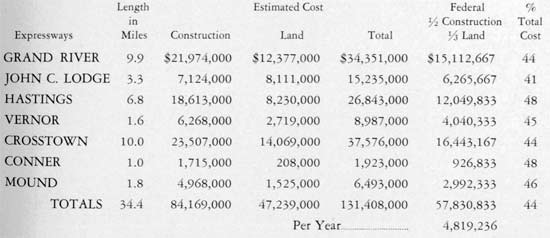
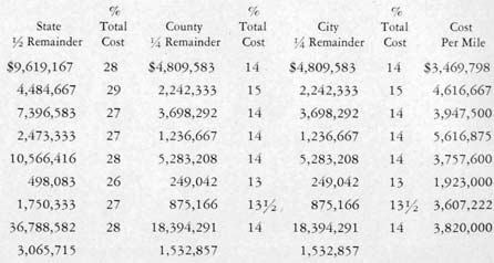
TOTAL EXPRESSWAY COST FOR 12-YEAR PROGRAM
The Detroit expressways in this program total 34.4 miles in length and are estimated to cost $131,400,000 based on present day building prices and the assessed values for private property required for right-of-way. This is an average of $1,373,000 per mile for land and $2,447,000 per mile for construction, or $3,820,000 per mile for all costs including incidental and marginal improvements.
Under the new Federal Aid Highway law, Michigan should be entitled to $16,638,000 per year for the three-year program. It is our opinion that the city should be allocated $4,831,000 per year of this amount. The following formula expresses our interpretation of the proper distribution on the basis of present population:
The City has already worked out an agreement with Wayne County and the State to contribute $1,500,000 per year matched by $1,500,000 of county funds and $3,000,000 of state funds for expressway construction. This total of $6,000,000 per year is contingent upon an equal amount of federal aid. This agreement was devised before the federal aid bill was passed but requires only minor modification to be applied to this program. There would be no changes in the agreed amounts.
The federal highway law limits federal contributions to one-half for construction on each project, exclusive of right-of-way costs of which the federal government’s share is restricted to one-third. The maximum federal aid has been computed for each project in this program for both construction and right-of-way cost and the net result is that the Public Roads Administration can only contribute 44% towards the whole $131,400,000 program. This would require twelve years of federal aid under the present legal formula and authorization to complete the program. The remaining costs of each project apportioned on the city, county, and state ratio of matching would provide the rest of the funds in almost the exact amounts needed to carry out the schedule of constructing the expressways.
More precise estimates of costs and sharing of expense are outlined in the following table:
DETROIT EXPRESSWAY SYSTEM - 12 YEAR COST ALLOCATION
(Message edited by MikeM on April 25, 2005) |
Hornwrecker
Member
Username: Hornwrecker
Post Number: 12
Registered: 04-2005
Posted From: 67.192.63.108
| | Posted on Monday, April 25, 2005 - 1:29 am: | |
My 1930ish map of Detroit shows an Industrial Super Highway in a dashed line. It branches off of Hoover, just North of Eight Mile, paralleling and just West of Grosbeck.
I remember my father talking about a freeway up Mound connecting to the Davison {somewhere}. He was correct about the eventual 11 Mile Road Freeway, that I first heard about in the mid 60s. I'm still trying to figure out why the Davison was never connected to I-96... I never heard about the Conner/McNichols to Couzens one, maybe Outer Drive built up too fast. Who knows? |
Jsmyers
Member
Username: Jsmyers
Post Number: 709
Registered: 12-2003
Posted From: 141.211.251.154
| | Posted on Monday, April 25, 2005 - 1:37 am: | |
"Between Meyers and Wyoming the proposed right-of-way parallels Grand River a short block away to the south, leaving a frontage of thriving businesses on both sides of the existing street."
Sure, thriving businesses...
http://www.terraserver.microso ft.com/image.aspx?T=4&S=9&Z=17 &X=3241&Y=46927&W=3&qs=%7cdetr oit%7cmi
I know that isn't the section in question, but it is the same theory, and it didn't work... |
Hornwrecker
Member
Username: Hornwrecker
Post Number: 13
Registered: 04-2005
Posted From: 67.192.63.108
| | Posted on Monday, April 25, 2005 - 1:47 am: | |
I don't know if this is true, but wasn't Hastings the main drag through "Black Bottom". You put together whatever the reasons, to level that area, are during that period of time.
/spreading rumors |
Jsmyers
Member
Username: Jsmyers
Post Number: 710
Registered: 12-2003
Posted From: 141.211.251.154
| | Posted on Monday, April 25, 2005 - 1:50 am: | |
I don't think that is a very contentious assertion.
But it was called black bottom hundreds of years ago because of the dark low soil, not the people who came later. |
Mikem
Member
Username: Mikem
Post Number: 1437
Registered: 10-2003
Posted From: 68.43.12.165
| | Posted on Monday, April 25, 2005 - 2:00 am: | |
Hey kids, get the hell out of the street!
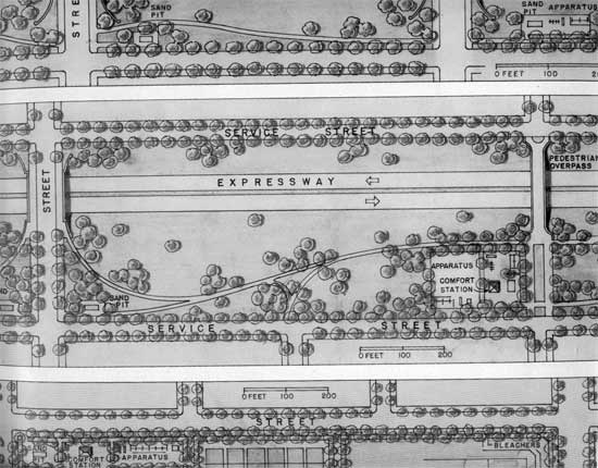
"Play areas within the expressway rights-of-way could be reached from both sides of the improvements over bridges and pedestrian overpasses. Mothers could watch their own children in resting areas near play apparatus:"
 |
Hornwrecker
Member
Username: Hornwrecker
Post Number: 14
Registered: 04-2005
Posted From: 67.192.63.108
| | Posted on Monday, April 25, 2005 - 2:04 am: | |
True for the reason, but it was where all the hot jazz clubs were, and the main black cultural area then.
Thanks Mikem for the info. I just wish some of the roads that were built, or planned actually connected logically {and were straighter}.
I remember when I-75 ended at Eight Mile for what seemed the longest time, and when it started going North in another county, it took a meandering course. I wonder what the politics of it were back then; imagine I-75 without all of the right angle turns, and how much quicker your commutes would be now... and don't get me started with those walkway things over I-696, and why they were built for many millions. |
Jsmyers
Member
Username: Jsmyers
Post Number: 711
Registered: 12-2003
Posted From: 141.211.251.154
| | Posted on Monday, April 25, 2005 - 2:08 am: | |
That just doesn't make a bit of since to me!
The design speed of freeways (maybe not urban ones) back for decades was often 80-85 mph. (Ever notice that most curves on the freeway still are comfortable up to that speed?)
A car going even 60 makes a lot of noise.
Especially when it is big ol' american iron with a V8.
Had this actually been built, Detroit would have had a huge public health crisis from all of the lead-poisoned (form leaded gas), hard of hearing kids.
What were they thinking? |
Mikem
Member
Username: Mikem
Post Number: 1438
Registered: 10-2003
Posted From: 68.43.12.165
| | Posted on Monday, April 25, 2005 - 2:13 am: | |
Crooked raods bothering you? Well there's a very good reason for it!
quote:FEATURES OF AN EXPRESSWAY
Locating an expressway boils down to defining its characteristics and shape, fixing its cross-section dimensions and adjusting its location as closely as possible to the most direct and heaviest traveled lanes, at a reasonable cost and with the greatest benefit to the neighborhoods it touches. Directness of travel sometimes costs more than it is worth. Bends in alignment often are more desirable than blasting through an established neighborhood. Increased length and somewhat more circuitous routing may tap and serve industries, businesses and homes which do not lie in the path of a straight road. Also the straight road may be there first and its existence may force by-passing to avoid disrupting an established community. Genuine, large-scale slum clearance to let in sunlight and air can be accomplished by opening up wide arteries and often can be hitched to an expressway project by going just a little out of the way at an inconsequential time loss. The expressway can be made to serve as a protective buffer between industries and adjacent residential areas. Many obstacles can be avoided or overcome by careful design but every route runs sooner or later into something in its path where it must be decided whether or not to take it, skip it or look somewhere else. Most obstructions are usually large and easy to see and appraise. Big and valuable buildings, irreplaceable parks, industries impractical to penetrate, compact neighborhoods too expensive to acquire, long stretches of going businesses, major utilities and awkward terrain can be measured promptly. The toughest part of the job of locating an expressway through a city usually crops up after the project has been running smoothly in the right place through rundown property or over vacant land and then, without warning, the line creeps into a different kind of district where the improvement does not belong. There are no slide-rules to solve this problem. Finding the proper location for an expressway with its incidental improvements requires analysis of authoritative traffic flow investigations, but the human and economic factors are equally important.
Also, these weren't going to be just freeways; I haven't gotten to the mass transit part yet:
 |
Mikem
Member
Username: Mikem
Post Number: 1439
Registered: 10-2003
Posted From: 68.43.12.165
| | Posted on Monday, April 25, 2005 - 2:30 am: | |
How do you get off the train in the middle of the road?
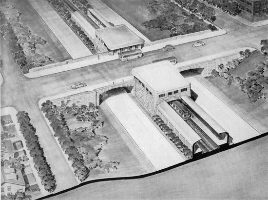
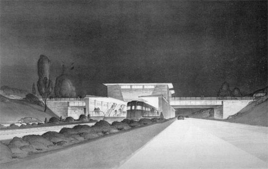
"Rail rapid transit stations on the expressways would be designed as part of the masonry-faced bridges. Passengers from the streets and buses above would reach covered car platforms through these stations:"
 |
Lowell
Board Administrator
Username: Lowell
Post Number: 1181
Registered: 10-2003
Posted From: 66.167.212.185
| | Posted on Monday, April 25, 2005 - 2:32 am: | |
My, my what a chapter in the destruction of Detroit. I felt mayself say Nooo, stopppp!
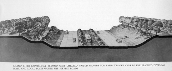
It is interesting that they didn't get all the expressways they wanted, but they got enough. The above picture of the Grand River Expressway with rail in the center is reminscent of Chicago. Too bad. So close.
I also enjoyed the 'what about the children' aspect and the mention of playgrounds where they could breathe all those nicely leaded fumes.
Tragi-comic. Another great presentation MikeM. Thanks. |
Mikem
Member
Username: Mikem
Post Number: 1440
Registered: 10-2003
Posted From: 68.43.12.165
| | Posted on Monday, April 25, 2005 - 2:39 am: | |
Where's the graffitti? The billboards? The hubcaps? The signs? The streetlights? Even I could sell you a freeway if it were really like this.
"The expressway transit stations at steel bridges would harmonize with the architecture of these spans:"
 |
Rrl
Member
Username: Rrl
Post Number: 291
Registered: 12-2003
Posted From: 67.184.183.177
| | Posted on Monday, April 25, 2005 - 2:45 am: | |
Maybe someone should send a copy of this to L.Brooks. Rather than widening I-75, perhaps it should be built as originally intended, with mass transit down the median.
Good stuff MikeM |
Hornwrecker
Member
Username: Hornwrecker
Post Number: 15
Registered: 04-2005
Posted From: 67.192.63.108
| | Posted on Monday, April 25, 2005 - 2:49 am: | |
My brother just asked me the following:
Ask if anyone remembers the TV cameras that were on the Lodge back in
the late 50's They were mounted on overpasses In big metal boxes with
fences all around them. Of course back then it was all tube electronics. Where were they controlled from and what was the purpose
of it? I wonder if it was some kind of GM experiment. I think there
were even signs on them saying TV.
Anybody remember these thingees? |
Jjaba
Member
Username: Jjaba
Post Number: 1666
Registered: 11-2003
Posted From: 24.21.101.214
| | Posted on Monday, April 25, 2005 - 4:00 am: | |
The black boxes on the John C. Lodge Expressway flashed speed limit numbers. If you maintained 35 MPH, as it told you, traffic would move smoothly. That was the idea after they discovered so many cars had moved from surface to expressways going downtown on the first big expressway. jjaba rode it often in a ride down to Cass Tech., shortly after opening in the period 1956-59.
Lowell is right. Chicago's Dan Ryan, Eisenhower, and JFK Expressways have "L" train lines in the center median. You access the stops from overhead bridges and walk down ramps to the trains. These lines are not integrated well into neighborhoods and the stops are terribly windy, noisy, hot or very cold as they are out in the weather in the center of traffic. However, the trains move fast and there was minimum destruction to existing city. Downtown, the trains enter the State or Dearborn Street subways. Both Chicago airports have train service inside the terminals with one-seat service to downtown.
The new Red Line MAX Airport service in Portland, Oregon runs on two expressways from Downtown to PDX. In downtown, the MAX trains run on city streets like streecars and share with cars. The idea here is the integration of travel with window shopping, not possible in a subway set-up.
Los Angeles also has rails in the center of freeways. BART in Bay Area runs like that also.
jjaba |
Jerome81
Member
Username: Jerome81
Post Number: 560
Registered: 11-2003
Posted From: 66.245.57.3
| | Posted on Monday, April 25, 2005 - 4:08 am: | |
If only we could take it all back, know then what we know now.
Expressways ruin neighborhoods. Its as simple as that. Even if they looked like they do in the drawings, they'd still bisect the landscape, and that is where the real damage lies.
Having that mass transit to go with it would have been much preferred, however.
I can't stand to see this stuff sometimes. And on top of that, I'm amazed how so much of the rhetoric of back then is the same today. "Congestion means we need more and wider roads!" They blabbed it then, and even though we now better now that it is the other way around, people still blab the same, the rest of us agree, and money is spent, only for those same roads to become congested again.
Congestion is a sign of health. Ever been to a world class city that WASN'T congested? I haven't. I'm not sure they exist.
And the other thing that cracks me up is the claim that shipping will be faster and cheaper. I wonder how that holds today. My guess is it isn't any faster shipping something from highland park to dearborn on the freeways than it was when they used Oakman Blvd. Only now we have the giant life sucking monstrosities instead of just another road.
Sometimes American history leaves me feeling so sad. I think oftentimes if freeways were never built (or at least kept to simply connecting cities across long distances, not the inter-urban freeways) and the government wouldn't have subsidized loans for greenfield single family home construction, and didn't continue doing that to this day, we'd all be a whole lot better off. Economically, socially, and environmentally.
I hope we can change. But sometimes you just wanna say "F it, it is what it is, just go along for the ride". Depressing sometimes. |
623kraw
Member
Username: 623kraw
Post Number: 619
Registered: 10-2003
Posted From: 68.41.224.200
| | Posted on Monday, April 25, 2005 - 4:59 am: | |
If one looks down Mound Rd. travelling south from 13 mile, the Ren Cen can clearly be seen. A proposed x-way that never existed from Warren to downtown has been talked about since the '60's it seems; straight shot...10 minutes |
Mikem
Member
Username: Mikem
Post Number: 1441
Registered: 10-2003
Posted From: 68.43.12.165
| | Posted on Monday, April 25, 2005 - 12:44 pm: | |
Hey, hey, don't be comming down on our infrastructure! Time is money, and every minute saved gets passed on in the form of cheaper goods and services. Look at the distribution of workers throughout our city:
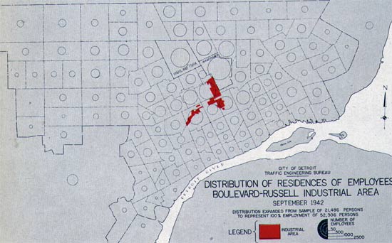
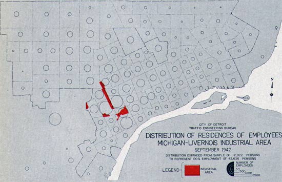
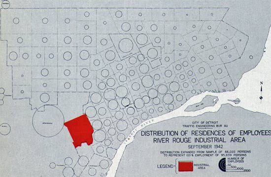
As you can see, many workers in these industrial corridors have to travel across town. Just think of how much more productive they could be if we rescued them from traffic jams and saved gasoline in the process:
 |
Missnmich
Member
Username: Missnmich
Post Number: 273
Registered: 11-2004
Posted From: 70.186.23.6
| | Posted on Monday, April 25, 2005 - 1:23 pm: | |
Can you imagine how much more land those marginal playgounds would have taken?
I remember crying as a child watching houses and trees demolished in Detroit, Lansing, and Cleveland in the name of progress.
Aside to JJABA: Pasadena Freeway. |
Jjaba
Member
Username: Jjaba
Post Number: 1667
Registered: 11-2003
Posted From: 24.21.101.214
| | Posted on Monday, April 25, 2005 - 1:39 pm: | |
Oh boy. So why did they choose these corners as destinations?
City Hall no longer exists. Today, you can take any expressway and never find it.
Woodward-Manchester is Ford Highland Park Plant. Gone.
2nd Ave. and W. Grand Blvd. GM Hdq. gone. (Replaced by the Welfare Dept.) Retail dead.
Can you tell us why they picked the corners on the Eastside? Or do I have to plough through MikeM's wonderful maps with the circles and arrows, and all the fineprint?
Great work Mike. After Ali, you're the greatest.
jjaba, Westsider |
Goat
Member
Username: Goat
Post Number: 5862
Registered: 10-2003
Posted From: 65.92.102.119
| | Posted on Monday, April 25, 2005 - 1:55 pm: | |
At least T.O. Got part of their highway done correctly. The mass transit in the middle of the highway makes good sense. If only in Detroit...
Thanks for so much info folks! |
Dan
Member
Username: Dan
Post Number: 805
Registered: 10-2003
Posted From: 68.43.18.209
| | Posted on Monday, April 25, 2005 - 2:03 pm: | |
WOW. What a great thread.
Thanks Mikem!
These are conversations that keep me coming back. |
Jjaba
Member
Username: Jjaba
Post Number: 1670
Registered: 11-2003
Posted From: 24.21.101.214
| | Posted on Monday, April 25, 2005 - 2:24 pm: | |
Goat, jjaba can't recall if Canada uses freeway medians for rapid transit. The idea is efficient for land and not very good of building neighborhoods.
For example, in Portland, Oregon, the Gateway rail station is located quite far from the retail and out by the I-205 Freeway. Passengers with strollers, shopping bags, and all manner of other assorted hauls, and the wheel-car set, have long walks. Other stations like Parkrose and Hollywood are as bad.
Older systems have trains running up alleys, or on surface corridors closer to where people need them. The NY subway delivers passengers inside of buildings, old and new alike. The new Dallas system delivers passengers inside the 7-11 headquarters. It is slick. Freeway mass-transit doesn't come close.
A terrible example of this is White Sox-35th St. Station after a ballgame. After a game, drunken fans have to squeeze in through narrow doors, down some escalators or steps, and onto platforms out on the Dan Ryan Expressway where racing cars are damn closeby. To mitigate the tumult, the CTA does sell return tkts. to arriving passengers BEFORE the game to ease congestion later.
Atlanta, Chicago, Portland (Ore.), St. Louis, San Francisco, Cleveland and Philadelphia all have trains inside airport terminals. It almost feels like London or Rome.
AND THEN THERE'S DETROIT!
jjaba on the Dexter bus. |
Detroitnerd
Member
Username: Detroitnerd
Post Number: 434
Registered: 07-2004
Posted From: 209.69.221.253
| | Posted on Monday, April 25, 2005 - 7:00 pm: | |
The Main Library's map division has a copy of the 1951 Master Plan with large-form color charts, including those fanciful Westside highways. An illuminating read for those with time to blow. |
Mikem
Member
Username: Mikem
Post Number: 1445
Registered: 10-2003
Posted From: 68.43.12.165
| | Posted on Monday, April 25, 2005 - 7:33 pm: | |
On to the transit system. The background and need for an improved mass transit system:
quote:The history of public transportation in Detroit reveals that street car lines were established by a number of competing companies all seeking to reach the most profitable areas. No logical pattern of routes could come out of this competitive growth, and the bus lines established in recent years have not been able to compensate for the original lack of planning. Many bus and street car lines are slow, and some follow circuitous routes. A number of the existing transit lines compete with one another over a substantial portion of their length. In some cases car lines were paralleled by bus lines during a prewar program of conversion from rail to rubber-tired vehicles. This program was unavoidably stopped by wartime freezing of all programs of this nature.
The lines now operated serve the central business district primarily. Before the war, 14 of the 20 rail lines, and 22 of the 44 bus lines passed through or terminated in this area. Largely because of this basic characteristic of the system, only 20 to 30 percent of workers in the important outlying industrial plants were users of transit facilities, while nearly 70 percent of the people accumulated in the downtown area at the peak traveled on public carriers, as determined by a 1936 survey.
Equipment on many lines is not appropriate to the volume and type of traffic served. For example, small gasoline buses are used in normal times on the Grand River Coach route, which is a heavy trunk line, while large street cars are used on the relatively light St. Jean crosstown line. Detroit has none of the large gasoline, diesel, or trolley buses and no P.C.C. cars or other modern transit vehicles which have proved popular and efficient in many other large cities.
Destinations within the city required as much as an hour and a quarter to reach by public transportation, starting in the central business district during rush hours, even in the prewar period when express buses were operated. Although rapid transit facilities have been proposed for Detroit periodically over the past two decades, the city is still without a system of fast carriers comparable to those found in most other large cities.
The need for improved public transportation is clear. In spite of the high percentage of car owners, a large proportion of the population uses buses and street cars. For example, of all the people in the downtown area in mid-afternoon on an average weekday in 1943, more than 73 percent had entered the area in public carriers. In 1942-1943, the average Detroiter took 217 rides per year on the Department of Street Railways system.
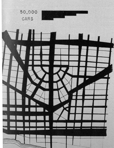
A graph of the number and method of commuters into the CBD (Sixth, Vernor, Hastings, River) during a typical weekday. Hour of day on the bottom, thousands of passengers on the left. The cut-off curve on the top is the combined total of auto and transit passengers, and tops out at just under 100,000 at 2:15 PM.
"Accumulation of Persons in the Central Business District Shown by Mode of Transportation:"
 |
The_aram
Member
Username: The_aram
Post Number: 3270
Registered: 10-2003
Posted From: 68.43.31.87
| | Posted on Monday, April 25, 2005 - 7:33 pm: | |
This is an incredibly fascinating thread. Thank you, MikeM. You just provided me some serious reading material when my last final exam is over tomorrow afternoon.
On a quick glance, I noticed "River Front Dr." on one of the maps. Was this a planned road that never happened? Or some kind of adaptation to Jefferson? |
Mikem
Member
Username: Mikem
Post Number: 1446
Registered: 10-2003
Posted From: 68.43.12.165
| | Posted on Monday, April 25, 2005 - 7:36 pm: | |
I figured it was the Expressway version of Jefferson, but maybe it would have been Atwater instead? |
The_aram
Member
Username: The_aram
Post Number: 3271
Registered: 10-2003
Posted From: 68.43.31.87
| | Posted on Monday, April 25, 2005 - 7:38 pm: | |
Yeah, it literally hugs the river, a lot more than Jefferson does from my recollection. I don't know what the appeal of a freeway directly on the riverfront would be, but I guess that's probably why it didn't happen. |
Mikem
Member
Username: Mikem
Post Number: 1447
Registered: 10-2003
Posted From: 68.43.12.165
| | Posted on Monday, April 25, 2005 - 8:22 pm: | |
quote:TRANSIT ROUTES
Crosstown Rapid Transit
This essential crosstown trunk line, first proposed in 1926, has been included in every proposal for rapid transit development during subsequent years. The line would meet a long-felt need for fast transportation between Detroit’s east and west sections. Connecting with essentially every north-south bus line as well as with the Woodward, Grand River and Gratiot services, it would be used by a substantial portion of all transit patrons.
The route would start in a terminal station under Miller connected directly to the Ford River Rouge plant by means of pedestrian passageways. This station would have three platforms so that inbound and outbound passengers could be segregated. Such an arrangement not only would provide greater convenience for passengers but also would increase capacity in rush hours by reducing the turn-around time and headway of trains.
It is proposed to use the existing structure at Eagle Place under the Rougemere Railroad yard. Swinging north, the route would traverse clay pits and undeveloped areas over low-cost right-of-way. Appropriate landscaping would improve this section. Connections would be made to the existing Department of Street Railways yards at Wyoming and Michigan, and these existing terminal facilities would be arranged for storage and servicing of rapid transit trains.
Tracks would be carried in a long underpass beneath Michigan Avenue and under the eastbound roadway of the Crosstown Expressway. Then they would emerge in the broad central mall of the expressway and follow that route as far as Conner and Warren.
At this point, the rapid transit tracks would connect to a modern, ballasted, elevated roadbed above Conner Lane through the heart of the Conner-Mack industrial area. Stations at intersections with transit routes also would be convenient to large plants. Connections are proposed to the Shoemaker-St. Jean yards, and the project would include the conversion of some existing storage and shop facilities necessary to service the rapid transit equipment.
The tracks would descend from elevated to subway between Kercheval and Jefferson. Swinging easterly in Jefferson, the route would serve the Conner-Jefferson industrial area with a three-platform station at Conner similar to the station at the west terminal. The total length of line would be 14 miles. The average speed of trains would be 25 miles per hour.
This trunkline railroad, interlacing the network of local routes, and affording efficient crosstown travel heretofore lacking, would provide the most essential service not available now. Stations would be built at the following locations:
| Ford | Trumbull | Van Dyke | | Michigan | Second-Third | Gratiot | | Central | Woodward | St. Jean | | Livernois | Hastings | Warren E. | | Warren W. | St. Aubin | Mack | | Grand Blvd. W. | Chene | Vernor | | Grand River | Mt. Elliott | Conner | | Fourteenth |
This route, built as a subway, would cost approximately $74,000,000 at present day prices. By adjusting the alignment to use the center mall of the Crosstown Expressway throughout most of its length, this rapid transit route could be completed for $35,800,000 thus effecting a saving of more than $38,000,000.
Woodward Route
The Woodward line will form the north-south backbone of the transit system. Stemming from the central business district, its passengers would branch out on the various east-west routes to almost every part of central Detroit.
A common route for the north-south expressway and the transit line would have been ideal. The best location for the expressway, and the one recommended in this report, lies approximately one-half mile east of Woodward and is thus in a location unsuited to the needs of a transit route.
Another route was investigated for a combined facility approximately one block east of Woodward. Both expressway and transit line lost too many of their advantages to compromise on such a route.
Consideration was given to the proposal that the right-of-way of the Grand Trunk Western be utilized as a major trunkline transit route extending north and south throughout Detroit. The location of this right-of-way, a mile east of Woodward Avenue, is unsuitable for such a purpose.
The only feasible solution under this program, therefore, would be to provide modern street car operation from a downtown terminal subway portal at Adelaide, and north along Woodward on the surface as an initial step.
Stations on the downtown subway section are planned at:
Jefferson
Cadillac Square
Grand River
Adams
Vernor
Grand River Rapid Transit
The location of the 1.1 mile long expressway adjacent to Grand River Avenue northwest of West Chicago would provide an opportunity to install a completely grade-separated, two-track railroad in the center mall at a reasonable cost. Street cars would operate from the center mall tracks near West Chicago to the existing surface car tracks in Grand River Avenue and then into a terminal dip on Grand River Avenue from Second to Woodward.
Street cars operating from a terminal at Southfield would furnish rapid transit service to West Chicago and Grand River, and local service from there to a portal at First. The project would include new storage yards and shops in the vicinity of Southfield and Grand River.
The length of this route would be subdivided as follows: terminal subway, 0.6 miles; Grand River Avenue local service, 4.4 miles; Grand River Rapid Transit, 4.3 miles; West Chicago subway 0.7 miles; total length, 10.0 miles. Rush hour speeds would be more than 18 miles per hour. Stations on the rapid transit section of this route are planned at the following locations:
| Livernois | Schoolcraft | | Plymouth | Greenfield | | Wyoming | Woodmont | | Meyers | Southfield-Fenkell | | Schaefer |
A supplementary bus route is proposed which would provide local service along the service drives of the Grand River Expressway from the city limits to West Chicago. At this point buses would leave the local drives and operate at expressway speed over the grade-separated roadways, returning to the surface street system at Woodward and Vernor. The downtown route would furnish local service along Woodward.
The average scheduled speed in the express section of this run would be over 25 miles per hour. Stops would be made to pick up and discharge passengers at the following locations:
Livernois
Tireman
Crosstown
Grand
Fourteenth
Trumbull
Gratiot Rapid Transit
With the expressway improvements, the 90-foot pavement on Gratiot would have sufficient capacity for both private vehicles and public carriers, particularly with the car tracks and safety islands removed and replaced by a center mall.
People driving automobiles from the downtown areas to points near Gratiot beyond the Crosstown Expressway would save time by following the Hastings and Crosstown Expressways to Gratiot. A similar advantage for transit patrons is proposed through the operation of express buses along this same route. The downtown surface terminal of this route is planned at Wood-ward and Cadillac Square, affording transfer connections with the five routes converging in the central underground plaza at this location. Proceeding east at street grade, lines would follow access drives into the Hastings Expressway. They would turn east on the Crosstown Expressway and continue to Gratiot and Harper. The buses would operate over the existing surface roadway of Gratiot to the vicinity of the Seven Mile Road. The total length of the line would be 9.3 miles of which 5.6 miles would be on expressway and 3.7 miles on surface streets.
Buses for this route should have a seating capacity of approximately 55 persons. A two-axle bus of this capacity has been operated successfully in New York City. Experimental three-axle and four-axle articulated 55-seat buses are in daily use in other cities.
Two types of express service are proposed on the Gratiot route. One would make stops at approximately one-half mile intervals from the downtown district to the outer end of the line. The other would make no stops in the expressway section. The latter service would save passengers at least ten minutes more than the proposed local trolley bus on Gratiot.
No bus stops would be located on the expressway. Buses would use the. access roads along with general traffic to reach the service drives where the stops would be established. The recommended locations of the stops for each type of service are listed below:
| Express Service | Limited Stop Service | | Gratiot-Hastings | Gratiot-Hastings | | Vernor | Vernor | | Forest-Warren | Gratiot-Harper | | St. Aubin | Knodell | | Chene | Conner | | Mt. Elliott | Flanders | | Van Dyke | Houston | | Gratiot-Harper | Seymour | | Knodell | Seven Mile | | Conner | | Flanders | | Houston | | Seymour | | Seven Mile |
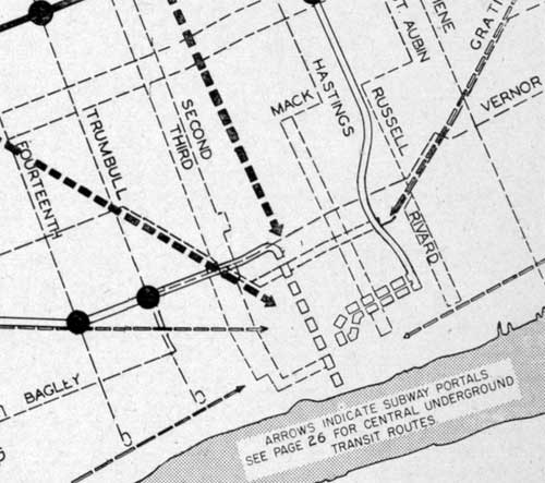
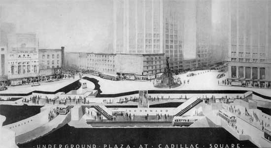
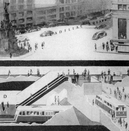
Central Underground Terminal
There will be substantially more traffic in the central area during postwar years.
Detroit could not afford a program of street widening in the downtown area to meet postwar traffic requirements. This has been tried in Detroit and elsewhere. Conflict between mass transportation vehicles and passengers, pedestrians and individual automobiles would continue.
Segregation of mass transportation vehicles from pedestrian and vehicular movements on the surface of streets could be accomplished by the construction of a central underground terminal for cars and trolley buses from all radial routes.
In addition to the Grand River and Woodward dips, two trolley bus roadways are planned beneath existing streets in the central business district: one connecting the Fort and Jefferson routes, and the other, the Michigan and Gratiot routes. The portal at the west end of the Fort-Jefferson underground terminal would be located in Fort between Fifth and Sixth and the portal at the east end, in Jefferson between Beaubien and St. Antoine.
Through routing of the Fort and Jefferson lines is recommended although separate turn-back loops could be made on surface streets just beyond the portals. The total length of this subway would be approximately 1.2 miles. Underground Stations on this route would be located just west of Third, between Cass and Wayne, at Woodward, near Randolph and at Brush.
Similar facilities would connect the Michigan and Gratiot trolley bus lines. The route would follow Monroe between Woodward and Randolph. Portals are planned in Michigan between First and Second and in Gratiot between St. Antoine and Hastings.
The total length of this subway would be approximately 1.1 miles. Underground Stations would be located at Shelby, at Woodward, at Library and at Brush.
In the underground portion of all four routes, stops at curb-level side platform stations would be so spaced that reasonably high operating speeds could be attained. After emerging from their respective portals, the lines would render local service for the balance of their length, making approximately six stops per mile.
Substitution of trolley buses for street cars and the subsequent removal of tracks would provide space for central malls. These would simplify and improve vehicular traffic and replace the present hazardous ~safety” islands as refuges for pedestrians caught midstream by a change in traffic control signals.
The only city motor buses operating to the downtown area would be: the express buses from the Grand River Expressway using Woodward south of Vernor; the buses from Second-Third-Hamilton line which would terminate in a loop on Lamed, Woodward and Congress; and the express buses from the Hastings-Crosstown-Gratiot route which would enter the central business district on Lafayette and leave by way of Monroe.
Network of Local Routes
The proposed network of local bus routes are shown on the maps in this report. There would be one or more bus lines within convenient walking distance of every home in the developed sections of the city. Lines have been located to serve every industrial district in the city. Every secondary business district would have one or more local bus lines serving it.
Transfer privileges would be offered at every desirable point where transit routes intersect. Station facilities would be provided at transfer points on the rapid transit routes. Combined use of rapid transit and surface rail lines would save time for patrons and reduce operating costs.
The entire local network would be equipped with gas or diesel buses. Size and type of equipment for each route has been determined by us and used in estimating the total number of vehicles required as well as their cost. These determinations are not shown in detail since more complete study should be given to the characteristics of each line at the time it is to be rerouted and converted from its present type of equipment. It is possible that on many lines over-all increase in business might require larger buses than justified on the basis of 1941 traffic levels.
"The proposed transit system is based on a frame of rail, trolley-bus and bus-trunklines coordinated with a network of local bus routes:"
"Almost all new transit traffic would be below street level in the downtown area. Passengers would benefit from faster and safer service. There would be protection from weather and improved access to buildings:"
"The Woodward rail line and the Fort, Michigan, Gratiot and Jefferson trolley-bus lines would be served by a large station with numerous entrances and convenient connections between routes:"
 |
Detroitnerd
Member
Username: Detroitnerd
Post Number: 435
Registered: 07-2004
Posted From: 209.69.221.253
| | Posted on Monday, April 25, 2005 - 8:40 pm: | |
Gee, I'm sure glad we didn't waste any money on stuff like that! |
Detroit_stylin
Member
Username: Detroit_stylin
Post Number: 761
Registered: 10-2003
Posted From: 66.202.227.12
| | Posted on Monday, April 25, 2005 - 8:44 pm: | |
Damn Detroit's very own Grand Central Station....
But wasnt the MCS already built at the time that they were planning this? Seems as if it's fate had been determined from way back then... |
Eric_c
Member
Username: Eric_c
Post Number: 232
Registered: 11-2003
Posted From: 68.76.202.10
| | Posted on Monday, April 25, 2005 - 8:50 pm: | |
With such an elaborate plan and all the wealth in post-war Detroit, how could this system NOT have been built?
Can we please just get a Woodward streetcar line? Please? |
Detroitnerd
Member
Username: Detroitnerd
Post Number: 436
Registered: 07-2004
Posted From: 209.69.221.253
| | Posted on Monday, April 25, 2005 - 9:22 pm: | |
DS: This is more comparable to New York City's cluster of connected subway stations underneath Grand Central Terminal or Times Square. MCS is your Grand Central Terminal-style train station, with intercity trains arriving and departing on any of dozens of tracks. |
Gannon
Member
Username: Gannon
Post Number: 2955
Registered: 12-2003
Posted From: 69.14.202.196
| | Posted on Tuesday, April 26, 2005 - 1:34 am: | |
I noticed that Riverfront Drive...kinda like Lakeshore Drive in Chicago. Imagine a freeway to the Pointes from downtown past Belle Isle, freaky.
Careful there MikeM, heard the rumor that the first five people to have their hands on this plan died mysteriously. Never know, it might be cursed by ol' Henry, they sure were. You got ANY information on what happened to this plan...who considered it and when it was voted on?! |
Mikem
Member
Username: Mikem
Post Number: 1449
Registered: 10-2003
Posted From: 68.43.12.165
| | Posted on Tuesday, April 26, 2005 - 1:47 am: | |
LOL, hey, you wanna buy it Gannon?
I haven't any idea of what happened to it once it was submitted to the Transportation Board. The Board consisted of:
Lloyd Reid, City Traffic Engineer
William Dowling, Corporation Counsel
Samuel Gilbert, President of the Board of Street Railway Commissioners
Ernest Knight, President of the City Planning Commission
Paul Krause, Corporation Counsel
Glenn Richards, Commissioner of the Dept of Public Works
Leroy Smith, County Highway Engineer, Board of Wayne Co Road Commissioners
All appointed by Mayor Jeffries, Jr.
For all I know, this could have been thrown out the window and a new one commissioned when the next mayor took office. |
623kraw
Member
Username: 623kraw
Post Number: 622
Registered: 10-2003
Posted From: 68.41.224.200
| | Posted on Tuesday, April 26, 2005 - 5:05 am: | |
Excellent info Mikem - the things that never happened are the most amazing... |
Mikem
Member
Username: Mikem
Post Number: 1457
Registered: 10-2003
Posted From: 68.43.12.165
| | Posted on Tuesday, April 26, 2005 - 11:56 pm: | |
Hornwrecker, here you go:
I thought your brother's recollections sounded familiar. I remember seeing a late '60s National Geographic magazine article about traffic control/highway engineering. Included was a picture taken from one of the cameras, of a traffic jam on the Lodge, red brake lights and all. The caption indicated something to the effect that researchers find that earlier incidents which are no longer there (a dog in the road) create a stationary jam that lasts for hours afterwards. Then I found this today --
quote: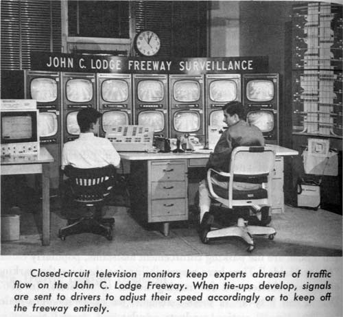
Detroit has been a pioneer city in experimenting with television for traffic control. You probably have noticed the television cameras on the overpasses as you have driven along the John C. Lodge Free way. As you drive into range of these cameras, you are a small part of a traffic control project which involves twelve states.
The use of television in traffic experiments was for several years one of the assignments of the traffic research division. Until the end of 1963 the project was under the joint sponsorship of the Michigan State Highway Department, the Wayne County Road Commission, the U.S. Bureau of Public Roads, and the Department of Streets and Traffic. Since that time it has been financed and administered as a cooperative research project by these agencies and the highway departments of twelve states. However, city personnel assigned to the television study are still members of the traffic research division.
Another of the division’s [Traffic Research Division] responsibilities is to conduct financial studies for the entire department. These include such things as accounting and cost analyses.
All of the divisions and sections mentioned above are located in the main offices of Department of Streets and Traffic in the Water Board Building on Randolph and Farmer.
(Message edited by MikeM on April 26, 2005) |
Hornwrecker
Member
Username: Hornwrecker
Post Number: 19
Registered: 04-2005
Posted From: 67.192.64.34
| | Posted on Wednesday, April 27, 2005 - 12:09 am: | |
Thanks Mikem, it reminds one of how progressive this area used to be, and still is... or maybe that is could be again. |
Jerome81
Member
Username: Jerome81
Post Number: 562
Registered: 11-2003
Posted From: 66.245.57.3
| | Posted on Wednesday, April 27, 2005 - 3:13 am: | |
I can't read this thread. Its too depressing to see what was and what could have been.
And what it is today. Makes me sick. |
Psip
Member
Username: Psip
Post Number: 1
Registered: 04-2005
Posted From: 69.246.13.131
| | Posted on Wednesday, April 27, 2005 - 8:04 pm: | |
Thanks Mikem for your great memory of the Lodge video system. Back in the late 50's that was one heck of a technological marvel. Pushing video down a 1000 ft cable was hard to do; doing it for miles was next to impossible. That system must have cost a fortune.
This is a great thread and a great forum, being that this is my first post here; I hope I can add something of relevance to the discussions. It certainly has challenged my memory.
I remember going downtown on the street car back in the 50's to Hudson's month end sales with my mother. |
Lombaowski
Member
Username: Lombaowski
Post Number: 22
Registered: 11-2004
| | Posted on Friday, September 29, 2006 - 11:41 am: | |
This is an extremely interesting thread and I thank those of you who lent information to it. I guess that means either I'm a Detroit info nerd or just a little strange.
(Message approved by admin) |
Waxx
Member
Username: Waxx
Post Number: 19
Registered: 09-2006
| | Posted on Saturday, October 14, 2006 - 2:01 pm: | |
The things in the illustrations I've seen so far...IMPRESSIVE! I only have 1 question in mind
"Why didn't our 'forefathers' pursue those plans?" Was it polictics? Race? Economical issues? Too far down the road, as it were? And I don't personally find the drawings as well as the threads depressing. In fact, me personally, I find inspiration in them. Because that tells me (being a Detroiter and an artist) that there's still hope 4 Detroit. And another thing, I forgot who said these words, but they hold so true to this day: "People look at things that are and say 'Why?'. But I look at things that never were and say 'Why not?'.
You'll definitely see more of me on this thread because this is a subject that's interesting 2 me.
(Message approved by admin) |
|