Fareastsider Member Username: Fareastsider Post Number: 222 Registered: 08-2006 |
Information on the 10K acre tract is difficult to find. ANyone have some information or maps. I know the 10000 acre tract has its own sections as well I would like to see a pre development map. I also love the name the 10,000 Acre Tract | ||
Gistok Member Username: Gistok Post Number: 3782 Registered: 08-2004 |
Pardon your ambiguity, but what are you talking about?? | ||
Charlottepaul Member Username: Charlottepaul Post Number: 668 Registered: 10-2006 |
I was wondering as well. Does sound interesting whatever it might be. | ||
Fareastsider Member Username: Fareastsider Post Number: 223 Registered: 08-2006 |
It is the large square in the city center here in this image from Mikem in the Ribbon Farm Appreciation Thread. 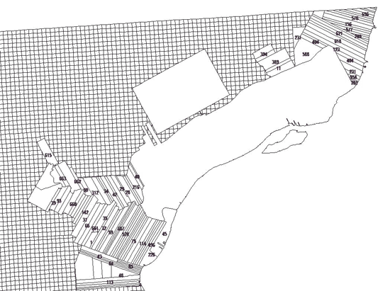 | ||
Jimaz Member Username: Jimaz Post Number: 1670 Registered: 12-2005 |
Is it related to this? http://www.michigan.gov/docume nts/LaborBldg_ExhibitA_Lega_11 3239_7.pdf | ||
Fareastsider Member Username: Fareastsider Post Number: 226 Registered: 08-2006 |
Those are just land descriptions in the 10k tract. the 10k tract is a granted piece of land that has surveying lines like the public land system it is just older so it isnt tied into the public survey system or the french claims. I just dont know the details of its origins or have i ever seen detailed maps of it pre development or with its section lines. The link is just the description of some land parcels within the 10k tract. It has its own sections like a general law township but it is seprate from all general law townships. | ||
Hornwrecker Member Username: Hornwrecker Post Number: 1782 Registered: 04-2005 |
We had a thread about it (last year?), but damned if I can find it with the search. It must have had a different title, than about the 10k tract. | ||
Mikem Member Username: Mikem Post Number: 3180 Registered: 10-2003 |
The Ten-Thousand Acre Tract was a ten-thousand acre tract of land beyond the city limits at the time (1806), which was granted to the city by Congress (before statehood) after the fire of 1805. Judge Woodward and Governor Hull had to travel to Washington to get approval for Woodward's new plan for Detroit. Along with it, they were granted the 10,000 acres for the purpose of granting new land to those who would lose land in the Judge's new scheme, and to sell remaining acres to raise money for the erection of new public buildings, such as a new capitol building and jail. 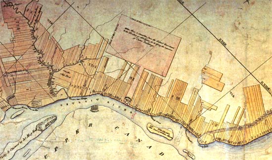 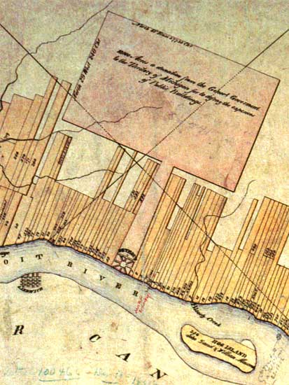 Caption within tract reads, "10,000 Acres. A donation from the General Government to the Territory of Michigan for to defray the expenses of Public Buildings."  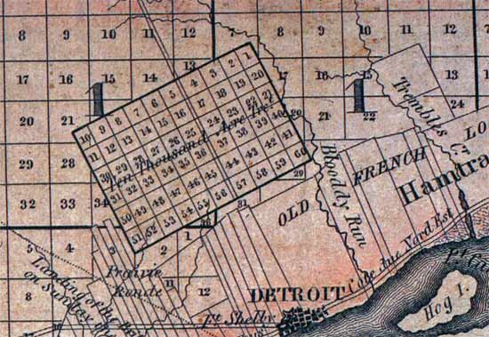 The area was surveyed and plotted after the war of 1812 and divided into 160 acre farms, which Judge Woodward protested vigorously as it disrupted the extension of his repeating geometric plan for the city. | ||
Fareastsider Member Username: Fareastsider Post Number: 227 Registered: 08-2006 |
That is funny that they did not fill in those small narrow strips between the private claims and the 10,000 Acre tract | ||
Mikem Member Username: Mikem Post Number: 3186 Registered: 10-2003 |
The stretch along both sides of Woodward, from Adams north to the 10,000 Acre Tract, was surveyed and divided into lots in 1808. These were called the Park Lots and varied in size. The 10,000 Acre Tract was not surveyed until 1816 and the reason for it's placement apart from the city is due to the existence of the Park Lots. The first map I posted shows the Park Lots section as a narrow strip, connected to, and the same color as the 10,000 Acre Tract. I'm not sure if these Park Lots were part of the same grant as the 10,000 acres. |