Fareastsider Member Username: Fareastsider Post Number: 625 Registered: 08-2006 |
Recently out a Wolcott mill Metropark I followed a now abandoned section of 31 Mile. There were even collapsed and in tact bridges. 4 of them though this link only counts 3. http://www.historicbridges.org /truss/30mile/index.htm Anyways that is just one of many roads not used anymore in the periphery out this way. There are sections of Mayer and Shortcut in Ira as well not used, not to mention the old DUR railbed still in Saint Johns Marsh. Many highways by the state were re-routed and old ones left behind. There is an old on ramp at Hall Road now unused. The thread with the Harper Golf course shows many changes in the roads and the diminished prominence of Greater Mack over time. My uncle had property the was next to an vacated road with a bridge over the Bell River. It was just a steel skeleton and one night someone took the WHOLE THING! What about roads never built but were planned. Anyone know any interesting information or of some old hidden unused roadway in and around Detroit? I suppose an old roadway could be a ruin. | ||
Gistok Member Username: Gistok Post Number: 5520 Registered: 08-2004 |
One never built roadway that comes to mind is the "Imperial Highway", a diagonal roadway that was supposed to go from western Wayne County diagonally into Oakland County and from there northeastward into Macomb County towards Armada I believe. This was mentioned on another thread. As you mentioned with Greater Mack, there are many roadways that have some strange twists, dead ends, and new beginnings. Several streets originating in Detroit come to mind. One is Hayes Ave. Which begins at Harper & Chalmers. It continues on until it ends at 8 Mile & Gratiot. Then a few blocks north of 8 Mile it begins again, but this time as a residential street. It continues on towards 10 Mile, where it starts to become a more important street, but still residential. Between 10 & 11 Mile Hayes has a very strange look to it. The houses are set way back from the street, as though Hayes was at some point going to be widened, but never was. Then Hayes crosses over I-696/11 Mile and ends 1 block north at Groesbeck. Then Hayes starts back up at 11 1/2 Mile and becomes a main thoroughfare (boulevard) as the side entrance for Macomb College South Campus. Then north of 12 Mile it ends as a boulevard, and becomes a residential street again. Then north of 15 Mile it ends again. It starts up again north of 16 Mile (Metro Parkway) branching off of Utica Road, and progressively increasing in importance as a business lined thoroughfare until it reaches Hall Rd. Then it continues on northward into Macomb County as a semi-rural road. 2 other roads that do this on the far east side are Beaconsfield and Kelly Rd. The same Beaconsfield that starts at Jefferson in Grosse Pointe Park stops and starts several times until it becomes the western perimeter to Macomb Mall, and continues northward. Ditto for Kelley road farther west of Beaconsfield. Like Greater Mack, Hayes, Beaconsfield and Kelly Roads likely were little more than contiguous paved or dirt roads in the distant past, but were hacked up into separate segments by parks, freeways and other road projects. | ||
Rbdetsport Member Username: Rbdetsport Post Number: 389 Registered: 11-2005 |
Where is this old unused onramp at hall road? | ||
Abracadabra Member Username: Abracadabra Post Number: 120 Registered: 04-2007 |
Farmington Road at Shiawassee. Farmington used to go down the hill and had a bridge going over the river. The roadway and bridge are still there. Super-long link : http://maps.google.com/maps?f= q&hl=en&time=&date=&ttype=&q=F armington+Rd+%26+Shiawassee+Rd ,+Farmington,+Oakland,+Michiga n+48336,+United+States&sll=42. 334386,-83.273829&sspn=0.13603 3,0.373535&ie=UTF8&cd=1&geocod e=0,42.466100,-83.371460&ll=42 .467246,-83.374557&spn=0.00212 1,0.005836&t=h&z=18&om=1 The hill going down to the river was pretty steep. I heard that a school bus crashed there in the winter, and that lead to it being closed off. | ||
Detroitrise Member Username: Detroitrise Post Number: 249 Registered: 09-2007 |
I agree with Gistok. I find SE Detriot's SW-NE facing streets interesting (Canfield, East Fort St., St. Paul, Agnes, etc.). | ||
Rokk_krinn Member Username: Rokk_krinn Post Number: 59 Registered: 10-2003 |
There is an out of service bridge on Card Road, south of 25 Mile Road, that I used to ride my bike over. Vehicle traffic is not allowed. It's actually kind of interesting that this section of Card Road, between 24 & 25, has been left abandoned. Not sure what the current status is... that area is where "downtown" Macomb Twp is going, so they may be repairing the roads. | ||
Abracadabra Member Username: Abracadabra Post Number: 121 Registered: 04-2007 |
Here is Imperial Hwy. You can see the path it used to take. http://maps.google.com/maps?f= q&hl=en&time=&date=&ttype=&q=F armington+Rd+%26+Shiawassee+Rd ,+Farmington,+Oakland,+Michiga n+48336,+United+States&sll=42. 334386,-83.273829&sspn=0.13603 3,0.373535&ie=UTF8&cd=1&geocod e=0,42.466100,-83.371460&t=h&o m=1&ll=42.319526,-83.386123&sp n=0.008504,0.023346&z=16 This may be a little piece of it - Sorry, didnt meant to blow margins.. If you follow the map above to the northeast, you can see what looks like a section in the woods of Hines Park. (Message edited by Abracadabra on October 14, 2007) (Message edited by Abracadabra on October 14, 2007) | ||
Rbdetsport Member Username: Rbdetsport Post Number: 390 Registered: 11-2005 |
Broughton Road- Starts at 27 Mile and travels south and ends suddenly where the Macomb Township Hall, Macomb Rec Center, Macomb-Suburban Ice Arena, and where the new "Downtown" Macomb is supposed to be. The road turns just south of 25 Mile, but it is apparent that the road used to continue south to 24 mile as a dirt rode because there are old power lines in a straight line and there are always cars parked back there on the old road. Garfield Road- Starts as Garfield Street at Common Road and ends at Groesbeck. Starts back up at Utica Road and Masonic and travels all the way to 22 Mile(Used to end north of 21 mile and start back up about 200 yards north because of an old drain) and stop because of the old Berz-Macomb Airport which is now gone and adding to the sprawling suburbs with Pulte and other company homes. Then the road starts back up between 23 and 24 mile and ends at 24 Mile. Finally, it starts back up between 24 and 25 and ends in the old macomb village where it starts romeo plank back up at 25 a little off the path of the southern part of romeo plank. | ||
Mikeg Member Username: Mikeg Post Number: 1210 Registered: 12-2005 |
Conner St. used to continue north of Base Line Rd. into Macomb County, where it terminated at Sherwood St., as shown on this 1916 map of Warren Twp.: 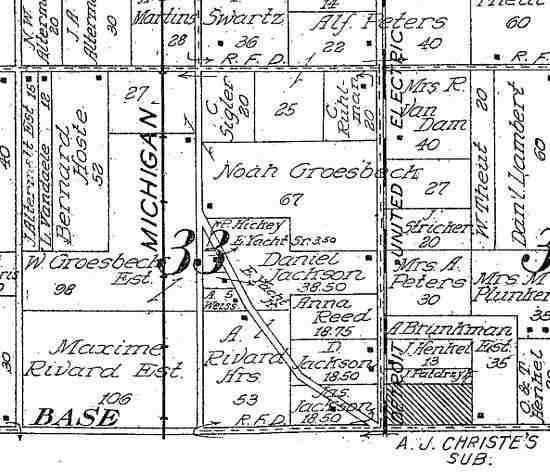 By 1930, this area had been subdivided and in the process, much of Conner St. in Warren Twp. had been vacated: 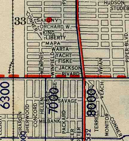 Today, the remaining portion is called Conners Ave.: 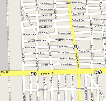 Another "cousin" of the Imperial Highway was the Industrial Superhighway, which was shown as "proposed" on the same 1930 map of Warren Twp.:  Only two short segments (named Industrial Hwy.) were actually constructed near the 10 Mile Rd. and Schoenherr intersection: 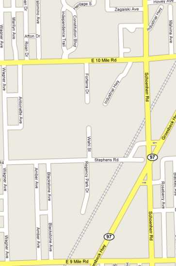 | ||
Blueidone Member Username: Blueidone Post Number: 143 Registered: 03-2007 |
I remember my mom telling me years ago that there was a plan to have a freeway along Mound Road corridor from, I think the Davison or that vicinity, north and then connecting with what is now the M-53 freeway. It was one of the reasons she moved out to Washington Township back in the 60's when she worked at the GM Warren Tech Center. Anyone else ever hear of that plan? Seems like the improvements they have made over the years might be heading in that direction. | ||
Detroitrise Member Username: Detroitrise Post Number: 251 Registered: 09-2007 |
I'm surprised no one has mentioned State Fair. How it ends at Outer Drive/Conner and Begins again at the end of E. Outer Drive's run. | ||
Detroitrise Member Username: Detroitrise Post Number: 252 Registered: 09-2007 |
and the streets along the perimeter of City Airport. | ||
Innovator Member Username: Innovator Post Number: 75 Registered: 07-2006 |
That's why the Mound/696 interchange is so large, to accommodate the planned Mound expressway. | ||
Mikeg Member Username: Mikeg Post Number: 1213 Registered: 12-2005 |
quote: Yes, there was a master plan that called for a future freeway along Mound Rd. from the Davison to 18 1/2 Mile Rd., where it would swing to the east and connect with the M-53 freeway. What that meant was that MDOT would acquire right-of way for the future Mound Rd. project whenever they built state and Interstate routes that would interchange with it. Evidence of that planning can be seen in the I-696/Mound Rd. interchange which was built as if Mound were a freeway. Similarly, when the M-53 freeway was built in the 1960's, MDOT also acquired the land between it and Van Dyke to allow for the future extension of the M-53 freeway towards 18 1/2 Mile Rd. That land sat fallow for more than 40 years until 2004 when the state built the roundabout at Van Dyke and 18 1/2 Mile Rd. which also has on and off ramps connecting to the M-53 freeway. I believe that the official plans for a Mound Rd. freeway were abandoned during the late 1980's. | ||
Jimaz Member Username: Jimaz Post Number: 3507 Registered: 12-2005 |
I recall a bridge that existed in the 1960s that crossed the Clinton River at Kleino Street ("Court" now) in Sterling Heights. 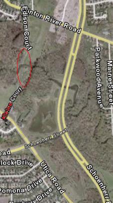 Anyone know the story about when and why that bridge disappeared? The Schoenherr bridge replaced it, obviously. | ||
Gistok Member Username: Gistok Post Number: 5522 Registered: 08-2004 |
That Mound corridor freeway was supposed to connect to the Davison Freeway near McNichols (6 Mile). The Davison Freeway was supposed to continue past its' eastern terminus (near Conant), which was supposed to follow Davison Rd. until McNichols, then continue east and then bend south just after City Airport along the Conner corridor. The I-94 exit at Conner is so peculiar because it was originally intended to be the eastern terminus of the Davison Freeway. And the stretch of Conner from I-94 to Gratiot has a wide band of parkland along the western side of the road because that land was going to be part of the Davison Freeway. | ||
Stinger4me Member Username: Stinger4me Post Number: 95 Registered: 08-2007 |
Does anyone know the year they built Mound Rd.? I lived in the area in the 50's and 60's and it was a divided highway then. Sometimes we use the median as a place to play ball. | ||
Mikeg Member Username: Mikeg Post Number: 1214 Registered: 12-2005 |
The Kleino Road bridge was a very old and short span. During periods of heavy river flow, its roadway approaches acted like a dam, causing water to back-up upstream of the bridge. One of the many state requirements that needed to be met for approving the Schoenherr Road bridges over the Clinton River included the complete removal of the Kleino Road bridge and approaches after the new bridges were open to traffic. It made no sense to require the new Schoenherr bridges to meet a higher peak river flow if the substandard Kleino bridge was permitted to remain in place only a few hundred feet upstream. | ||
Jimaz Member Username: Jimaz Post Number: 3508 Registered: 12-2005 |
Mikeg, thanks. I've been wondering about that for years. When was it demolished? | ||
Jimaz Member Username: Jimaz Post Number: 3509 Registered: 12-2005 |
And what's the etymology of "Mound" Road? Was it a name, an actual mound, an Indian burial mound? | ||
Hornwrecker Member Username: Hornwrecker Post Number: 1910 Registered: 04-2005 |
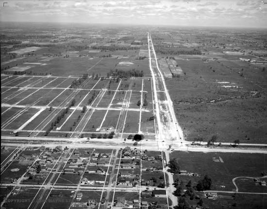 wsu/vmc An aerial photo from the 1930s (?) looking north up Mound Rd from 8 Mile Rd. | ||
Mikeg Member Username: Mikeg Post Number: 1215 Registered: 12-2005 |
quote: Originally, what is now Mound Rd. in Macomb County existed only north of 11 Mile Rd. Northbound travelers from Detroit would use Conner and Sherwood Streets and then jog to the west on 11 Mile Rd. and then north on Mound Rd. It was not until sometime between 1895 and 1916 that Mound Rd. was built between 8 and 10 Mile Roads. Here is a 1916 map showing the last missing section of Mound Rd. between 10 and 11 Mile Roads (apparently it was delayed due to the need to build a bridge over Bear Creek). 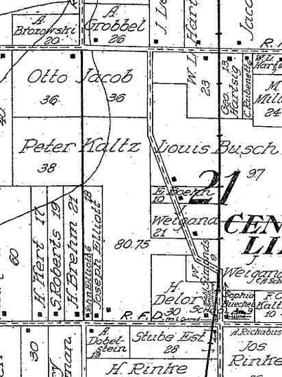 Sometime shortly after 1916, the last missing section was built and sometime before 1932 the first divided highway sections were built in the area between 13 and 14 Mile Roads through Warren Village. The original Mound Road roadbed lies beneath today's northbound lanes. Warren Village's entire business section along the west side of Mound Rd. had to be demolished to create the room for the southbound section of the divided highway. | ||
Dodgemain Member Username: Dodgemain Post Number: 177 Registered: 04-2005 |
Does anyone remember the electronic variable speed limit signs on Mound in the "60's? They would change the speed on the overhead signs according to traffic flow. My Dad said at the time it was a experiment. | ||
Mikeg Member Username: Mikeg Post Number: 1216 Registered: 12-2005 |
Those overhead "speed limit" signs were the result of an experiment conducted by the General Motors Research Labs and the Macomb County Road Commission to regulate traffic flow and prevent back-ups. I remember them as having three separate speeds with a separate illuminating lamp behind each. The actual speed limit on Mound was 45 MPH and the signs showed the recommended speed to travel if you wanted to avoid hitting the brakes at the next traffic light. So if you were stopped and then given the green light, the first overhead sign would have the 45 lit up and subsequent signs would show you the 45 and when you arrived at the next light, it would turn green just as you got there and you would not have to brake (unless there was a lot of traffic already stopped for it). I believe the other two speeds were 35 and 25 and they were shown to those who came through the green light too late to be assured of making the next green light. It was not a very sophisticated system, it just used electromechanical timers and it was an attempt to see if drivers would modify their natural behavior if they could see that they would be rewarded by not having to stop as much. | ||
Hybridy Member Username: Hybridy Post Number: 172 Registered: 08-2006 |
yea the 90' medians on mound on the lower east side definitely would've accommodated the freeway the mt elliot bridge over the rails is part of that too seems like a great opportunity for community gardens or a linear park it'd be much better than a gathering places for trash and misc car. parts | ||
Fareastsider Member Username: Fareastsider Post Number: 626 Registered: 08-2006 |
The old onramp for Hall Rd. is west of the freeway today. Just west of the onramp. You can see it here. http://i141.photobucket.com/al bums/r50/fareastsider/Hallramp -2.jpg The green line on there is the route of an old Road called Snover Rd. which ran from Hall Rd. ....acutally The W. P. Rosso Hwy to Gratiot along the Chesterfield/Macomb Twp border. IT was vacated and now there is a road called MArketplace Blvd within a shopping development of the same name. Snover Rd though is no more. I believe you used to be able to get to the freeway from Gratiot but I wasnt driving when it was still around. The Card Rd bridge is supposed to be replaced with a covered bridge but has been put on hold due to budget concerns. | ||
Yaktown Member Username: Yaktown Post Number: 242 Registered: 02-2006 |
Great thread, old maps/roads always interest me. I have had the following thought for a while now, perhaps some DYes-er can enlighten me. How come 14 Mile Road is "missing" between Southfield and Evergreen Roads? Is it because of the Birmingham Country Club? I always thought that since 14 Mile Road is a border between townships that it should have gone unbroken. | ||
Scottr Member Username: Scottr Post Number: 800 Registered: 07-2006 |
Fareastsider, I think that snover road was at one time m-29. from http://www.michiganhighways.or g/listings/MichHwys20-29.html# M-029 quote: I think this was the 'new bypass' to crocker road. the 94 listing says in 1963: quote: | ||
Tayshaun22 Member Username: Tayshaun22 Post Number: 373 Registered: 02-2005 |
South Huron Rd. exit on 275 looks like a highway that was never built. http://maps.google.com/maps?f= q&hl=en&geocode=&time=&date=&t type=&q=new+boston,+mi&ie=UTF8 &ll=42.138141,-83.376446&spn=0 .006969,0.014591&t=k&z=16&om=1 It's only use is an entrance to Willow Metropark. | ||
Fareastsider Member Username: Fareastsider Post Number: 627 Registered: 08-2006 |
A road in Chesterfield called Callens I grew up on has been twisted and altered many times over the years. Callens runs from 23 Mile Rd south to Sugarbush at the intersection of Sugarbush and Sugarbush! at the southern end of this 1.5 Mile road Sugarbush makes a 90 degree turn. I believe because of an old re routing years ago probably by the turn of the century. Here is the road today. http://maps.google.com/maps?q= 23+Mile+Rd+%26+Callens+Rd,+New +Baltimore,+MI+48047,+USA&sa=X &oi=map&ct=image and http://i141.photobucket.com/al bums/r50/fareastsider/CAllens. jpg Its original route in 1859. http://i141.photobucket.com/al bums/r50/fareastsider/Callens1 859.jpg Anyways I learned of some of its rerouting from my dad and witnessed its recently alignment to Baker Road as the two roads were nearby and created a traffic problem. In fact from 21 Mile road if you took Sugarbush north you may not realize it but that direct roadway has 3 names now due to all of this re-routing. Where Sugar bush turns at 90 degrees you then are driving on CAllens and when you cross 23 Mile Rd you are on Baker Road. All their own roads but lined up over time. Anyways the small 1.5 mile section that is Callens had a new bridge built over the Salt River in 1982 and made the angles of the road smoother. Callens used to cross the Salt River and formed a T intersection with Hooker Road seen here. http://i141.photobucket.com/al bums/r50/fareastsider/Callensa ndriver.jpg Same image highliting changes http://i141.photobucket.com/al bums/r50/fareastsider/Callensa ndriver2.jpg just up the road from there some sharper road angles were changed for traffic and even a part of the Salt River was moved. http://i141.photobucket.com/al bums/r50/fareastsider/CAllensi mprovements.jpg Two years ago the section by 23 was routed behind some newer stores and lined up with Baker Road to make a 4 way intersection. Recent pictures on maps.live shows the new intersection today. http://maps.live.com/?q=34000+ 23+mile+road+chesterfield+mich igan&go=Search&mkt=en-us&scope =&FORM=LIVSOP Here is the original road route pre 1982 http://i141.photobucket.com/al bums/r50/fareastsider/EastCall ens.jpg You can see along the river a sidewalk exists which leads to a school at the end of Hooker Rd. along the still existing Right of Way. The road has a long history as it connects with Sugarbush they run more or less along an old indian trail which was here before the Europeans. There is a lot of history and changes in that little road! |