Novine Member Username: Novine Post Number: 178 Registered: 07-2007 |
For the map geeks, this is one of my favorite local anomalies. On this map: http://maps.google.com/?ie=UTF 8&t=h&om=1&ll=42.391017,-83.43 0862&spn=0.005531,0.01133&z=17 the area west of Eckles Road and east of I-275 is in Plymouth Township. But the only way to reach that area is through the City of Livonia. The difference in jurisdiction probably explains the lack of development on the Plymouth Township side compared to the Livonia side. Anyone have similar examples where freeways, railroads or waterways have created a jurisdictional island where the only way to access a portion of a city or a township is through an adjoining community? | ||
Gsgeorge Member Username: Gsgeorge Post Number: 259 Registered: 08-2006 |
"lack of development" there might have more to do with the large size of the properties, and proximity to freeway than with the border anomaly. There are many such municipal boundary anomalies in the state and elsewhere. I always thought it was weird that this part of Grosse Pointe Shores extends into Macomb County. Imagine living out on this peninsula in Lake Erie--you'd have to go through OHIO to get to your home in MICHIGAN. | ||
Mikeg Member Username: Mikeg Post Number: 1220 Registered: 12-2005 |
Slightly OT, but still on the topic of boundaries: guess where the boundary between Michigan and Ohio lies in this aerial photo. 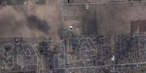 Sort of gives lie to The Michigan Advantage™. | ||
Billpdx Member Username: Billpdx Post Number: 46 Registered: 05-2006 |
I don't know... the Michigan side looks a lot more appealing than that Ohio suburbia. | ||
Upinottawa Member Username: Upinottawa Post Number: 997 Registered: 09-2005 |
With respect to having to drive through Ohio to get from Michigan to Michigan, that is nothing compared to what the folks in Point Roberts, WA have to do to get to other parts of their own state, i.e. drive through Canada. Hope they have their i.d. and the line ups at the border are not too long.... http://maps.google.ca/maps?q=P oint+Roberts,+WA,+United+State s+of+America&sa=X&oi=map&ct=ti tle | ||
Charlottepaul Member Username: Charlottepaul Post Number: 1840 Registered: 10-2006 |
"The difference in jurisdiction probably explains the lack of development on the Plymouth Township side compared to the Livonia side." Or just the fact that it is RIGHT NEXT TO THE FREEWAY!! | ||
Novine Member Username: Novine Post Number: 179 Registered: 07-2007 |
"Or just the fact that it is RIGHT NEXT TO THE FREEWAY!••• If that was the case, how do you explain all of the other residential development along I-275? This area has the advantage of having a sound wall to buffer the freeway noise. Compare that to this new subdivision in Farmington Hills: http://www.mapquest.com/maps/m ap.adp?address=%5b21334%2d2136 9%5d%20Woodhill%20Dr&city=Nort hville&state=MI&zipcode=48167& country=US&title=%3cb%20class% 3d%22fn%20org%22%3e%5b21334%2d 21369%5d%20Woodhill%20Dr%3c%2f b%3e%3cbr%20%2f%3e%20%3cspan%2 0style%3d%22display%3ainline%3 bmargin%2dbottom%3a0px%3b%22%2 0class%3d%22locality%22%3eNort hville%3c%2fspan%3e%2c%20%3csp an%20style%3d%22display%3ainli ne%3bmargin%2dbottom%3a0px%3b% 22%20class%3d%22region%22%3eMI %3c%2fspan%3e%20%3cspan%20styl e%3d%22display%3ainline%3bmarg in%2dbottom%3a0px%3b%22%20clas s%3d%22postal%2dcode%22%3e4816 7%3c%2fspan%3e%2c%20%20%3cspan %20style%3d%22display%3ainline %3bmargin%2dbottom%3a0px%3b%22 %20class%3d%22country%2dname%2 2%3eUS%3c%2fspan%3e%3c%2fspan% 3e&cid=lfmaplink2&name=&dtype= h | ||
Novine Member Username: Novine Post Number: 180 Registered: 07-2007 |
"Slightly OT, but still on the topic of boundaries: guess where the boundary between Michigan and Ohio lies in this aerial photo." That's the sprawl coming out of Toledo into Sylvania. If you go further east, you'll be hard pressed to see where the boundary lies as Bedford Township functions as a bedroom community of Toledo. | ||
Fareastsider Member Username: Fareastsider Post Number: 638 Registered: 08-2006 |
Dont forget about Michigans "lost penninsula" that is accessible only through Ohio! | ||
Upinottawa Member Username: Upinottawa Post Number: 998 Registered: 09-2005 |
With respect to that development in Farmington Hills, also I could think about is the following: He's got an interstate runnin' through his front yard You know, he think, that he's got it so good | ||
Detroitnerd Member Username: Detroitnerd Post Number: 1513 Registered: 07-2004 |
There's one part of Dearborn that's accessible only through Detroit, on the opposite side of the Rouge Plant, Riverside Drive and Fordson Island. Look on the map, it's an odd little place! | ||
Hudkina Member Username: Hudkina Post Number: 67 Registered: 12-2004 |
Brownstown TWP is one of the few townships in Michigan that is split into several relatively large "chunks". The largest part (16,165 people in 15.30 sq. mi.) is just south of the city of Taylor and east of Huron TWP. The second largest part (1,932 people in 5.23 sq. mi.) is on Lake Erie at the very southern tip of Wayne County and the smallest part (4,892 people in 1.91 sq. mi.) is bordered by Woodhaven to the north, Gibraltar to the east, Rockwood to the south, and Flat Rock to the west, all of which were incorporated from land that was once a part of Brownstown TWP. (Message edited by hudkina on October 19, 2007) | ||
Novine Member Username: Novine Post Number: 181 Registered: 07-2007 |
Lansing Township and Kalamazoo Township also have been broken into fairly large pieces that are not contiguous. In Ann Arbor, you can find township islands from Ann Arbor, Scio and Pittsfield townships deep within the city's border. | ||
Track75 Member Username: Track75 Post Number: 2656 Registered: 10-2003 |
I had a neighbor whose house was partly in Brookline, MA and partly in Newton, MA. The boundary ran through his living room and kitchen. I always thought that was weird. | ||
Detroithabitater Member Username: Detroithabitater Post Number: 53 Registered: 10-2006 |
Similar to the Ohio-Michigan peninsula, but this one is between Canada and the USA at Point Roberts! http://maps.google.com/?ie=UTF 8&om=1&ll=48.973006,-123.03588 9&spn=0.216797,0.688019&z=11 | ||
Detroitnerd Member Username: Detroitnerd Post Number: 1514 Registered: 07-2004 |
IIRC, Henry Ford's childhood house was on the property line between I think Greenfield and Springwells Twps. I heard it was a joke in their household that you could dine in one township and sleep in another. | ||
Gistok Member Username: Gistok Post Number: 5538 Registered: 08-2004 |
In St. Clair Shores there is a subdivision just south of the Milk River where the only access is from Grosse Pointe Woods. The streets are called North and South Colonial Court. These steets are only accessed from Morningside Drive in GPW, which ends at South Colonial Court. The next street south of them, known as Robert John, is already in GPW/GPS. Another anomaly of these 2 streets is that they have a (313) 88x area code and prefix (like far east side Detroit and northern Grosse Pointes). The rest of St. Clair Shores has a (586) area code with most prefixes as 77x (although there are others on the north end of SCS). | ||
Fareastsider Member Username: Fareastsider Post Number: 642 Registered: 08-2006 |
I have surveyed properties along West Parkway and other western streets such as Dale where the city limits went through the garage and even house. The due E/w border line through the french areas of SCS and GP are funny as borders usually follow those old french lines. I wonder how taxes work at those houses and which city do you live in? | ||
Gistok Member Username: Gistok Post Number: 5540 Registered: 08-2004 |
Yes, I've wondered that as well Fareastsider. The border runs east/west, and yet the streets run west-north-west to east-south-east. I thing the homeowners pay certain predetermined percentages to both localities. And as for where you vote... I guess it depends on where the majority of the house is located. | ||
Gsgeorge Member Username: Gsgeorge Post Number: 262 Registered: 08-2006 |
I know that with border anomalies in the Netherlands and Belgium, in a region called Baarle-Nassau/Hertog, addresses are determined by where the front door is. This causes problems because there are actually a few houses where the border between Belgium and The Netherlands goes through the front door. "As each house is deemed to pay taxes in the country where its front door is located, it is an old tradition in Baarle to move the front door some meters if that is profitable for the taxes, especially for shops. This is part of making the best out of a strange situation. In 1995 a remeasurement of all the borders of enclaves according to modern exact standards was completed. This gave rise to some problems of this kind. In at least one case a house would have had to move from Belgium to the Netherlands. The inhabitants did not want that to happen, but the solution was simple: they moved the front door of their house. One formerly Dutch meadow (with one cow grazing there) "moved" in 1995 from the Netherlands to Belgium, as it was recognised that it had to be a Belgian parcel." In the case of the houses in GP and SCS, I'd say it has to do with the street address, wherever that happens to be physically located on the street. It can only be in one city. (Message edited by gsgeorge on October 19, 2007) | ||
Hpgrmln Member Username: Hpgrmln Post Number: 227 Registered: 06-2007 |
"There's one part of Dearborn that's accessible only through Detroit, on the opposite side of the Rouge Plant, Riverside Drive and Fordson Island. Look on the map, it's an odd little place!" Ive seen it on a map and youre right.I was always wondering....what exactly is on that island. Looks industrial, almost like a baby Zug Island | ||
Detroitnerd Member Username: Detroitnerd Post Number: 1518 Registered: 07-2004 |
Hpgrmln: Dad was a Dearborn cop for a while, and had to drive his scout car through Detroit to check on Fordson Island. I've no idea what's there; didn't even check the aerial view... | ||
Detroitnerd Member Username: Detroitnerd Post Number: 1519 Registered: 07-2004 |
Hpgrmln: Dad was a Dearborn cop for a while, and had to drive his scout car through Detroit to check on Fordson Island. I've no idea what's there; didn't even check the aerial view... | ||
Upinottawa Member Username: Upinottawa Post Number: 1000 Registered: 09-2005 |
Check out Sugar Island, Michigan (on the Detroit River near Boblo Island). What is that strip of land that runs east-west between Boblo and Sugar Island and crosses the international boundary? The coordinates are: 42.090389,-83.138609 (plug them into Google Maps and use the Hybrid function). | ||
Gnome Member Username: Gnome Post Number: 230 Registered: 08-2007 |
From Dearborn city website: Dearborn has two islands of note: Fordson Island and Suwanee Island, both man-made. FORDSON ISLAND: Fordson Island is a small islet in the middle of the Rouge River in the southeastern part of Dearborn. The 8.4-acre island was created in 1922 when federal engineers, at the request of Ford Motor Co., straightened and deepened a section of the Rouge River south of the Rouge Plant. The river originally was too shallow and wound too much to properly accommodate the Eagle Chaser boats from World War I that the Ford Motor Co. wanted the Rouge Plant to utilize. Federal engineers found it more efficient to cut directly across the land rather than deepen the existing river. Fordson Island was born upon completion of the $10 million channel. Access to the island was possible by boat and by a plank bridge from southwest Detroit. Today, the only land access remains the small one-lane bridge. After the channel was completed in 1922, several people bought the lots on the island to put up riverfront homes. In 1970, six residents still called the island home. Through the city’s Operation Eyesore, the remaining five dwellings were removed in 1989. With this went the last residents. The island today is home to a Marathon Oil facility and a second private company. | ||
Gsgeorge Member Username: Gsgeorge Post Number: 263 Registered: 08-2006 |
Always wondered about Fordson Island. It looks interesting because it preserves the original banks of the Rouge. | ||
Detroitnerd Member Username: Detroitnerd Post Number: 1524 Registered: 07-2004 |
The Gnome knows... Thanks, Gnome! | ||
Yaktown Member Username: Yaktown Post Number: 243 Registered: 02-2006 |
Yay, another map thread! One of my favorite local oddities is Novi Township. All that's left of the original township is a little section in the south-central area of the City of Novi. I'd estimate it to be 0.2 sq miles. I also find it odd that the city of Northville crosses 8 Mile Road into Oakland County. Are there any other municipalities that cross county borders? | ||
Hudkina Member Username: Hudkina Post Number: 68 Registered: 12-2004 |
There are some houses that straddle both Hamtramck and Detroit in the Casmere St/Talbot St area. | ||
Gsgeorge Member Username: Gsgeorge Post Number: 264 Registered: 08-2006 |
Sylvan Lake The border between Sylvan Lake and West Bloomfield runs along the train tracks south of Orchard Lake Road, but there is a portion of the border that juts out into the development south of the tracks. One quarter-mile long, 250-foot wide segment of Sylvan Lake shoots across the diagonal streets seen here. The border crosses some houses. Birmingham Springdale Golf Course, seen here, is part of Birmingham, but you have to go through Bloomfield Township to get there. It is connected to Birmingham by a very narrow section of border that runs along each side of the train tracks that go over Big Beaver. Ann Arbor There are some really crazy boundary quirks in Ann Arbor. The city and the township are coterminous but they have separate borders. The city is progressively "absorbing" the township in a patchwork manner, adding properties as they are sold to the city, etc. In some areas, a single property will be part of Ann Arbor Township while the surrounding area will be City of Ann Arbor. This creates a number of enclaves and exclaves. There are too many to list here, but for those of you using Google Earth, turn the City Boundaries layer on and take a look. This high-density development of apartment buildings on Liberty is one such example; they are part of Ann Arbor Township, while the surrounding area is City of. Milan Milan, in south Washtenaw county, straddles the border with Monroe County. About half of the city lies in Monroe County, but it only contains about 1/4th of its residents. The border runs along County Street. Because County Street meets Main St. at an angle, the county border actually runs through some businesses. |