Mortalman Member Username: Mortalman Post Number: 409 Registered: 03-2007 |
So the King Theater and FREDRO both have the same exact address? The reason I'm asking is because reference is made to the Fredro Theatre Building on the Detroit Polonia 100 Years ~~ Early Historical Sites website and I quote, "Fredro Theatre Building, Chene between Fredericks and Kirby, designed in 1913 by architects Norm Feldman and Alfred Scaler, one of Detroit's earliest Polish drama stages." But, they give no address. Here's the link: http://wayne.migenweb.net/polo nia.html (Message edited by mortalman on October 08, 2008) | ||
Townonenorth Member Username: Townonenorth Post Number: 252 Registered: 10-2007 |
Yes, it is the same address as the later King theatre. 5317 Chene. | ||
Townonenorth Member Username: Townonenorth Post Number: 253 Registered: 10-2007 |
Here's a nice photo of the Hamtramck Zosia's from about 1981. This photo is found in the HAL digital Collection, Library Of Michigan. http://haldigitalcollections.cdmhost.com/cdm4/browse.php?CISOROOT=%2Fp129401coll10  | ||
Townonenorth Member Username: Townonenorth Post Number: 254 Registered: 10-2007 |
These photos are copyrighted, so I'm posting the links to them for your enjoyment. Early Photo of St. Alburtus church http://quod.lib.umich.edu/cgi/ i/image/image-idx?id=S-DPA1IC- X-EB02E419%5DEB02E419.TIF St. Albert's Church St. Albert's Church, Slavic and Polish Catholic church, on St. Aubin Ave. and Fremont. White brick church with plain glass windows and tall steeple topped with cross. http://quod.lib.umich.edu/cgi/ i/image/image-idx?id=S-DPA1IC- X-DPA2124%5DDPA2124.TIF Star Theater Hamtramck 1950 Posters and stills from a Polish film on marquee at the Star Theater in Hamtramck, Michigan Also a line outside the theater with a view down the street. http://quod.lib.umich.edu/cgi/ i/image/image-idx?id=S-DPA1IC- X-EB02M445%5DEB02M445.TIF http://quod.lib.umich.edu/cgi/ i/image/image-idx?id=S-DPA1IC- X-EB02M576%5DEB02M576.TIF | ||
Mortalman Member Username: Mortalman Post Number: 410 Registered: 03-2007 |
That's a great "old" shot of Zosia's with the sign painted on the side of the building. Also, thanks for verifying the address of the King Theatre as being the same as FREDRO's. Here's another one that's got me puzzled. On that same site, Detroit Polonia 100 Years ~~ Early Historical Sites website they mention, "Fredro (Harmonia ) Hall, SF corner of Leland and Russell, this building built in 1887 was Detroit's first Polish hall, the site of innumerable meetings and social gatherings." Whatever ever was there back in 1887 is long gone. But, what I was wondering about was this name, "FREDRO" which was the name of the former King Theatre and now the FREDRO (Harmonia) Hall." I was just wondering if either you or Hornwrecker or anyone else has any insights to those names, "FREDRO" or "Harmonia" and where they came from? I don't have access to Sanborn Maps now but I was wondering if either of you could look at that site at the corner of Leland and Russell to see what was there in 1887. The quote said, "SF corner of Leland and Russell" but I'm sure they meant "SE" corner but the map will tell for sure. I have looked for photos of FREDRO (Harmonia) Hall but with no luck. I'm sure there will be photos in the dead newspaper files so when I get down to the Burton Collection I'll see what I come up with. (Message edited by mortalman on October 08, 2008) (Message edited by mortalman on October 08, 2008) | ||
Townonenorth Member Username: Townonenorth Post Number: 255 Registered: 10-2007 |
Here's a couple files that are relevant to the Polish community. THE IMPORTANCE OF BEING POLISH:THE COMPLEX INTERACTION OF COMMUNITY IDENTITY AND RACE IN HAMTRAMCK’S POSTWAR DEVELOPMENT http://deepblue.lib.umich.edu/bitstream/2027.42/58629/4/zajac-importance_polish.pdf DETROIT'S ETHNIC NEIGHBORHOODS AT THE END OF THE NINETEENTH CENTURY http://deepblue.lib.umich.edu/bitstream/2027.42/50936/1/161.pdf By the way, the Fredro theatre was owned by Stanley Janiszewski. (Message edited by townonenorth on October 08, 2008) | ||
Townonenorth Member Username: Townonenorth Post Number: 256 Registered: 10-2007 |
Here's a couple of articles, one a death notice, about Harmonia Hall. I can't say whether the fire one is related to this Harmonia. October 21, 1893 Page 12 George Boehnlein, who was burned to death in the Harmonia Hall fire, Detroit, last Saturday night, was well known to the Soo drug trade. He was in the city only a week or so ago. Boehnlein was popular here and news of his death was received with deep regret. Detroit, MI, 1903. Accident occurred on May 4 at Canfield Avenue on the GTW's line to Brush Street Station. Earlier in the day, a LS&MS train brought a group of people from Toledo to a Polish festival held at St Josaphat's Church and Harmonia Hall. When the train returned at 8:00 p.m. that evening, it stopped on the main line to pick up passengers. This was not a regular station stop and the train apparently did not send out an employee to flag the track. At 8:30 p.m., a GTW train from Chicago was heading for Brush Street station. It was most likely No. 8. The crew knew nothing abut the train at Canfield Avenue until they were right on top of it and had no chance to stop the train in time. Hearings showed that the crew on the excursion train were all "off the extra board" and not acquainted with the area and took too much for granted. [MRC-4/1976] Also, here's Harmonia Hall. 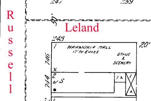 Later in its life, it was listed as a dance hall, and a Church of God in Christ Church. No mention of it being Fredro Hall. May have been a typo? (Message edited by townonenorth on October 08, 2008) | ||
Mortalman Member Username: Mortalman Post Number: 418 Registered: 03-2007 |
Does anyone know where Reverend Joseph Karasiewicz the last pastor of Immaculate Conception is buried? Any info such as an obit, prayer card or anything related to his passing would be nice to see. Also, I have looked all over the internet for a good map of Detroit's old Poletown prior to the GM Poletown Plant being constructed. Does anyone have a good map of Detroit's Poletown with the boundaries delineated that they can post or direct me to? Didn't know where to ask these questions. This seemed as good a place as any to ask. | ||
Eastsidedame Member Username: Eastsidedame Post Number: 565 Registered: 12-2006 |
Thanks for the identification of 5317 Chene. That brickwork has always driven me wild, i.e. love it. I can't remember when it wasn't painted that garish white, though. Oooh! Mortalman: Here y'go! http://www.findagrave.com/cgi- bin/fg.cgi?page=gr&GSln=Karasi ewicz&GSbyrel=in&GSdyrel=in&GS st=24&GScntry=4&GSob=c&GRid=53 65982& | ||
Mashugruskie Member Username: Mashugruskie Post Number: 85 Registered: 09-2006 |
Fr. Francis Mueller was pudgy and died at age 45. Fr. Jan Mueller was thin, tall and wore glasses. I do have the name of the architectural firm for St. Albertus in one of my books if you would like me to look them up. (Message edited by mashugruskie on October 18, 2008) | ||
Mortalman Member Username: Mortalman Post Number: 421 Registered: 03-2007 |
Thanks, Eastsidedame! Now, if someone could come up with a map of Poletown I'd be a happy man!! | ||
Eastsidedame Member Username: Eastsidedame Post Number: 568 Registered: 12-2006 |
Start smiling, Mortalman! http://picasaweb.google.com/Ho rnwrecker/1930sDetroitMap# A big debt of thanks goes to Hornwrecker...the map is greatly detailed, though I'm not sure what all of the symbols mean. But it's teeming with information and history. Thanks, H! What a rush finding this link! Research is my drug! | ||
Townonenorth Member Username: Townonenorth Post Number: 266 Registered: 10-2007 |
Photo 7 of 8 in the Picasaweb site has the key to the maps. The red dots are public schools, crosses are parochial schools. Coach and Car lines are in a solid red line. | ||
Eastsidedame Member Username: Eastsidedame Post Number: 569 Registered: 12-2006 |
Great to know! Map #8 has a detailed map of Downtown with many business names attached to locations. BTW: Coach & car..meaning bus and streetcar, right? I found my Dad's childhood street on Map #3. A very small street, I can understand why a lot of people hadn't heard of it. It was easier to download the map in question, then view it super-sized. | ||
Mortalman Member Username: Mortalman Post Number: 423 Registered: 03-2007 |
Those are great maps Hornwrecker and Eastsidedame and I hope I don't sound ungrateful but how do I delineate the boundaries of Poletown which was my original question? But, believe me I’m smiling while I look at these maps. I’d just like to make that smile wider with the knowledge of the Poletown boundaries. | ||
Hornwrecker Member Username: Hornwrecker Post Number: 2131 Registered: 04-2005 |
Well, you look at the data for the census tracts in Detroit for foreign born, and/or Polish speaking households, or at a map such as the one I posted in the Early Polish Detroit HOF thread and compare it to the locations of businesses in the Polk guides and other references. Then draw it in over a street map in a program like Photoshop or GIMP (free program). Do it in layers so it'll make it easier to go back and amend or change the outlines and to make use of it for future projects. You could also make different layers that show the changes over time by boundaries and densities. That would make an interesting animation. Sounds like an interesting and worthwhile research project that should keep you off of the streets for quite a bit of time. Have fun. | ||
Townonenorth Member Username: Townonenorth Post Number: 267 Registered: 10-2007 |
Now that would be an interesting, dynamic presentation! I think it's an interesting project. Looking forward to seeing the results. | ||
Mortalman Member Username: Mortalman Post Number: 426 Registered: 03-2007 |
Hornwrecker, now those are the kinds of maps that have meaning as far as I'm concerned. 99% of the maps give a snapshot in time which is fine for a moment in time. But, to see the evolution of anything i.e. Poletown would be to make the numbers and boundaries come to life. These are rare maps, indeed! I generally know where Poletown is/was but to delineate specifically is another story all together. My interest lies in the correlation between where Poletown was and is now to the invasion of the Poletown Plant that tore the heart out of the neighborhood. The soul is still there but the heart, now, that's another story all together. | ||
Hornwrecker Member Username: Hornwrecker Post Number: 2132 Registered: 04-2005 |
It would be easy to make an animated gif of it; just need someone to provide all the (frames) maps done to the same scale and color theme, and it would only take a few minutes to make. I missed all the Poletown shenanigans when I was in the Navy, so it was a kind of a "poof, it's there" thing to me. I know there were some other threads on the topic, and I think Mikem (or somebody) did some aerials with the plant imposed over the old neighborhood. | ||
Mortalman Member Username: Mortalman Post Number: 427 Registered: 03-2007 |
Hornwrecker, When you say, "just need someone to provide all the (frames) maps done to the same scale and color theme" do you mean Sanborn Maps? I do have access to them and if you tell me what to do I can put them together and send them to you prepared for you to make. If you want to talk about it off thread let me know because I have nothing but time to do it if I know what to do. You missed the Poletown thing when you were in the Navy and I missed the Riots of 1967 in the Corps sitting in a rice paddy in SE Asia. Lovely! | ||
Eastsidedame Member Username: Eastsidedame Post Number: 571 Registered: 12-2006 |
This is how I did plotted the current location of the plant on the 1930 map: For this exercise only, use Harper for I-94, Richmond Street for I-75. Take a pencil. Start at the corner of Harper and Mt. Elliott. Draw a line up along Mt. Elliott, it will change into Conant. You'll then hit Christopher Street, where there's a fine looking building, Huron Machinery. Might have been a school at one time. Continue the line along the railroad tracks tracks until you get to Denton. Continue along Denton, which becomes E. Euclid until you get to the corner of Euclid and Richmond Street (approx. modern location of I-75). Draw your line down along Richmond to E. Grand Blvd. For the Southern border, continue along E. Grand Blvd. as it turns. When you've hit the corner of EGB and Harper, stop. Then continue your line along Harper until you're back at the corner of Harper and Mt. Elliott. My map is too big to post, but it's not hard to figure do. Everything inside the line you drew is basically where the plant is now. (Message edited by eastsidedame on October 18, 2008) | ||
Mortalman Member Username: Mortalman Post Number: 428 Registered: 03-2007 |
Hey good one, Eastsidedame! That’s exactly what I've been looking for so all I need to do is get out my detailed street map and trace those street boundaries you mentioned. Then if I want to post it I guess I could scan it in pieces or maybe put it on Flicr like Hornwrecker did. My only question is where did you get the information about what streets determine the boundaries? In other words what is the authentication or verification of what you said in your post? | ||
Eastsidedame Member Username: Eastsidedame Post Number: 572 Registered: 12-2006 |
I pulled up Google Maps and Hornwrecker's #3 map and looked at them side by side. These might not be spot-on, but they're pretty close. Please let me know if there are any adjustments to be made. | ||
Hornwrecker Member Username: Hornwrecker Post Number: 2133 Registered: 04-2005 |
I found a map I did of the rerouting of the streets around the Poletown plant, Hamtramack Blvd, I94 service drive and EGB are the green lines.  1964 Pure Oil map  Bentley Historical Library, UoM | ||
Eastsidedame Member Username: Eastsidedame Post Number: 574 Registered: 12-2006 |
What about the area bordered by the RR tracks, Conant and Euschner? That's my Dad's old neighborhood, he lived on Manhattan. | ||
Mortalman Member Username: Mortalman Post Number: 431 Registered: 03-2007 |
Can anybody tell me how it was that all the Catholic Churches, Baptist Churches, other churches, businesses, government offices, factories, all the residents and their homes were cleared out of Poletown, and, Beth Olem Jewish Cemetery is still standing even if it is surrounded by the GM Poletown Plant? How did that little cemetery become the only thing that made it past the wrecking ball? | ||
Townonenorth Member Username: Townonenorth Post Number: 273 Registered: 10-2007 |
Because it's A) A cemetery B) Not a building, and C) Open twice a year. At least from what I've been told. 30 seconds with a search engine produces this gem. http://hamtramckstar.com/index .php/beth_olem_cemetery | ||
Mortalman Member Username: Mortalman Post Number: 432 Registered: 03-2007 |
I'm looking for a serious answer to a serious question other than "because" so let me ask again, quote: | ||
Townonenorth Member Username: Townonenorth Post Number: 274 Registered: 10-2007 |
I gave you 3 concrete reasons why. And a link. But since you insist, here's the Poletown Decision from March 13th 1981. http://www.nd.edu/~dbetson/courses/documents/PoletownVDetroit.pdf While the decision was flawed, and overturned later, the deciding factor in all of this was control of the property, in my reading of the decision. The ability of limiting the access to the property was defined by this passage: "Public control of the use of the land after transfer to the private entity invests the taking with far greater public attributes than would exist without control and fortifies the justification for the abridgment of individual property rights. Once the land in this case is sold to General Motors, there will be no public control whatsoever over the management, or operation, or conduct of the plant to be built there." Since GM limits access to the Cemetery, and exerts all security control over it, they more than likely allowed it to stand versus a protracted battle. The neighborhood, churches, and stores being more public uses than an semi-abandoned cemetery, fell under this "public control". (Message edited by townonenorth on October 19, 2008) (Message edited by townonenorth on October 19, 2008) | ||
Eastsidedame Member Username: Eastsidedame Post Number: 583 Registered: 12-2006 |
Mortalman, regarding your ? from Sept. re: Houston Architecture Info Forum (HAIF). As I live in the Houston area, I've read the HAIF boards and they are beautifully done and tremendously fascinating. All this from a city that bulldozed its past until 1995, when most of the good stuff (esp. the great pop-luxe stuff) was already gone. All this NASA-era "City of the Future" crap started to catch up with Houston. The few remaining 19th Century commercial buildings in the downtown area are treated as precious relics. No worries, tho. Just build stuff that just LOOKS old (but has solar panels,wi-fi and A/C)..like the impediments on these condos built in 1998:  It's worth a look to see how a public city architecture side s/b organized. As Mortalman indicated, the Architect's section is very informative. http://www.houstonarchitecture.info/haif/index.php I don't know of a site that catalogs and stores building plans for Detroit structures online. I don't know how the City of Detroit handles historic building plans. Whatever Detroit may have purged, for cost reasons, there's got to be a copy in Lansing. Houston (a fairly well-off city) has drawings for buildings built only after 1988 online, for example. I doubt if Detroit is anywhere near that. It is much less expensive to store records for many years than to microfilm them, anyway. However, I would be happy to pay taxes for mass digital scannings of blueprints, deeds, etc. That's something that's actually useful to me, and everybody. Not the crap in that stupid bailout. Excuse me, I digress... I'm guessing, since nobody else is, that even plans and specs for a building that's gone, Old Slumpy for example, or my grandma's old house on Iroquois, should be on file with either the city, state, or architectural records with the AIA (if orig. arch. firm is extinct) or perhaps library or university. |