Rust Member Username: Rust Post Number: 74 Registered: 08-2004 Posted From: 64.118.136.130 |
Check out Google Earth. This has to be the best free mapping tool yet. http://earth.google.com/ It includes 3D Building representations for major cities including Detroit. This a image I snapped with the software. It requires a download but is well worth the minimal effort. 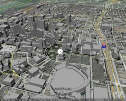 | ||
Blessyouboys Member Username: Blessyouboys Post Number: 232 Registered: 07-2005 Posted From: 69.209.187.24 |
this is like so 6 months ago | ||
Ndavies Member Username: Ndavies Post Number: 1562 Registered: 10-2003 Posted From: 129.9.163.105 |
Obviously rust does sleep. https://www.atdetroit.net/forum/mes sages/50492/49867.html (Message edited by ndavies on January 17, 2006) | ||
Jt1 Member Username: Jt1 Post Number: 6455 Registered: 10-2003 Posted From: 198.208.159.20 |
I never realized the city was so grey. Must have been overcast that day. | ||
Bvos Member Username: Bvos Post Number: 1159 Registered: 10-2003 Posted From: 66.238.170.32 |
Yeah, the technology has been around for a few months, but it's an outstanding program none the less. A lot of things that were formerly the exclusive domain of GIS can easily be done with this program. A great program for novices and professionals alike. | ||
Rust Member Username: Rust Post Number: 75 Registered: 08-2004 Posted From: 64.118.136.130 |
My apologies!!! | ||
Sumotect Member Username: Sumotect Post Number: 153 Registered: 08-2004 Posted From: 64.243.32.9 |
Another very cool mapping site. Maps.A9.com checkout Detroit streetscape. Photos all taken in summer, so you can remember what it felt like. | ||
Iseries840 Member Username: Iseries840 Post Number: 136 Registered: 08-2005 Posted From: 12.31.43.97 |
Few months? This program was formerly a subscription service called Keyhole and has been around for a few years. | ||
Jimaz Member Username: Jimaz Post Number: 62 Registered: 12-2005 Posted From: 68.2.191.57 |
I appreciate being reminded of these mapping tools. I'm trying to refamiliarize myself with Detroit before moving there and they're a great help! Be sure to turn on the Google Earth Community layer for user-supplied placemarks and note the mileage measuring tool in the tools menu. I have some 20 buildings placemarked so far. In A9, in the window reflections, you can sometimes catch a glimpse of the truck used to take the photos. A9 still has a lot of territory left to photograph. Maybe they're hiring. | ||
Dougw Member Username: Dougw Post Number: 944 Registered: 11-2003 Posted From: 136.1.1.101 |
No need to apologize in this case, Rust. From reading the previous thread, it wasn't obvious to me that this service included 3D representations of downtown Detroit, which your picture nicely demonstrates. | ||
Psip Member Username: Psip Post Number: 871 Registered: 04-2005 Posted From: 69.246.13.131 |
The a9.com has old pictures, I hope they keep them. Its useful to see what was there. 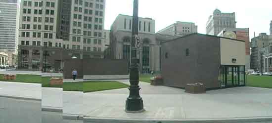 pardon the poor pasteing, I will get better  | ||
Taj920 Member Username: Taj920 Post Number: 82 Registered: 01-2004 Posted From: 68.42.252.205 |
won't work on a Mac unless you have 10.4 | ||
Huggybear Member Username: Huggybear Post Number: 124 Registered: 08-2005 Posted From: 68.79.96.11 |
Hey, that's why they invented Guardian Yellow! | ||
Tomoh Member Username: Tomoh Post Number: 57 Registered: 11-2004 Posted From: 68.40.189.92 |
This may have been old news but thanks for the reminder. I had installed Google Earth but had no idea it could do 3D representation of Detroit, something I'd been wanting to see! Too bad my hometown of Columbus didn't get picked for this feature (although Cleveland and Cinci were). | ||
Psip Member Username: Psip Post Number: 901 Registered: 04-2005 Posted From: 69.246.13.131 |
It wouldnt be long before there will be very few gray blocks on that map. I wonder if there is a delete building button??? |