7even Member Username: 7even Post Number: 4 Registered: 03-2006 Posted From: 64.108.150.210 |
If you have not used Google Earth you should check it out. You can view Detroit from above. Also look at the buildings in 3D form. It has been out for a while so I am sure some have seen it. | ||
Jams Member Username: Jams Post Number: 3284 Registered: 10-2003 Posted From: 68.249.44.157 |
It was brought to our attention awhile ago. I've used it quite a bit recently to check out houses and neighborhoods that I possibly might buy into. (Lofts are of no interest to me, I like being in a house.) | ||
Wolverine Member Username: Wolverine Post Number: 154 Registered: 04-2004 Posted From: 24.231.201.120 |
I prefer using local.live since they offer higher resolution images of Detroit, plus birdseye imagery Here's a sample of the resolution you can get http://flickr.com/photo_zoom.g ne?id=146646259&size=o | ||
Livernoisyard Member Username: Livernoisyard Post Number: 684 Registered: 10-2004 Posted From: 69.242.223.42 |
I use Google Earth with my Garmin ForeRunner 301 combo HR monitor/GPS watch. It seems to make very faithful maps of my exercise runs. The 301 even measures the elevation of the path. | ||
Corktownmark Member Username: Corktownmark Post Number: 186 Registered: 12-2004 Posted From: 69.246.27.152 |
Google earth is a good way to get oriented to downtown, for example.. The pics are getting kinda old though. There is much new development in corktown and downtown since the pics were taken. | ||
Mackinaw Member Username: Mackinaw Post Number: 1509 Registered: 02-2005 Posted From: 69.221.35.202 |
Google earth is really easy to use, but thanks to Wolverine I've found that that local.live.com aerials are a bit newer, and those "birds eye view" compilations, when available, are awesome. | ||
Spacemonkey Member Username: Spacemonkey Post Number: 22 Registered: 03-2006 Posted From: 63.102.87.27 |
How come the maps on Google earth are a few years out of date? My new construction house in Rochester Hills shows as an empty lot, yet it was built 2 years ago. What gives? | ||
Wolverine Member Username: Wolverine Post Number: 155 Registered: 04-2004 Posted From: 24.231.201.120 |
My best guess is it has to do with where google earth gets their maps from. I think they purchase the maps from some other company that compiles the satellite images of a particular location every few years. So despite google earth being relatively new, some of the maps are out of date. I look forward to when a new batch comes along. I have a feeling they will be more crisp and possibly more detailed. | ||
Mackinaw Member Username: Mackinaw Post Number: 1513 Registered: 02-2005 Posted From: 69.221.35.202 |
That's the thing about new construction... Whelp, it doesn't have One Kennedy Square either. I assume they update every few years. The only way I can determine that the photo in my area is a few years old is by looking at which trees had been cut down (dutch elm disease of the late 90s) along my street. I don't like the sporadic nature of the high res images. Ann Arbor is in low-res on google, but all of Indiana is high-res. | ||
Chitaku Member Username: Chitaku Post Number: 323 Registered: 03-2006 Posted From: 68.43.107.72 |
I'm guessing the pic is from mid 2003. My parents house in Clarkston wasn't built and they have lived there since August 03, also my car is in the driveway at my old house with my parents, where I haven't lived for 3 years. | ||
Chitaku Member Username: Chitaku Post Number: 324 Registered: 03-2006 Posted From: 68.43.107.72 |
how do you get local.live to show pics, all i could get was a drawn map | ||
Dnvn522 Member Username: Dnvn522 Post Number: 120 Registered: 11-2004 Posted From: 204.24.64.25 |
Not the downtown aerials. Check out the shot of Compuware in the two programs. | ||
Harsensis Member Username: Harsensis Post Number: 52 Registered: 07-2005 Posted From: 71.227.102.82 |
I haven't checked on Google Earth, but in Google maps it caught a plane flying over the Southfield near Grand River. I thought that was pretty cool. | ||
Mackinaw Member Username: Mackinaw Post Number: 1530 Registered: 02-2005 Posted From: 69.221.35.202 |
Ah good point Dnvn. I don't know what I was thinking. The "birds-eye" shots though are awesome and seem to be from 2005. I hope they expand this. A lot of cities are almost fully covered. | ||
Mikem Member Username: Mikem Post Number: 2518 Registered: 10-2003 Posted From: 68.43.15.105 |
Harsensis...Southfield, just south of McNichols: 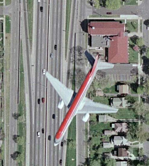 And on the front lawn of the Ford World HQ:  | ||
7even Member Username: 7even Post Number: 7 Registered: 03-2006 Posted From: 64.108.150.253 |
Cool pictures, it almost looks like the bottom one is grounded. | ||
Harsensis Member Username: Harsensis Post Number: 53 Registered: 07-2005 Posted From: 71.227.102.82 |
Yup, That's it. I thought that was pretty cool. | ||
The_aram Member Username: The_aram Post Number: 4883 Registered: 10-2003 Posted From: 68.41.124.8 |
The overhead pics of Detroit have to be from before mid-2003, as St. Cyril's is still there. My only frustration with Google Earth is that their aerial pics of Ann Arbor are ridiculously low-res. Other than that, it's the greatest way to waste a lot of time. Flying around the globe looking at shit... | ||
Arc312 Member Username: Arc312 Post Number: 25 Registered: 01-2006 Posted From: 217.125.119.173 |
I´m studying abroad in Madrid, and I use google earth to see where I live and and where things like La Plaza Mayor and El Prado are. The Images for Madrid are prett cool. But because I´ve only been here for 2 weeks, I couldn´t tell you how old the images are. | ||
7even Member Username: 7even Post Number: 9 Registered: 03-2006 Posted From: 198.109.26.19 |
Heres a site that does not have new photos, but does have awesome old aerial photos. It has photos back to 1949 of the whole metro area. http://www.culma.wayne.edu/aer ial_photos/ | ||
A_franklins_son Member Username: A_franklins_son Post Number: 44 Registered: 11-2003 Posted From: 68.42.242.129 |
The_aram, I agree. I live in A2 and it frustrates me to see the low resolution pictures of the area. Ypsilanti has higher resolution pictures, no fair! Who or what determines resolution of satellite images for any given area? I've always wondered... | ||
Clark1mt Member Username: Clark1mt Post Number: 66 Registered: 06-2005 Posted From: 68.61.191.145 |
Some areas have aerial photos (like the Detroit area). Some of the high-res sets are actually satellite photos. The determination of coverage for aerial photos in GE is dependent on which aerial photo producers have sold rights or have been outright bought by Google. The determination of coverage for high-res satellite coverage is somewhat random from what I can tell. As far as the date of the imagery for the Detroit area outside of downtown, it from April or May of 2003, according to multiple sources (Terraserver and USGS metadata). I don't know when the newer downtown set is from (other than the fact that it is probably from a summer weekday around noon), only that before it was added, Ford Field was still shown under construction. |