Mikem Member Username: Mikem Post Number: 588 Registered: 10-2003 Posted From: 68.43.12.160 |
Rustic was talking on another thread (GR/Fenkell/Greenfield Pics) about how the creeks in Detroit disappered with all the development over the decades. Here's Conners Creek before it too disappeared... It seemed to start in the area of Nortown. That's Eight Mile Rd at the top, Mound is left of center, McNichols is just off the bottom, and the street labeled "electric" is Van Dyke which had an electricified interurban running up to Centerline. The road on the east side of Mt Olivet, turning northwestward after crossing the tracks, is Conner. Note the settlement called North Detroit (Nortown?) at the intersection of the Michigan Central's Bay City Line and Nevada, with Davidson running in from the southwest: 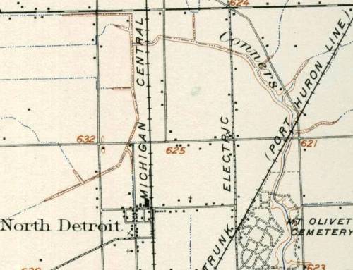 After flowing through Mt Olivet, it ran south between Conner on the east and French Rd on the west, or in other words, right where the main runway of Detroit City airport is. Lynch Rd runs along the south side of Forest lawn into French. French runs southeast into Gratiot at the bottom right corner, where a settlement called Leesville existed. Does anyone know anything about Leesville? 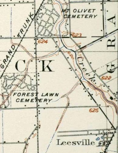 South of Gratiot and east of Conner Rd is an area called Trombley. The creek followed Conner, or vice versa, on the west side, crossing Harper then Shoemaker before entering Grosse Pointe Township from Gratiot Township just north of Mack (the long dashed line running through the letter C in Creek - the Detroit city limits still ended at Waterworks Park): 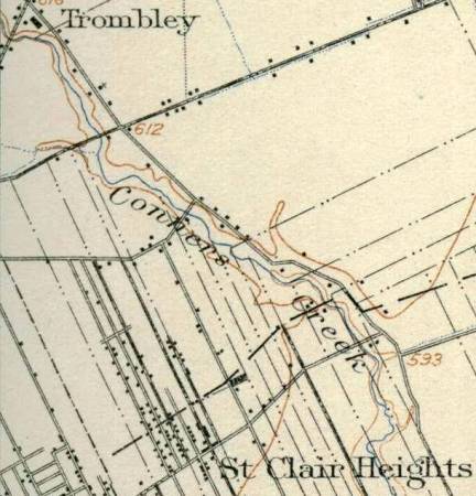 South of Mack, it flowed through an area called St Clair Heights, between Conner and St. Jean, home of the future Chrysler assembly plant. South of Jefferson, it probably dispersed into a marshy area called Fairview on this map, where as development encroached, it was forced into an angling manmade ditch. Edison's Conner Creek power plant was built between 1915 and 1921 and that's probably when the creek was diverted again, straight to the Detroit River: 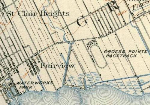 Here's the entire route, but it's a crappy stiching together of two scanned images, severely compressed: 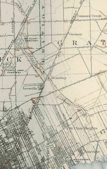 Now, how does the settlement called Conners Creek at Gratiot & 7 Mile relate to the creek itself? 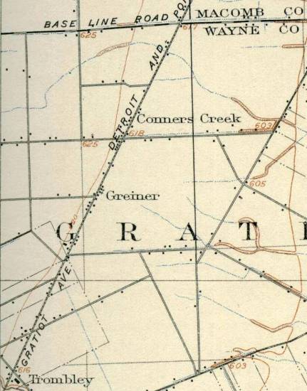 | ||
Bibs Member Username: Bibs Post Number: 86 Registered: 10-2003 Posted From: 64.12.116.196 |
My father works at Conners Creek and I familiar with the grounds since he has a boat at the marina on Edison property. The Detroit Water Department is building a huge facility where Conners Creek empties into the Detroit river. My father mentioned that this is also the creek where a submerged car was found with a body in it. There is another tread on this subject as well. I think the cross streets are Freud and Conner or one street East of Lycaste and intersecting with Freud. | ||
Bvos Member Username: Bvos Post Number: 528 Registered: 10-2003 Posted From: 68.73.199.233 |
Several community groups on the eastside are working to create a greeway bike/walking path along the old path of Conner Creek. The ultimate goal is to possibly unearth Connor Creek. Right now they'll settle for a bike path along and over it. http://www.greenwaycollab.com/ CCGMP.htm I know Libby would probably be interested in taking a look at that map. If they're not able to run the path along the actual creek, at least they'll know where it originally was for history's sake. Also check out the Bloody Run creek which used to run down Chene and end where Harbortown is now. The students in the Architecture program at UDM have done a lot of reasearch and projects on the Bloody Run. Here's the project that started things off: Metro Times Article: http://www.adamah.org/press/MT -2001.html Video (Some really incredible graphics and a very exciting plan): http://www.adamah.org/vision/v ideo.html If this stuff really peaks your interest, the architecture staff at UDM would probably love to look at your map and they'd probably love to talk about the work they've done on the project so far. | ||
Mikem Member Username: Mikem Post Number: 596 Registered: 10-2003 Posted From: 68.43.12.160 |
Thanks Bvos...I'd be happy to share it with anyone who wants to see it. Bloody Run was long gone by the time my map was produced. As I look at how Conners Creek meets the river, I remember how the Seven Sisters (Detroit Edison's Conners Creek station) were aligned on a north-south axis. Maybe it was built parallel to this creek mouth. I went searching for any history of the plant but only found this from Raymond Miller's "Kilowatts at Work":
| ||
Hamtramck_steve Member Username: Hamtramck_steve Post Number: 1249 Registered: 10-2003 Posted From: 68.41.216.208 |
"Bloody Run" is also known as Parent's Creek, and it started near Conant and Holbrook. There was a large-ish pond/swimming hole there, where the Holbrook Creek more or less ended. (Disclaimer: the above info is from a written description. I've never seen a map to confirm it.) | ||
One_shot Member Username: One_shot Post Number: 91 Registered: 11-2003 Posted From: 205.188.116.197 |
Thats pretty cool! Can't believe it ran all the way up to 8 & mound! | ||
Frankg Member Username: Frankg Post Number: 3 Registered: 08-2007 |
There was a question about Leesville, and I have an answer (I think)! When my grandpa Vincent P. Goeddeke (1902-1990) died, he left behind a manilla envelope with a bunch of newspaper articles he collected over the years. One of these articles was a xerox copy of apparently a book chapter that talks about Leesville. I have no idea what book this came from but if anybody knows, please let me know. When my grandpa was about 10 years old, his dad and older brother built a house at 6108-6110 Crane, which is just a few blocks away from Gratiot-Harper, etc. So I suppose my grandpa knew at least one of the people in this book chapter, and that is probably why he saved it. Please forgive transcription errors, but here it is: "Among my earliest memories were the trips to the grocery store. Cash and carry business in those days was, of necessity, confined almost entirely to small items. We would pick out what we wanted, with the help of the clerk, just as we do nowadays, but instead of carrying it out with us the clerk would put it aside for delivery. The first grocery I remember was Kalthoff's, in a building that was afterwards torn down to cut Pennsylvania Avenue through to Gratiot. There was a saloon on the Harper Avenue side of the store and the grocery on the downtown side. Mr. Kalthoff spend [sic] most of his time waiting on trade in the saloon. If I remember correctly, Robert Kalthoff, Jr., generally waited on us. He was just a boy, 16 or 18 years old, but very businesslike. August Kalthoff built the store in 1871 as a hardware store. He had the first hardware store and the first Post Office in Leesville. Robert C., his son, was then four years old. The settlement was just beginning to look like a village. In summer they called it Leesville and in winter they called in Louisville. Sometimes they had to put three or four 18-inch planks in front of the store so people could get to it. I can still remember that mud and it was really something. Riding the "plug" down to Sheridan Avenue we would often see wagons stuck in the mud, abandoned by the owner until he could come back with a shovel and dig it out. They used to tell about a man finding a hat in the middle of Gratiot Avenue. Going over to pick it up he found a man's head under it. "Want some help?" He asked. "No, I'm alright," replied the other, "I'm just driving to town with a load of hay." All the farmers wore rubber boots and had trouble keeping them on their feet. We put stepping stones at Jean Avenue (Marcus) so we could cross Gratiot to get the street car, but in two or three days they had sunk out of sight and we had to get some more. At the age of 23 Robert C. Kilthoff married Miss Matilda Michaels. They moved to Mt. Clemens, but returned a year later to buy the entire Gratiot-Harper corner and open a grocery and saloon in his father's old store. Their children, in order of birth, were: Matilda Gertrude, Antionette Dorothy, Viola Elizabeth, Robert A. and Edgar N. During the drive for state and national prohibition of the liquor traffic people used to say that if all saloons were run like Kalthoff's there would be no need of prohibition. Mr. Kalthoff recalled that there were 22 brickyards and a sawmill along Fort Gratiot Road. Later he built a new front on the store and when the city street numbers came along it was 2396 Gratiot Ave. Back of the store, almost halfway to the Church of our Savior, was Nelson Jackson's blacksmith shop. Although there was no "spreading chestnut tree" over his shop, he exemplified to us children that Longfellow's "The Village Blacksmith." to the grownups also, I believe, for he, his work and his family were loved and respected for miles around. They were members of the Church of Our Savior. Isadore William Connors, nicknamed Dick, a descendant of Henry Connor, tended bar for Mr. Kalthoff from 1904 to 1915. After about a year of bartending he got quite a scare one day when two Walpole Island Indians came in, got drunk, and began breaking furniture. Young Dick, 23 years old, was alone in the store and at first did not know what to do. but he could talk French and tried it on them. They understood the French and he soon quieted them down and they went out. In 1912 the Kalthoff grocery and saloon was torn down to cut Pennsylvania Ave. through to Gratiot, and Mr. Kalthoff built a block of stores and moved his home around on Pennsylvania Ave. Soon after that he opened a hardware store in East Detroit for his children, who now had families of their own." Then on page 228 there is a photo of the Kalthoff building, captioned: "Leacock's Corner, Gratiot & Harper." My Grandpa's writing underneath says: "The name on the building is Kalthoff. This picture is about 1910." | ||
Frankg Member Username: Frankg Post Number: 4 Registered: 08-2007 |
According to the book "The Makings of St. David's" (1959), Trombley was the name of the family who owned the farm. Mrs. David Trombley, a widow, donated a portion of this farm in 1919 to the Catholic Church for a new church in the area. This church was called St. David's, in honor of her late husband, David. The church was closed in the 1980's, but the buildings are still there on Outer Drive just east of Gratiot. | ||
Flanders_field Member Username: Flanders_field Post Number: 21 Registered: 01-2008 |
I attended St. David Grade school 1961-69. There was a plaque inside the school commemorating the donation of the land to build the church, rectory, convent, and school by Mrs. David Trombley, who is an ancestral relation to me. The street next to the church-school was named for Rosemary Trombley, whether it was her name or possibly a daughter, I do not know, and the people who would are now long-dead. The street that I lived on was named for Wilfred Trombley as well. My father claimed that Conner Creek ran through the middle of our block until it was covered over when the houses were built. | ||
Detroitgig Member Username: Detroitgig Post Number: 7 Registered: 04-2008 |
Flanders-Field, I just found this great site yesterday. I grew up on Wilfred and there was a Trombley family across the street and down the block from us, close to Gunston. We played at Flanders Field and my family has nothing but great memories from living in that neighborhood and Detroit in the 50's-70's. Did you live on Wilfred? Where? | ||
Flanders_field Member Username: Flanders_field Post Number: 270 Registered: 01-2008 |
Yes, I lived several houses down on the same side of Wilfred as the Buehler Funeral Home on the other side of Gratiot. I moved into a Westland apartment after my parents sold the house in late 1981, we had lived there since 1957. I also have so many great memories of those years living in NE Detroit. Would not trade a day of growing up there, for a year in the suburbs during that time. | ||
Mikec Member Username: Mikec Post Number: 1 Registered: 11-2008 |
I might know just about all of you. Grew up on Glenfield between Gratiot and Roseberry. Went to St. David until 9th grade when it closed. | ||
Frankg Member Username: Frankg Post Number: 700 Registered: 08-2007 |
Welcome to the forum, Mike! I lived on Wilshire near Roseberry, between Gunston and Roseberry. Lived across the street from one set of grandparents and 4 short blocks and two long blocks from my other grandparents on Kilbourne. Went to St. David's until 1971, then moved to Lansing. I tried to start a "Where are all the St. David's Aviators" thread a while ago but it didn't really take off. No pun intended. | ||
Kensingtony Member Username: Kensingtony Post Number: 31 Registered: 09-2008 |
My ex wife lived on Glenfield about that same time.She was about 4-5 houses east of Gratiot,south side of the street,big old barn looking place.She also went to St.David's till it closed then went to Bishop Gallagher.She was Chris Longhi. | ||
Eastsideal Member Username: Eastsideal Post Number: 61 Registered: 10-2007 |
quote: I realize that the top post on this thread is ancient history, having been posted over 4 years ago now, but does anyone know what year those maps are from? I ask because my relatives lived in the areas marked as Fairview and St. Clair Heights on that map at right about this time I think. My great-grandparents moved onto Eastlawn north of Kercheval (it looks like Eastlawn is shown as ending at Kercheval here) sometime around 1920 when theirs was the first house on the block and the area was still pretty much out in the country and swampy. My father was born in that house back then, and still lives on the eastside today. | ||
Mikeg Member Username: Mikeg Post Number: 2106 Registered: 12-2005 |
I don't know the date of the maps that MikeM posted but here is an aerial photo of what "Fairview" looked like in June of 1925. Waterworks Park is at the very bottom of the photo and Jefferson angles across the upper left corner of the image. Eastlawn runs roughly parallel to the top edge of the image and intersects Jefferson just above the curve. Click on one of the larger image sizes to see the details. [source: "Early Detroit Images from the Burton Historical Collection"] | ||
Flanders_field Member Username: Flanders_field Post Number: 1335 Registered: 01-2008 |
quote: I think that I know who you are Mikec. Do you remember a Craig A., who lived near you on Glenfield, then moved with his family a block further down near Annsbury? If so, the last I heard, over a decade ago, he and his mother were still living there. | ||
Mikem Member Username: Mikem Post Number: 3745 Registered: 10-2003 |
quote: The chart is the September 1915 printing of the December 1905 edition of the Wayne Quadrangle based on a survey done in 1904. |