Patrick Member Username: Patrick Post Number: 3902 Registered: 10-2003 |
I have never been able to come up with a complete count of ribbon farms in Detroit at one time. I'll be getting more info shortly but figured it's an interesting topic....Windsor ribbon farms as well. How far did upstream/downstream did they extend? http://www.cityscapedetroit.or g/articles/Physical_clues.html pear tree-atcha. | ||
Patrick Member Username: Patrick Post Number: 3903 Registered: 10-2003 |
http://www.anthro.wayne.edu/mu seum/archearlydet/archofearlyd et.htm | ||
Livernoisyard Member Username: Livernoisyard Post Number: 2195 Registered: 10-2004 |
They went about as far inland until they interfered with other farms, or their owners cared to claim. Usually three or four miles, but some shorter ones must have had sections sold off, surrendered, or "stolen." Due to bends in the Detroit River these farms would have to intersect at some point, causing property-rights claims, especially for those on the East Side by GP. These ribbon farms were also along the Rouge as "truck" farms which Ford bought around the early 1900s. Also way downriver by Newport and such. These farms were really all over early French settlements. Some of their old (French) deeds are still honored Downriver and elsewhere. (Message edited by LivernoisYard on January 21, 2007) | ||
Patrick Member Username: Patrick Post Number: 3904 Registered: 10-2003 |
Any make it into SCS? | ||
Detroitplanner Member Username: Detroitplanner Post Number: 832 Registered: 04-2006 |
These farms were also common in other areas around here including Monroe. You can see some evidence of ribbon farms up and down the shores of the great lakes; particularly in the areas where the french settled. | ||
Hornwrecker Member Username: Hornwrecker Post Number: 1736 Registered: 04-2005 |
If you go to the NOAA website and do a search in the historical chart section for the year 1796, you'll find a French map done of the Detroit River for Napoleon. On it are all the farms on both sides of the river, with tables listing the owners. NOAA search | ||
Mackinaw Member Username: Mackinaw Post Number: 2341 Registered: 02-2005 |
Patrick, I'm not 100 percent sure here but I don't think that agricultural land was plotted in the form of ribbon farms too far past Provencal in GP Farms. It is fascinating to see how these plots were developed; first, by the very rich lumber barons who built lakefront houses here and there 1870-1900. After the industrial revolution the ranks of the very wealthy in Detroit also built summer and year-round homes along the lakeshore from Alter to Vernier. Larger clusters of mansions began to be found right on the water on Windmill Point, and near to Jefferson/Lakeshore in Grosse Pointe City and Farms. The "backcountry" from about a quarter-mile inland up to around Warren/I-94 remained farmland as the lakefront population density increased. Then, Grosse Pointe (south/west of Moross) as we basically see it today, with its gridded roads paralleling old farm tracts, was built 1915-1935. A neighbor of mine where I grew up was born the same year his house, which he still lives in, was built. This is near Mack in Grosse Pointe, and he told me about how Mack was once a two lane dirt road, and how his house was among the first in this once-backwater spot, surrounded by fragrant orchards that were divided up into the 50-60 foot wide lots with midsize brick houses for the newly wealthy of the 1920s. The rest is history. Three Mile Drive in Grosse Pointe Park follows the three mile stretch from near Harper to the lake where Henry Russell had his ribbon farm. The oldest brick house in Grosse Pointe is found on a slight ridge at the current corner of Jefferson and Three Mile, presumably on an elevated position before the land sunk into a marsh south of what is now Jefferson. While the Windmill Pointe mansions, and a few other blocks of beautiful houses, were developed pre-1925, most of Windmill Pointe remained marshy and sporadically developed until just before World War II. This point was not farmed, because of the low terrain. One place where an old ribbon farm held on well into the 50s, according to another neighbor of mine, was what is currently Lakeland Rd. in GP, from Kercheval to Mack. One will see that the homes there, as opposed to closer to Jefferson, are of 1950s-60s vintage. That was just an earlier example of the farmer-home developer tension that was rampant throughout metro Detroit's fringes in the 90s. Clearly, the home developers normally win out. | ||
Mikeg Member Username: Mikeg Post Number: 480 Registered: 12-2005 |
The ribbon farms continued north along the west side of Lake St. Clair all the way past New Baltimore, except for stretches near the mouth of the Clinton River (where they were aligned perpendicular to the river, not the lakeshore). The location and owners of these ribbon farms are clearly shown on these 1859 plat maps of Erin Twp. Harrison Twp. Chesterfield Twp. Ira Twp. | ||
Patrick Member Username: Patrick Post Number: 3905 Registered: 10-2003 |
I thought I had heard somewhere that the Emory Ford estate was built over the tract of a former ribbon farm. That and the Newberry mansion. | ||
Mikem Member Username: Mikem Post Number: 2955 Registered: 10-2003 |
All of the Grosse Pointes were, except maybe the Grand Marais. | ||
Terryh Member Username: Terryh Post Number: 99 Registered: 11-2006 |
Canfield between Second and Third I believe was a ribbon farm, if I remember correctly owned by a French physician. | ||
Fareastsider Member Username: Fareastsider Post Number: 48 Registered: 08-2006 |
They also are up along the river in Saint Clair COunty. They are refered to as in surveying as "Private CLaims" as they were claims from the french kings to spur growth here for war heroes and the such. The French claims were left as the survey system was laid out as you can see in the maps posted above. The private claims are found along waters from Monroe to Port Huron. Any time you see roads at that angle you can assume that they are private claims. There are some wierd ones out there like one on Dickinson Island in the flats is just thrown down in the middle of the island and it is interesting seeing the section system just laid around it. The same thing was done with Indian reservations there were 2 in chesterfield and one large one in IRA Twp. the town range system did not even go into their reserves. in fact if you find the original plot of Ira the middle of the township wasnt surveyed cause it was a Chippewa Reserve. Then 20 some years later they placed the survey sections in this part of the township. I will post a link when i find it. I have read that the french way of laying out the land was made to work with natural features in stark contrast to the American system which was orderly to set N/S E/W lines. A good source of finding the private claims is to look at a plat map they clearly show them, and another link I know of actually lists all of the private claims and original owners in Wayne I think that will help Patrick. | ||
Fareastsider Member Username: Fareastsider Post Number: 49 Registered: 08-2006 |
Here is a list of Private claims and original owners http://www.geocities.com/michh ist/landclaim.html | ||
Livernoisyard Member Username: Livernoisyard Post Number: 2196 Registered: 10-2004 |
Cass owned the largest of the ribbon farms in "west" Detroit. A typical width was about 400 feet. The larger ones like Cass's were probably around 900 feet wide and his probably extended past the dense woods at Forest. The Livernois farm was eventually donated (or sold cheaply) for public-road purposes, and the Dequindres apparently did likewise on the east side for the railroad and some public water works near the river. | ||
Barnesfoto Member Username: Barnesfoto Post Number: 2944 Registered: 10-2003 |
My piece of ribbon farm was deeded from the Potowatamies to one Chevalier (horseman) Chabert in 1782 or so, and "signed by six indian chiefs- no witnesses". The deed was not recorded until 1799! Next owner was a fur trader named Laselle, who apparently would travel from somwhere down south to Montreal every year..when he died, his family had the property auctioned to the Stantons, who farmed for a while, then eventually subdivided the land. Both Stanton Park and Stanton Street bear their name. | ||
Lowell Board Administrator Username: Lowell Post Number: 3587 Registered: 10-2003 |
I believe the Cass Farm went almost up to the present day Grand Blvd. hence the name of the Cass Corridor. Whose farm was it originally? | ||
Gsgeorge Member Username: Gsgeorge Post Number: 94 Registered: 08-2006 |
I love the way the ribbon farms have shaped our local landscape and influenced Detroit's charmingly awkward street grid. Note that some of the original ribbon farms have remained on the Canadian side south of LaSalle, north of Amherstburg: Remaining Canadian ribbon farms As Detroitplanner noted, the area around Monroe, settled 1785, was also shaped by ribbon farms. In this case, the ribbon farms extended from each side of the River Raisin, not from Lake Erie. Take a look: Monroe ribbon farms quote: Yes, Patrick, in a big way. Most of the shores of the lake were settled in this manner. Just take a look at SCS street layout today. The remnants of the farms and their unusual, cris-crossing boundaries are very clear: SCS ribbon farm remnants | ||
Livernoisyard Member Username: Livernoisyard Post Number: 2197 Registered: 10-2004 |
The Cass Corridor (at least Cass) probably wasn't included in his farm holdings, which extended from about Second through Sixth. Cass was probably named something else originally. However, being quite wealthy, Cass could have purchased other lands nearby. Fortunately for him, he was a Army colonel recruiting outside the fort when the cowardly general commanding Detroit surrendered to the British w/o ever firing a shot. Cass eventually became a brigadier and, afterwards, territorial governor and chief Injun removal politician, pushing every Indian he could to the west of the Mississippi--his goal. | ||
Patrick Member Username: Patrick Post Number: 3909 Registered: 10-2003 |
There had to have been farms along the Moravian Trail prior to 1812. Settlers had to have gone inwards as well. | ||
Lowell Board Administrator Username: Lowell Post Number: 3588 Registered: 10-2003 |
Riddle me this. Some Frenchman must have once said, "The meridian for all the farms is going to run at this angle." I have guessed this must have been some point that was considered perpendicular to the the shoreline from where the line started. Who knows that story? Obviously the resulting "French Grid" has had a huge influence on the shape and history of Detroit. 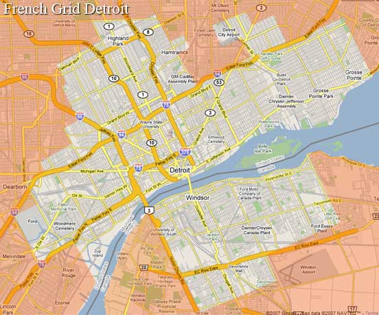 Does anybody know the history of the decision to go to the N-S-E-W grid -- when the French Meridian met the later set prime meridian of Base Line road. | ||
Scottr Member Username: Scottr Post Number: 172 Registered: 07-2006 |
quote: i just found this at http://info.detnews.com/histor y/story/index.cfm?id=199&categ ory=locations quote: | ||
Livernoisyard Member Username: Livernoisyard Post Number: 2198 Registered: 10-2004 |
I think I read somewhere that the funds for the Cass farm property came from his wife. $12,000 ($24/acre) back then was quite a bundle of cash. Later in 1895, the fancy mansions on Ferry cost about $14,000 to build, and the fanciest one cost about $70,000, if my flawed memory holds. [And its "pauper" neighbors hated having their mansions dwarfed by it.] If so, just who was Cass's wife? She probably was in one of the original lines of wealthy Detroiters. | ||
Jams Member Username: Jams Post Number: 4599 Registered: 10-2003 |
Short bio: quote: http://www.army.mil/cmh-pg/boo ks/Sw-SA/Cass.htm | ||
Scottr Member Username: Scottr Post Number: 174 Registered: 07-2006 |
From what i can tell, Cass's wife is from the family of Joseph Spencer, a General in the Continental Army and a delegate in the Continental Congress. Given that, I would not be surprised if she's from 'old money' and possibly did provide that 12 grand to purchase the farm. (Message edited by scottr on January 22, 2007) | ||
Mikem Member Username: Mikem Post Number: 2959 Registered: 10-2003 |
From Silas Farmer's "History of Detroit and Michigan": Portions of the tract now included in the Cass Farm were granted to Robert Navarre on May 1, 1747, and other portions, in 1750, to three several persons,-Messsrs. Barrois, Godet, and St. Martin. The Pontiac Manuscript shows that the person last named was occupying a portion of the farm in 1763. On March 20, 1781, it was purchased at auction of the estate of Jacques St. Martin by W. Macomb for Ł1060. About this time, twenty-four acres are said to have been added to the tract, without authority so far as is known. The tract now known as the Cass Farm embraces Private Claim No. 55, confirmed, by the United States Commissioners, to John, William, and David Macomb on November 16, 1807; and also Private Claim No. 592, which was confirmed to the same parties December 31, 1808. The occasion of the transfer to Governor Cass was as follows: The ordinance of 1787, and Acts creating subsequent Territorial Governments based on that ordinance, required the governor to be a freeholder to the extent of at least one thousand acres of land. Governor Cass, in order to conform to this law, after he had brought his family from Ohio, purchased of the Macombs in 1816 the farm which has since borne his name, and about the same time bought a large tract near the mouth of the river. The front of the farm was originally a very high bank, the river coming up to where stores are now located at the intersection of Jefferson Avenue and Second Street. The bank was dug away and the streets graded in 1836, twenty-five thousand cords of earth being removed. In September and October of that year lots on the "Cass front," embracing that part of the farm between Lamed Street and the river, were offered for sale at auction, the entire tract having previously been sold to a company of ten persons for one hundred thousand dollars. The property was then so far away from the center of the city that the lots would not sell, and after spending a large amount of money in improvements, the majority of the original purchasers were very glad to have General Cass take back the property at the price they had originally agreed to pay. | ||
Horn_wrecker Moderator Username: Horn_wrecker Post Number: 19 Registered: 08-2006 |
That area north of Grand Blvd was part of the 10,000 Acre Tract, up to the HP border. There was a thread awhile back about it. It looks like I'll have to copy and paste that 1796 map at NOAA, and PS it into a postable format. Yuck. | ||
Lowell Board Administrator Username: Lowell Post Number: 3591 Registered: 10-2003 |
quote:^^Pointing out the essentially anti-democratic aspects of the early years of this country. Of course women were also excluded among others. No wonder Cass was so wealthy, buying the farm for 12K then flipping the lower end for 100K 20 years later. It sounds like the crash of 1837 brought it back to Cass for the same price but with all the improvements. Presumably he resold it for a higher price later? | ||
Irish_mafia Member Username: Irish_mafia Post Number: 698 Registered: 10-2003 |
We had a ribbon farm, I believe around Bishop Road in GP, that somehow was connected to our family. Some great great aunt I believe was raised by an injun there....have to consult the family historian for better detail. | ||
Krawlspace Member Username: Krawlspace Post Number: 292 Registered: 04-2004 |
I live off Cadieux Road, on what was once the ribbon farm of Michael Cadieux. It had been mentioned on the boards before, but as I didn't see it mentioned in this thread I thought I'd post. The last workers house Michael Cadieux built for his tenant farmers around 1895 still stands just off the corner of E. Warren and Cadieux. A cool cat bought the place about 5 or 6 years ago and really cleaned up the property, including a new metal roof. If you've never been by there, check it out, and don't forget to stop in the Cadieux Cafe a block down the road for a bucket-o-mussels. | ||
Mikem Member Username: Mikem Post Number: 2960 Registered: 10-2003 |
A brief history of "my" ribbon-farm: Here's the relationship between the early private claims of the area, the Ten-Thousand Acre tract (the first land granted by the United States), and the township system (grid pattern) introduced by the Northwest Ordnance: 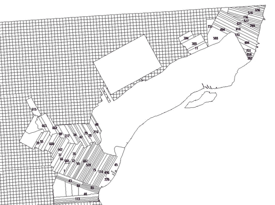 I live in what was private claim #618, granted Thomas Forsyth: 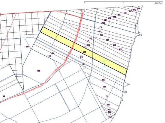 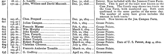 I have the old-fashioned title abstract for my house, which traces the history of ownership back to Forsyth: 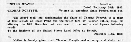 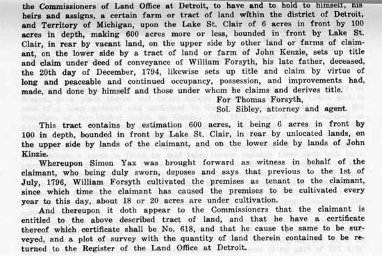 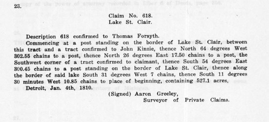 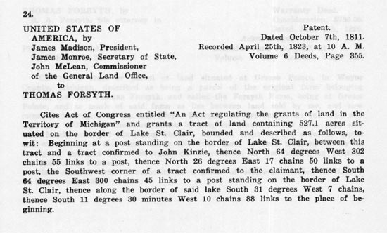 ...and on it goes for a hundred pages to the present day. It was sold in 1823 to Pere Bourgais dit Provencalle (Provencal Road). His daughter, Catherine Provencal Weir (Weir Road), inherited it in 1869. It existed as the Weir farm until the turn of the century: 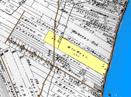 ...until she lost it in a foreclosure sale in 1898. After lengthly legal battles and several changes in ownership, it was acquired by the Country Club of Detroit in 1911. They sold the western end to a developer who subdivided it into the present day lots in 1926. | ||
Hornwrecker Member Username: Hornwrecker Post Number: 1737 Registered: 04-2005 |
Here are a few enlargements from the 1796 French map from the NOAA historical map section that I linked to above. It took awhile to get them done, as I can only view them in an IE plugin, and then do a print screen into PS, adding an extra step into it. The first is of the general Detroit-Windsor area at that time. 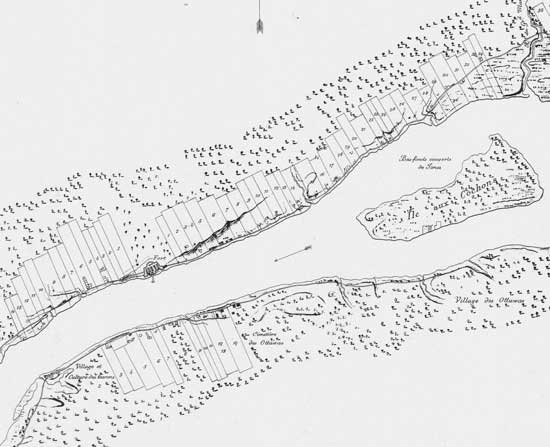 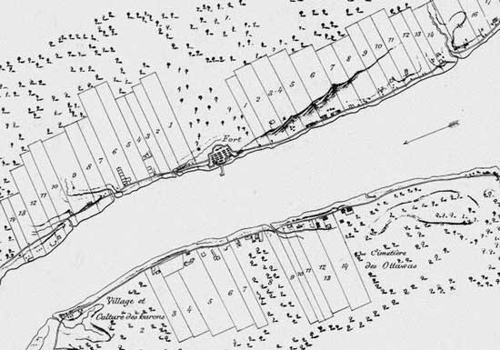 This is a table listing French farmers along with the number farm plot. 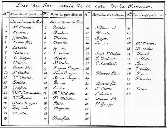 The same type of table for the Windsor area 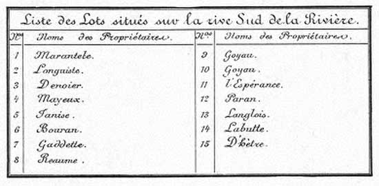 An enlargement of the Grand Marais area 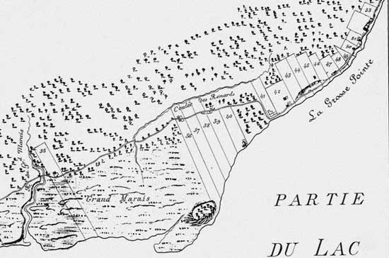 | ||
Kathleen Member Username: Kathleen Post Number: 1910 Registered: 10-2003 |
Grosse Pointe Historical Society's monthly program for April will address life on the ribbon farms. "April 14, 1-4pm - Life on the Ribbon Farm. Learn about the old Grosse Pointe Ribbon Farms. Learn to make butter and biscuits from scratch and enjoy homemade lemonade with Marguerite Humes." Free admission; reservations encouraged. Provencal-Weir House, 376 Kercheval Ave., Grosse Pointe Farms, Michigan 48236, phone: 313.884.7010. (Message edited by Kathleen on February 02, 2007) | ||
Kathleen Member Username: Kathleen Post Number: 1968 Registered: 10-2003 |
The Detroit Historical Museum has put together a series of lesson plans for teaching early Detroit history. Here's the one on the ribbon farms: http://www.detroithistorical.o rg/learningcenter/curriculumma terials/detroitsstory/b2.pdf | ||
Aarne_frobom Member Username: Aarne_frobom Post Number: 46 Registered: 10-2005 |
U.S. coast and geodetic survey maps (topographic maps) make it pretty clear where the old French long-lot farms were, and where they meet up with the section lines of the Northwest Ordinance. The maps contain the numbers of the larger lots. It is interesting to see the odd parcels created where the two systems meet, as in the summary map posted by Mikem above. | ||
Kathleen Member Username: Kathleen Post Number: 2046 Registered: 10-2003 |
Krawlspace: That workers house you mentioned...wasn't that once called The Kennary Kage and used for an antiques shop? | ||
Jeff_of_dayton Member Username: Jeff_of_dayton Post Number: 1 Registered: 03-2007 |
Hello! I am not from Detroit but visited there recently. I was curious about the French presence & did a google search on Detroit ribbon lots, came up with this thread. I noticed when I was there all the French street names east of downtown, like Riopelle, Beaubien, St Aubin, St Antoine, Chene, etc, and figured these might have been the names of the ribbon farm owners. Doing some websearches on Detroit maps it seems these lots were quite narrow! Perhaps they where subdivided between family members, hence became narrower over time? A question I had was how far back where they cultivated? On the old maps they look to extend pretty far back from the river for farms, but I am guessing they where not actually farmed that far in. Another question if there is any surviving French structures from the colonial period, such as perhaps an old farm cabin or house? | ||
Livernoisyard Member Username: Livernoisyard Post Number: 2776 Registered: 10-2004 |
Much of them lived in the fort, as farmers in Europe typically live in villages. The Indians there were not all friendly to the early French. The houses on those farms were often small log cabins--much like sheds, I'm told. They used the river as a "highway" and probably farmed them by day, but at night, they returned to the safety of the fort for several decades. | ||
Gistok Member Username: Gistok Post Number: 3800 Registered: 08-2004 |
Welcome Jeff_of_dayton! Nothing exists of the first 125 years of Detroit's history... that is from 1701 to 1826. The oldest extant building is the 1826 Trowbridge House. I think that parts of one of the old 1700's houses (Moross or Moran?) exists as a fragment in the Detroit Historical Museum. | ||
Patrick Member Username: Patrick Post Number: 4143 Registered: 10-2003 |
Are ribbon farms somewhat unique to the Detroit area? I know there had been farming communities up and down the St. Lawrence but many were not thin strips of land….or were they? | ||
Kathleen Member Username: Kathleen Post Number: 2076 Registered: 10-2003 |
Long, skinny ribbon farms are not unique to Detroit, but maybe to the French settlers in the New World.... Here's some info about the settlement along the St. Lawrence River: "...This rural community was built and based along the central reaches of the broad St. Lawrence River, that provided it with vital transportation and valuable fishing at the same time. Hence river-frontage was all-important; and farm-lots extended back in long narrow strips from the great waterway. Dotted along the river-front as they were, the sturdy farmhouses thus gave the impression of "one continued village" from below Quebec to Montreal -- so described by the visiting Swedish botanist, Peter Kalm, in 1749. In time, another range (and more) of farm allotments rose behind the original waterfront properties. But the pattern of ribbon-farms, within long, narrow seigneuries oriented to the St. Lawrence, would last long after New France: as maps or an air flight above the region can still reveal today. ..." Source: http://www.canadianheritage.or g/books/canada3.htm | ||
Jeff_of_dayton Member Username: Jeff_of_dayton Post Number: 4 Registered: 03-2007 |
I believe there are some near Vincennes, Indiana, which was a small French settlement. They existed in St Louis to some extent, too, though there was also Spanish land grants there. | ||
Jimaz Member Username: Jimaz Post Number: 1711 Registered: 12-2005 |
Ha! I was just wondering if they would have existed in New Orleans. Can't get much more French than that. The Mississippi River twists about so much down there that I doubt ribbon farms were ever even tried. | ||
Bulletmagnet Member Username: Bulletmagnet Post Number: 162 Registered: 01-2007 |
I've read through this thread a number of times now. I would just like to applaud all of the contributors for the valuable local history lesson. Thanks! | ||
Newport1128 Member Username: Newport1128 Post Number: 25 Registered: 05-2007 |
My wife's maiden name is Champine. She traced her ancestry back to the 1600's, and her ancestors were some of the early settlers along Lake St. Clair. Anyone know if there was a Champine ribbon farm? Twelve Mile Road was once called Champine Road, and there's a Champine Park now near the foot of 12 Mile and Jefferson. | ||
Patrick Member Username: Patrick Post Number: 4464 Registered: 10-2003 |
Most of east-west roads with French names were the boundaries for ribbon farms. I wouldnt be surprised if there was a Champine farm along 12 Mile. |