Ookpik Member Username: Ookpik Post Number: 1 Registered: 01-2007 |
Hello, Some of you may recognize my name. In brief, I have a collection of over 10,000 photographic images. About 75% are from Detroit. I have spent over 3 years trying to identify all of the images but some remain unidentified. I hope that will be allowed to post various images and ask for your assistance in identifying them. Without further a-do, here is the first image: 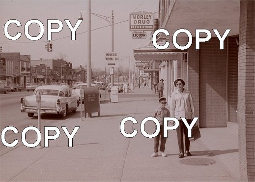 A larger version can be seen here: http://www.geocities.com/ookpikblogz/detpic5.jpg Thanx! Ookpik | ||
Smogboy Member Username: Smogboy Post Number: 4377 Registered: 11-2004 |
Even with the larger pic, I'm trying to make out what restaraunt that is in the distance. The Morley Drug sign is relatively generic. Grrrr... I wish I could help out more but none of the landmarks look familiar enough with me. It does look a little like downtown Farmington though but that's a wild guess at best. | ||
Dabirch Member Username: Dabirch Post Number: 2066 Registered: 06-2004 |
Mayberry? | ||
Lilpup Member Username: Lilpup Post Number: 1630 Registered: 06-2004 |
I know that Municipal Parking Lot sign from somewhere I *think* it's Main St. in Royal Oak | ||
Traxus Member Username: Traxus Post Number: 46 Registered: 02-2006 |
I second smogboy, it does look vaguely like downtown Farmington. Then again Farmington is pretty generic in itself. | ||
Jrvass Member Username: Jrvass Post Number: 20 Registered: 01-2007 |
I'm guessing Ferndale. Any chance you can zoom in on the restaurant sign? James | ||
Dodgemain Member Username: Dodgemain Post Number: 134 Registered: 04-2005 |
judging by the shadow, it looks like a east-west street | ||
Jimaz Member Username: Jimaz Post Number: 1416 Registered: 12-2005 |
The streetlight design might help. The fact that the municipal parking lot is off an intersection with a street light might help. The unique silhouettes of the southern storefront façades might help. | ||
Livernoisyard Member Username: Livernoisyard Post Number: 2238 Registered: 10-2004 |
Looks like no trees on the north side of the street, but there might be a tree or two on the south side. Traffic light intersection and a fireplug on the NW corner. Still should be that way today, but that's also generic. (Message edited by LivernoisYard on January 24, 2007) | ||
Lilpup Member Username: Lilpup Post Number: 1631 Registered: 06-2004 |
My other guess was Nine Mile in Ferndale but I can't recall there ever being a theater on Nine Mile and that street isn't wide enough to be Woodward | ||
Ookpik Member Username: Ookpik Post Number: 2 Registered: 01-2007 |
I enlarged the photo. You can read the restaurant sign but I can't quite figure out what its says. It looks like "Berouts" or "Berodts" or ? There is a movie theater beyond the restaurant. Thanks to all that have replied. I'm guessing the one thing that we can conclude is that this is not Detroit? Here is an enlarged view of the photo: http://www.geocities.com/ookpi kblogz/detpic5b.jpg Ookpik | ||
Dodgemain Member Username: Dodgemain Post Number: 135 Registered: 04-2005 |
I'm thinking Michigan and Schaefer looking westbound. | ||
Livernoisyard Member Username: Livernoisyard Post Number: 2239 Registered: 10-2004 |
My uncle John ran the newspaper/magazine stand on Michigan and Schaefer up until around 1950, so I would definitely recognize that corner. If Mich-Sch., it could be that stretch between Neckel and Maple (~137xx Michigan). Neckel is the street/alley leading to the Kroger's on Schaefer and the city parking lot. But Mich-Schaefer is a good possibility for now. A city directory from the late 1950s would come in handy... BTW, the website for the enlargement is unusable due to excessive usage on its account... A theater would seem to rule out this location, though as I don't remember one being there when I lived in Dearborn during the summer of 1958. Also, there is a jog in Maple Street at Michigan where the traffic signals are. Therefore, that might explain why the traffic lights are oriented the way they are. (Message edited by LivernoisYard on January 24, 2007) | ||
Bearinabox Member Username: Bearinabox Post Number: 105 Registered: 04-2006 |
If it was Farmington, wouldn't the light be much closer to the theatre and on the other side? The houses behind the Marathon don't look right for Farmington either. | ||
Jimaz Member Username: Jimaz Post Number: 1417 Registered: 12-2005 |
Bummeroni with cheese: quote:Must be a popular contest!  | ||
Lilpup Member Username: Lilpup Post Number: 1632 Registered: 06-2004 |
piece of 1st Federal Savings __land sign on the left edge street sign is just above the old man if you have a greater resolution image | ||
Jrvass Member Username: Jrvass Post Number: 21 Registered: 01-2007 |
Lilpup... I was thinking the same thing! James | ||
Digitaldom Member Username: Digitaldom Post Number: 566 Registered: 08-2004 |
I would say Royal Oak to be honest.. before woodward was moved.. | ||
Rickinatlanta Member Username: Rickinatlanta Post Number: 25 Registered: 07-2006 |
Where might your collection of Detroit photos be viewed? | ||
Ookpik Member Username: Ookpik Post Number: 3 Registered: 01-2007 |
The collection has yet to be digitized, however, a few of the pictures appear here: http://ookpiksnegz.blogspot.co m/ and also here: http://vintagemichigan.blogspo t.com/ Ookpik | ||
Mikem Member Username: Mikem Post Number: 2967 Registered: 10-2003 |
Ookpik, I love your site. Don't know if you caught it, but I identified a couple of those negatives back in July; one as the foot of 1st Avenue, and the following one as Madonna College. In this one I can see a railroad crossing and a Marathon station in the background. I'm working on it... | ||
Tiorted Member Username: Tiorted Post Number: 36 Registered: 02-2006 |
just a guess, but it looks kinda like 12 mile in Berkely | ||
Ookpik Member Username: Ookpik Post Number: 4 Registered: 01-2007 |
Hi Mike! I just read your comments yesterday! Thanks so much for identifying the photos! Ookpik | ||
Lilpup Member Username: Lilpup Post Number: 1634 Registered: 06-2004 |
Tiorted was/is there a municipal parking lot north of Twelve Mile? I vaguely remember right behind the theater or was that just off alley parking? | ||
Sticks Member Username: Sticks Post Number: 189 Registered: 08-2005 |
There is/was a theatre on Schaeffer north of Michigan, on the NE corner. However, that would mean the building she's standing next to would be made in terra cotta, which doesn't seem to be the case. | ||
Gistok Member Username: Gistok Post Number: 3486 Registered: 08-2004 |
Could it be Rochester? The street is wide enough to be Rochester Rd. And they also have off street Municipal lots. | ||
Mikeg Member Username: Mikeg Post Number: 489 Registered: 12-2005 |
Hi Ookpik, I can tell you that it's definitely not Center Line ;-) but that doesn't narrow it down very much, does it? All I can do is offer some observations and educated guesses. Lilpup wrote, "piece of 1st Federal Savings __land sign on the left edge" Seems to me I remember when the ones in Oakland County were called "1st Federal Savings Oakland". Notice also how the area near the Marathon gas station and railroad crossing appears to be lower in elevation than the areas in the distance, which suggests to me that the road crosses a river near the railroad. Based on the bare trees in the distance, the ~45 deg. elevation angle of the sun and the NOAA Solar Position Calculator, this photo was most likely taken along a north-south street at about 2 or 3 PM in late March or early April. | ||
Thecarl Member Username: Thecarl Post Number: 1005 Registered: 04-2005 |
looking down the street, is that a movie marquis beneath the horizon of the "restaurant" sign? if so, that would have to be a clue! | ||
Gsgeorge Member Username: Gsgeorge Post Number: 96 Registered: 08-2006 |
Rochester seems like a good bet, but I feel like I'd recognize at least one of those buildings if it were. A crazy guess but maybe Grand River and Greenfield? Utica? | ||
Smogboy Member Username: Smogboy Post Number: 4379 Registered: 11-2004 |
It looks like a three lane road with parking on both sides of the street. Now granted this is an old photo, but I think it might be too tiny for Grand River & Greenfield and too big for Utica's downtown. The mystery deepens! | ||
Ragtoplover59 Member Username: Ragtoplover59 Post Number: 42 Registered: 09-2006 |
Mikeg, "The Position Calculator" looks to be one fine tool, But I'm not sure it's set correct. At that time of day the Child should of been in school, Unless it's the weekend. But then I was wondering how could he (the Child) keep his Pants and Shoes so clean that late into a weekend day? I never could. I also would think that the lady would be holding some Bags from shopping, But I dont think she's made any purchases yet? except maybe Breakfast back down the street. And The Gentleman behind them seems to be waiting to buy some Prescriptions or Liquor, But can't seem to get in just yet? Other then I'm Sure the light is Green, The rest is just speculation on my part, Sorry it is of no help in the location of the area. That Pic and the others posted on the site above are fun to look at, Hope to see more! Just having Fun, It's late. Rag | ||
Toolbox Member Username: Toolbox Post Number: 1023 Registered: 10-2003 |
My guess is Rochester. Looking north just south of 4th and Rochester, standing in front of Mitzelfeld's. The building just across the side street look like the Masonic Lodge. | ||
56packman Member Username: 56packman Post Number: 934 Registered: 12-2005 |
It's not Farmington and it's not Grandriver-Greenfield. I was thinking Rochester, I'd agree with toolbox. I'll look up the movie theatre in the Andrew Craig Morrison book tonight. | ||
Toolbox Member Username: Toolbox Post Number: 1024 Registered: 10-2003 |
Low building with Bar sign is Mr. B's, going south is/was Baskin Bobbins, Symar lock and Key, Heller's Jewelers, Bank, and out of picture is the tux shop and then the 5 and dime now Andiamo. Pack, there were 3 theaters in downtown Rochester. Two on the east side and 1 on the west. The one on the west side was gone by the time that picture was taken. The building that the Varsity Shop was in was a theater. | ||
Scottr Member Username: Scottr Post Number: 180 Registered: 07-2006 |
toolbox is right - that theater is the hills theater on main. if you look at the picture here http://waterwinterwonderland.c om/location.asp?ID=1128&type=5 then compare it to the large version of the pic, you can just make out the HILLS sign on top of the marquee, behind the restaurant sign. nice challenge, i look forward to more of these. (Message edited by scottr on January 25, 2007) | ||
Scottr Member Username: Scottr Post Number: 181 Registered: 07-2006 |
wow, in the half hour or so i was trying to figure that out, toolbox filled that in with all kinds of details. good job! | ||
Danny Member Username: Danny Post Number: 5445 Registered: 02-2004 |
That could be Downtown Wayne, MI. | ||
Schoolcraft Member Username: Schoolcraft Post Number: 86 Registered: 07-2005 |
Plymouth Road-Detroit | ||
Jeanofarc Member Username: Jeanofarc Post Number: 11 Registered: 12-2003 |
There was Morley drugstore in downtown Rochester. | ||
Rsa Member Username: Rsa Post Number: 1009 Registered: 10-2003 |
to give you a list of morley's to narrow down the search, try the burton historical collection in the main branch of the dpl. the keep copies of phone books since the invention of the phone. this could at least give you a starting point, then you could weed out the improbable ones... | ||
Schoolcraft Member Username: Schoolcraft Post Number: 87 Registered: 07-2005 |
That road does appear a bit hilly...further down. The facade looks familiar on left...at least the style..multi-level or cantilever?Not sure of term. The road is not angled parking so not completely sold on Rochester...Big house on street right after commercial buildings on left...these trivia pictures ruin me. Is it conclusively Rochester? | ||
Mikeg Member Username: Mikeg Post Number: 490 Registered: 12-2005 |
From all of the presented evidence, it's definitely downtown Rochester. The photographer was standing on the east side of Main St. (Rochester Rd.), just south of 4th St. and aiming north. On the enlargement (not currently available) just behind/below the restaurant sign, you can make out the word "Hills" on the theater marquee. The railroad crossing in the distance used to be located about 200 ft. south of the Main St. bridge over the Paint Creek. | ||
Gsgeorge Member Username: Gsgeorge Post Number: 99 Registered: 08-2006 |
I think Mike G is correct. These three buildings can be seen on the opposite side of the street in the original photo just above the first parked car. They stick out prominently among the other buildings and the staggered brickwork is identical. ps - Gistok was the first to get it. (Message edited by gsgeorge on January 25, 2007) | ||
Livernoisyard Member Username: Livernoisyard Post Number: 2242 Registered: 10-2004 |
Just about where was that railroad bed? Along or near Water Street? The redevelopment seems so total near there. Where did that track originally go? | ||
Toolbox Member Username: Toolbox Post Number: 1025 Registered: 10-2003 |
The railbed is still there on the west side of Rochester Road, it is called the Paint Creek Trail. On the east side find the Depot and the Rochester Elevator and follow it towards Bloomer park. From there it follows the barge canal to meet up to the Clinton River Trail. Most of the railbed near Bloomer and the old Parke Davis property has eroded into the river. The Wheel Truing Brake Shoe Company is right across the river from the trail. | ||
Livernoisyard Member Username: Livernoisyard Post Number: 2243 Registered: 10-2004 |
Before, on GoogleEarth, I followed what seemingly was the former railbed and it had this narrow trail appearance, heading NW or so, assuming I was on the right track. But I'm still confused. If that railroad crossing by the Marathon station was, reportedly, north in the photo, how come the railroad bed seems to be between Mill and South Streets--south of the photo site? Was there another railroad crossing at grade? Or was the photographer facing south when taking that picture? (Message edited by LivernoisYard on January 25, 2007) | ||
Schoolcraft Member Username: Schoolcraft Post Number: 88 Registered: 07-2005 |
damn. Yuz guys are good. | ||
Mikeg Member Username: Mikeg Post Number: 491 Registered: 12-2005 |
L'yard Here is a topo map showing both railroad lines. The crossing signal visible in the photo is for the line that ran northwesterly on the north side of town along the Paint Creek. 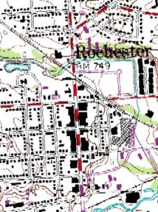 | ||
Gistok Member Username: Gistok Post Number: 3487 Registered: 08-2004 |
Do I win a prize? What's that... a $1000 gift certificate at Mitzelfeld's?  ... also redeemable at Jacobson's and Crowley's... (Message edited by Gistok on January 25, 2007) | ||
Livernoisyard Member Username: Livernoisyard Post Number: 2246 Registered: 10-2004 |
Great! The northerly rail bed is about where it should be expected to have been due to the orientation of the industry SE of its crossing with Main Street, near Water Street. | ||
Atl_runner Member Username: Atl_runner Post Number: 1957 Registered: 10-2003 |
Great Thread, and I second the 'you guys are good' comment. | ||
Ookpik Member Username: Ookpik Post Number: 5 Registered: 01-2007 |
Good? You guys (and gals?) are great! I fixed the link for the enlarged photo. It can be found here: http://www.geocities.com/engin ebarn/detpic5b.jpg Thanks for all your efforts in identifying the photo! Ookpik | ||
Ray1936 Member Username: Ray1936 Post Number: 1075 Registered: 01-2005 |
Photo was taken in 1963 or 1964. The Buick at the curb has a 1962 Michigan base plate with either a '63 or '64 validation tab. Both years tabs were dark (green in 63, brown in 64), so I can't tell which. 1965 saw a new plate issued. | ||
Toolbox Member Username: Toolbox Post Number: 1026 Registered: 10-2003 |
quote: The rail south of of town was at grade in the valley along the Clinton River and the north rail was at grade with the Paint Creek. The meet where the waters meet east of the south end of town. The south rail included a railyard on the west side of Rochester Road. Check this PDF From CULMA for a good areial of the area. | ||
Livernoisyard Member Username: Livernoisyard Post Number: 2251 Registered: 10-2004 |
The south rail was already under the viaduct by 1967. That's a similar setup to where I lived in WI, where an expensive highway bridge was placed over Allen Creek and a CNW railroad track and maybe five to ten houses nearby in Evansville, which used to be at grade. By 1967, it appeared that all of Rochester's rail crossings had bridges and AFAI can tell none were still at grade anymore. Also the former yard on the south was also gone--just a single track ROW. It seems that railroad rationalization occurred fairly early in Rochester, perhaps, fifteen years earlier than most places. | ||
Digitaldom Member Username: Digitaldom Post Number: 567 Registered: 08-2004 |
Yep I had to look at it again.. and yep it's rochester alright.. some of those buildings still exist today.. yeah until someone said rochester I didn't make the connection.. WOW.. good job guys! | ||
Digitaldom Member Username: Digitaldom Post Number: 568 Registered: 08-2004 |
I know this is a night photo.. but look at the outline of the buildings.. this is bit father down the street though... 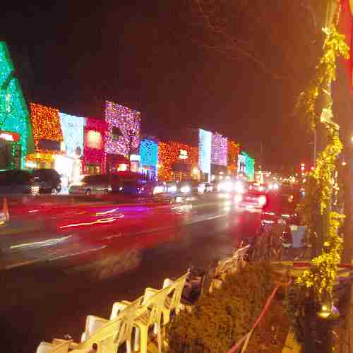 | ||
Toolbox Member Username: Toolbox Post Number: 1027 Registered: 10-2003 |
quote: The north rail was at grade till removal. The south rail was at grade with 1st Street and Mill Street in the valley. The south yard had about 8 tracks to it till the mid 80's. | ||
Livernoisyard Member Username: Livernoisyard Post Number: 2268 Registered: 10-2004 |
It looked on Google Earth that there might have been a lead to something near the building with the broadcasting tower SE of Rochester. What broadcaster is that? And was there some rail drop there at one time? It appeared that there might have been some kind of small RR bridge there too--probably a marsh near the river? |