Ookpik Member Username: Ookpik Post Number: 6 Registered: 01-2007 |
Thanks to everyone who worked to identify the previous photo. Your efforts are greatly appreciated. Here is another photo: 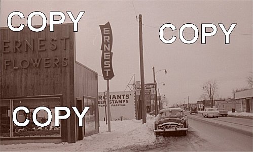 A larger version of the photo can be found here: http://www.geocities.com/enginebarn/detpic8.jpg Ookpik | ||
Ray1936 Member Username: Ray1936 Post Number: 1079 Registered: 01-2005 |
The parking restriction signs are similar to the fonts and wording used within the City of Detroit. I'm betting this location is in the city proper. And that's a fine looking Packard at the curb. | ||
Esp Member Username: Esp Post Number: 18 Registered: 09-2005 |
This reminds me of 11 Mile in Berkley around Coolidge. | ||
Livernoisyard Member Username: Livernoisyard Post Number: 2258 Registered: 10-2004 |
Notice all the empty lots. It resembles Detroit more than Berkley, especially from fifty years ago. Some of those buildings look new in the 1960s whereas some seem some twenty or so years older. The time frame for these photos are probably when the city of Detroit was still at or near maximum population status. Yet, there's those empty lots so indicative of Detroit's emptying--even back then. Agreeing with the following poster, I too think east side. I ride the SMART 510 to Macomb County on some softball mornings to Center Line. Somehow, this reminds me how Van Dyke might have looked before its vacant lots took over near City Airport. Florists are often located near cemeteries. There are at least two of those off Van Dyke. (Message edited by LivernoisYard on January 25, 2007) | ||
Jerome81 Member Username: Jerome81 Post Number: 1271 Registered: 11-2003 |
I'm no expert, but I'm hunchin this is eastside somewhere. Don't know why, just my feeling. | ||
Lilpup Member Username: Lilpup Post Number: 1641 Registered: 06-2004 |
well, the one empty lot I see looks like it's not plowed Can this be made bigger without losing resolution? There's an advertisement to the right of the tow truck and another business down from the Merchants' Green Stamps store. (Message edited by lilpup on January 26, 2007) | ||
Jjaba Member Username: Jjaba Post Number: 4777 Registered: 11-2003 |
Looks like Puritan deep on the Westside. jjaba. | ||
Hornwrecker Member Username: Hornwrecker Post Number: 1738 Registered: 04-2005 |
To me it looks a lot like east 7 Mile. | ||
Smogboy Member Username: Smogboy Post Number: 4387 Registered: 11-2004 |
My guess is that it's 11 Mile Road in Royal Oak, just west of Campbell- facing west. The Merchants Green Stamps sign looks vaguely like the Chicken Shack sign of today. The width of the street looks right too. Any help? Yes, no?? | ||
56packman Member Username: 56packman Post Number: 939 Registered: 12-2005 |
John R, south of 8 mile? nice '51 Packard | ||
Walterwaves Member Username: Walterwaves Post Number: 17 Registered: 01-2007 |
looks like Dequindre (did I spell that right?) to me some where around 6 -7 mile. | ||
The_rock Member Username: The_rock Post Number: 1511 Registered: 11-2003 |
Ernest Chiles in a floral designer in Beaufort, North Carolina. That's a LONG way from Puritan, jjaba. But if Ernest is the one and the same, there is more snow in Beaufort than I ever thought. You have TarHeel roots Ookpik? | ||
Livernoisyard Member Username: Livernoisyard Post Number: 2261 Registered: 10-2004 |
A web search came up with a florist shop called Ernest Flowers today in PA. | ||
Norwalk Member Username: Norwalk Post Number: 18 Registered: 11-2006 |
a "senior" 51 packard to boot! | ||
Queensfinest Member Username: Queensfinest Post Number: 7 Registered: 08-2006 |
Royal Oak, just north of where all of the larger condo and other development has been around Main St.? Towards Clawson. | ||
Tiorted Member Username: Tiorted Post Number: 38 Registered: 02-2006 |
feels like the west side to me. other than that I have no idea | ||
Schoolcraft Member Username: Schoolcraft Post Number: 89 Registered: 07-2005 |
Seems to me someone could get this but only with knowing history/location of Ernest Flowers and possibly Merchants. The only clues to me in this. Could be any number of streets but I lean toward puritan McNichols or & 7 mile....no vacant lots...those are parking lots for businesses/ buildings, no?. And this is a color photo that time of year. Amazing.(Kidding) | ||
Livernoisyard Member Username: Livernoisyard Post Number: 2263 Registered: 10-2004 |
Merchants Green Stamps must have been a Detroit thing because some nostalgia blogs link Merchants with Detroit's Faygo from the 1950s and 1960s. Merchants Green Stamps was owned nationally by Food Fair headquarted somewhere in the East--Richmond?. It's possible that the Merchants store was a redemption center for exercising the option of taking goods instead of cash for those filled stamp books. I somehow have a very distant recollection of those types of stores back in Milwaukee during the 1950s, possibly later, when there were other chain stores back in the long-gone Robert Hall days. But no Merchants Green Stamps ever were in M'waukee, AFAIK though. One uncle of mine owned commercial property near 6 Mile and Livernois, and there were few lots for parking although there were some. It was more common once to have a number of adjoining lots converted into parking, such as what the phone company might do for its bill payers, etc. as well as providing space for nearby merchants. | ||
Leob Member Username: Leob Post Number: 86 Registered: 10-2005 |
Check your city directories for these businesses c. 1951 > 1958 | ||
Ookpik Member Username: Ookpik Post Number: 7 Registered: 01-2007 |
Here is an enlarged version of the photo: http://www.geocities.com/engin ebarn/detpic8b.jpg As for having Tar-Heel roots - Nope - I was born in Detroit.  Ookpik | ||
Cambrian Member Username: Cambrian Post Number: 537 Registered: 08-2006 |
It does look like McNichols or 7 mile on the west side. There were / are a bunch of those single story 40s construction retail buildings there. As opposed to Fenkell or GR which has more double story 1910s an 20s type construction. I go to Knudesen's Bakery for the family B-day cakes and that area looks just like the one in the pic. | ||
Livernoisyard Member Username: Livernoisyard Post Number: 2266 Registered: 10-2004 |
6 Mile is the arbitrary division of Detroit into upper and lower class. North of 6 Mile meant more money. | ||
Mikeg Member Username: Mikeg Post Number: 497 Registered: 12-2005 |
I did an enlargement and it looks like there is a "Farm Maid" milk depot a little farther down the street: 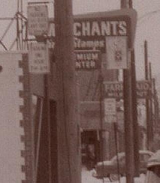 (Message edited by Mikeg on January 26, 2007) | ||
Livernoisyard Member Username: Livernoisyard Post Number: 2267 Registered: 10-2004 |
Did Detroit have "milk depots" like the ones near the outskirts of Milwaukee during the 1940s or 1950s? They sold milk, bread, eggs, and produce (outside, in season). When strip malls and shopping centers arrived by 1955, they were mostly all gone. | ||
Mikeg Member Username: Mikeg Post Number: 498 Registered: 12-2005 |
Anyone who attended school in Metro Detroit during the 1950's and 60's will remember the pint cardboard cartons of "Farm Maid" milk that were sold from the machines in school or in the cafeteria. Farm Maid was the brand name used by the Detroit Pure Milk Company. I remember the "milk depot" stores run by Brickley Dairy and Brown Dairy in the small Macomb Co. city where I grew up in the 60's. I do not remember seeing "Farm Maid" stores, but I would be very surprised if they did not have them in Detroit during the 50's and 60's. | ||
Ray1936 Member Username: Ray1936 Post Number: 1080 Registered: 01-2005 |
I don't know where this is going to end up, but it sure is fun. Thanks a bunch, ookpik! | ||
Mikem Member Username: Mikem Post Number: 2969 Registered: 10-2003 |
Merchants' Green Stamps Co, 14333 Fenkell Farm Maid Dairy, 14430 Fenkell Hmmm, one of those must be a misprint (both odd or both even), but it appears you are looking west on Fenkell, just west of Hubbell. | ||
Mikem Member Username: Mikem Post Number: 2970 Registered: 10-2003 |
^^^ Just east of Hubbell | ||
Jjaba Member Username: Jjaba Post Number: 4778 Registered: 11-2003 |
MikeM, you are track. jjaba said Puritan but Fenkell sure as hell is nearby. Wrigley Stores gave Green Stamps. jjaba dispensed them at the W. Davison and Greenlawn store where he worked after school for 60 cents an hr. So did gas stations. Yes, there were redemption centers with displays of all merchandise, to be paid for by books of S&H Green Stamps. The local Detroit operation was a franchise of S&H. The notion of Six Mile Rd. being a separation between rich and working class is a bit strong. There are huge tracts of Detroit on the Westside South of Six Mile Rd. where there are big houses full of rich folks. jjaba's two-flat on Northlawn near Schoolcraft is not one of them. Love this thread. jjaba, Westside Old Timey Newsboy. | ||
Quozl Member Username: Quozl Post Number: 125 Registered: 07-2005 |
That would make it right down the street from Cooley HS. I think you got it Mikem. I use to go with mom to a redemption center but I thought it was up on Grand River. We use to drive down Fenkell to Schaefer Hwy all the time to some Italian place called Rina's Pizza across from the DSR Depot. | ||
Mikem Member Username: Mikem Post Number: 2971 Registered: 10-2003 |
Looking farther back in time, Farm Maid Dairy was previously Detroit Pure Milk Co. Their office was at 14430 Fenkell, and their store was at 14421 Fenkell. This explains the even numbered address above for Farm Maid Dairy. | ||
Jjaba Member Username: Jjaba Post Number: 4780 Registered: 11-2003 |
MikeM, you amaze us. Thanks. Ofcourse there were milk depots, several chains of them such as Detroit Creamery, Wilson Dairy, Johnson Milk Depots. jjaba knew it was Westside from the gitgo. MikeM confirms it. Wonderful work. We bought a step-stool and card table and chairs at S&H. jjaba was good at filling the books. Don't let the boxboy put the stamps in the grocery bag. They get all fucked up in the wet radishes. Better to stuff the damn things in your purse at check-out. It was like Chanukkah when you went to Green Stamps Store. Detroit had Gold Bell Gift Stamps also with that Westminster Chime advert on radio and tv. jjaba, Westside Bar Mitzvah Bukkor. | ||
65memories Member Username: 65memories Post Number: 334 Registered: 10-2003 |
These challenges are fun...keep doing them...maybe we can even compete for prizes ala the Jjaba contests. | ||
Schoolcraft Member Username: Schoolcraft Post Number: 91 Registered: 07-2005 |
Damn. And my mother went to Cooley. A son should call his mother more often.Mikem rules with Jjaba. Thought with streetlights on every corner it had to be "city". We went to an S and H near Greenfield/Southfield I thought.Bring it on Ookpik. | ||
Livernoisyard Member Username: Livernoisyard Post Number: 2269 Registered: 10-2004 |
The Gehl Dairy next to the large A.O. Smith Company in Milwaukee in the seven-mile long 30th Street Industrial Corridor (which made most of the chassis frames for Detroit and almost all the bomb casings for both world wars) was a few blocks from school. They sold hundreds of those cup-sized cartons of milk for a penny each during the 1950s. I bought two every morning. | ||
Cambrian Member Username: Cambrian Post Number: 539 Registered: 08-2006 |
Our favorite was to stomp on little 1/2 pint cartons when we finished the milk to get them to make a loud BANG. One time when I was in 1st grade at Detroit Children's School I saw one on the playground and seized my opportunity, there was a group of kids around. When I brought my foot down and compressed the container the side blew open and spewed rotten milk all over this other kid that standing nearby. Do kids still get their school lunch milk in those little half pints? | ||
Opus Member Username: Opus Post Number: 30 Registered: 08-2005 |
Yes the milk is still in the little half pints, and they still make that great bang when you stomp on them | ||
Jerome81 Member Username: Jerome81 Post Number: 1276 Registered: 11-2003 |
I think MIkeM is correct. And I think Ernest Flowers building still exists. Though if you look at satellite images, it appears the buildings on the north side of Fenkell have been razed sometime between the satellite picture and the 3d picture from live.com Quality of the road surface looked better way back when too... 3d view from live.com (view it towards the west): http://maps.live.com/default.a spx?v=2&cp=42.401747~-83.18796 5&style=o&lvl=2&tilt=-90&dir=0 &alt=-1000&scene=5632415 Satellite view showing buildings on north side no longer there: http://maps.live.com/default.a spx?v=2&cp=42.401838~-83.18815 5&style=h&lvl=19&tilt=-90&dir= 0&alt=-1000&scene=5632419 Wow. Keep this coming! | ||
Livernoisyard Member Username: Livernoisyard Post Number: 2271 Registered: 10-2004 |
So, is this a neighborhood that'll spring back to life after rapid transit comes on the scene? Personally, I'd like to transit through this hood as rapidly as possible myself. It's already got that Van Dyke "look & feel!" | ||
220hendrie1910 Member Username: 220hendrie1910 Post Number: 61 Registered: 02-2006 |
Hm, I think Jerome81 is off by one block to the west. If the address of 14333 Fenkell for the Merchants' Green Stamps store is correct, then it would be to the EAST of Mark Twain St., so if you follow his maps.live.com link and go one block east, that old building with the white van parked in front would be the Merchants' building - it even seems to have the same sign overhanging the sidewalk! Map-happy in Ottawa. | ||
Livernoisyard Member Username: Livernoisyard Post Number: 2273 Registered: 10-2004 |
Is it possible that (some of) the addresses are incorrect? Odd numbers are on the south side of the street. What I see for 14333 Fenkel appears to be a vacant lot (could have been the lot between the florist and the next store.) However, there is another building where the florist would be (different orientation and setback). The florist building appeared newer than most in the photo. So having it changed seems unlikely. If the numbers for the dairy and the store are correct, then they're both toast. There remain a set of buildings on Fenkel that through their rough appearance and orientation could have been the florist and the redemption center, but this set of buildings are on the north side of the street looking east from Hubbell. These, being further west by a block or two would have numbers larger than those of the others. | ||
Detroitej72 Member Username: Detroitej72 Post Number: 463 Registered: 05-2006 |
Our favorite was to stomp on little 1/2 pint cartons when we finished the milk to get them to make a loud BANG. ______________________________ ___________________ Hey Cambrian, I went to DPS in the late 70's and early 80's and we would stomp them behind the lunch-mother's backs in the hope they would jump. Unfortuneatly, they were well aware or our stunts, and promptly walked us down to the principle's office for a call to our moms! | ||
Livernoisyard Member Username: Livernoisyard Post Number: 2275 Registered: 10-2004 |
quote: Weren't you ever taught in grade school that the principal was your pal? | ||
Detroitej72 Member Username: Detroitej72 Post Number: 465 Registered: 05-2006 |
He!l F#&k NOOO!!! The first, and ONLY TIME I was walked down to "The Office", I begged my teacher to let me get spanked instead of calling home! | ||
Livernoisyard Member Username: Livernoisyard Post Number: 2278 Registered: 10-2004 |
So, is there some agreement as to exactly where the photo site actually was? Was it the north or south side of Fenkel? Was it near (east of) Mark Twain or was it just east of Hubbell on the north side of the street (would need to have an even address for this)? Was it possible that the Merchants Stamp redemption center might have moved nearby at some point? If on the north side of Fenkel, it would have been even addressed. Mike mentions looking west just east of Hubbell. How could this be with the addresses put forth so far? Those numbers then should be a few hundred blocks higher than any of those given... I'm leaning on the photo site being on the north side of the street just west of Hubbell facing east, but the numbers given so far don't agree. However, the building at the NE corner of the Hubbell intersection might have been the florist and the next building east could have been the Merchants Stamp place. The general shape and placement of those two fit the photos. Besides, if elsewhere, they're all or mostly all vacant lots today. | ||
Mikem Member Username: Mikem Post Number: 2976 Registered: 10-2003 |
LY, you are on the south side of Fenkell at Freeland, looking west. Merchants' Green Stamps = 14333 Fenkell, between Freeland & Mark Twain Farm Maid Dairy = 14421 Fenkell, between Mark Twain & Strathmoor. The automobile between the two stores is on Mark Twain. | ||
Livernoisyard Member Username: Livernoisyard Post Number: 2279 Registered: 10-2004 |
OK. Then the florist shop was demoed and whatever replaced it expanded onto the lot between the stamp redemption store. Apparently, the store (with the plate-glass front or whatever) across the street (north side) east of Mark Twain seems to be gone also. And the building west of Mark Twain apparently was also demoed and the site just west of that appears to be a convenience store/gas station, as evidenced by the large canopy. Or IOW, the neighborhood changed a lot. About the only structure remaining might be the stamp place, and there's no guarantee that even that is the same, but probably is. (Message edited by LivernoisYard on January 27, 2007) | ||
Jjaba Member Username: Jjaba Post Number: 4782 Registered: 11-2003 |
jjaba runs his own trivia contests. Keep looking, he might lay one on ya. jjaba. | ||
Mikeg Member Username: Mikeg Post Number: 508 Registered: 12-2005 |
I just came across this ad in the 1963 St. Clement High School Yearbook: Farm Maid Dairy 14430 Fenkle (sic) Detroit 27, Michigan VE-7-6000 Another ad from the same yearbook: Robinson Dairy Vending 11685 Mt. Elliot Detroit, Michigan Phone TW-3-0200 | ||
Chucktown_motown Member Username: Chucktown_motown Post Number: 39 Registered: 09-2006 |
There's always someone who say's "This looks like Northville st the Old Red Orchard Stop, this looks like Lathup Village on Schonnerr at Clamity Jane, This looks like Royal Coke at"....That's funny, were trying to find out where in "Detroit" this is. Not Macomb Twp. I mean who claims, "Yo' I represnt Macomb Twp" or the "I reperesnt Bingham Farms what"...Eh' buddy "Lake Orion up!"......... LAter, You know them hardcore streets of Clarkson boyyyyyyyyy! | ||
Toolbox Member Username: Toolbox Post Number: 1029 Registered: 10-2003 |
quote: Except one of the pictures was of Downtown Rochester. Last time I checked that was about 20 miles north of Detroit. |