Ookpik Member Username: Ookpik Post Number: 47 Registered: 01-2007 |
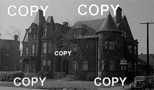 Fine old houses on McDougall. For a larger version of the photo, please click here Ookpik | ||
Kathleen Member Username: Kathleen Post Number: 1949 Registered: 10-2003 |
Trying to read the cross street...maybe Arndt? If it is, that would place us on McDougall below Gratiot and a block north of Charlevoix. Who can confirm what that street sign says? | ||
Mikeg Member Username: Mikeg Post Number: 579 Registered: 12-2005 |
I'm not sure what it says, even after enlarging it: 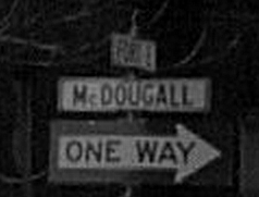 However, it does look like the last letter is an "E", as in "East". | ||
Missnmich Member Username: Missnmich Post Number: 560 Registered: 11-2004 |
It looks like Fort E. | ||
Psip Member Username: Psip Post Number: 1387 Registered: 04-2005 |
Fort on the east side was renamed Lafayette sometime in the 30s. | ||
Nativegirl Member Username: Nativegirl Post Number: 68 Registered: 01-2004 |
I am thinking the sign above and on the enlarged photo that the streets are Forest E and McDougal. | ||
Stryker81 Member Username: Stryker81 Post Number: 20 Registered: 10-2006 |
I keep seeing Ferry St. there. | ||
Mccarch Member Username: Mccarch Post Number: 104 Registered: 12-2003 |
Where's our man with his Sanborns? | ||
Swingline Member Username: Swingline Post Number: 709 Registered: 11-2003 |
quote:I'm not sure that's correct. I believe that Fort went through to the Mt. Elliot area. Essentially all of it was eliminated in the Lafayette Park/Elmwood Park urban renewal projects. I think that Fort Street bridge over the Dequindre Cut is still there. | ||
E_hemingway Member Username: E_hemingway Post Number: 1058 Registered: 11-2004 |
There is a house in Woodbridge, one block east of Trumbull, that looks an awful lot like the one on the left. | ||
Psip Member Username: Psip Post Number: 1388 Registered: 04-2005 |
I stand corrected, My 50+ year old brain cell fails sometimes. Heres a 1936 map of the area. 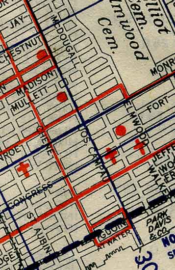 The red dot indicates a Public School location (Message edited by PSIP on February 15, 2007) | ||
Mikem Member Username: Mikem Post Number: 3045 Registered: 10-2003 |
E Fort was still E Fort on the eastside, separate from E Lafayette:  The floor plan on the Sanborn maps seem to match a house at 651 McDougall, southwest corner of E Fort & McDougall:  The picture looks like it's from the late 1930s, early 1940s. Probably a rental by this time in its life. Occupants of 651 McDougall in 1935: Jay S Griffin and his wife May; he was employed somewhere as a machinist. Next door at 645 McDougall was Anthony Maskili and his wife Antonina, occupation unknown. By 1940, 651 McDougall was now home to Albert Wilkinson and his wife Beatrice. Albert was a mechanic. Next door, the new tenants were Andrew Green, a laborer, and wife Elizabeth, and on a different floor, John King and his wife Annie. John was an autoworker. (Message edited by MikeM on February 15, 2007) | ||
Mikem Member Username: Mikem Post Number: 3046 Registered: 10-2003 |
Let's bring those houses out of the shadows so we can see a little more detail: 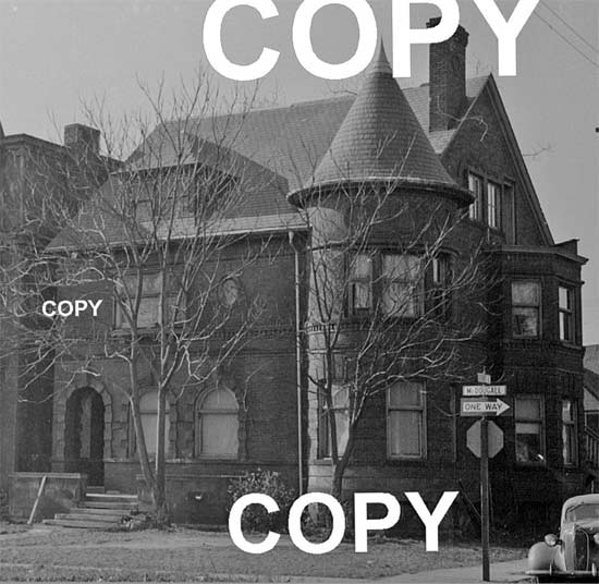 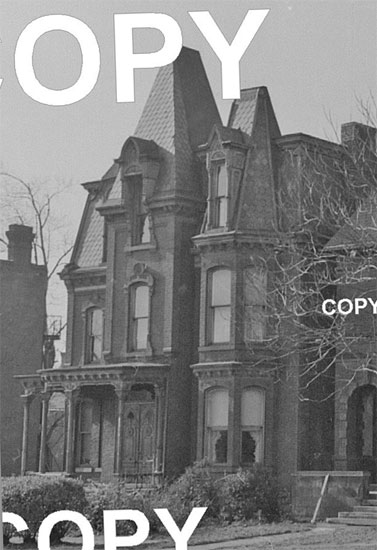 | ||
Psip Member Username: Psip Post Number: 1389 Registered: 04-2005 |
Interesting, there is still a 1 block section of Fort E between Mt.Elliot and Meldrum Street | ||
Mikem Member Username: Mikem Post Number: 3048 Registered: 10-2003 |
Today at McDougall and where E Fort would intersect - still rental housing:  | ||
Cambrian Member Username: Cambrian Post Number: 631 Registered: 08-2006 |
Those houses look too elaborate too be blue collar owned. | ||
Psip Member Username: Psip Post Number: 1390 Registered: 04-2005 |
Cambrian, I would suspect those homes were built in the 1850s. By the 1930's urban sprawl was taking the people who could afford that type of house were moving to Boston Edison and the Grosse Points. Remember that in the 20s Detroit was America's boom town. | ||
Cambrian Member Username: Cambrian Post Number: 632 Registered: 08-2006 |
Wow, too bad there are not many "reasonably" priced houses like that for us working guys today. | ||
Ookpik Member Username: Ookpik Post Number: 48 Registered: 01-2007 |
Wow! Right down to the house number! Thanx! I think the photo was taken circa 1949-1950. Look closely at the houses - they are boarded up. Probably abandoned and/or about to be torn down. Ookpik | ||
Psip Member Username: Psip Post Number: 1391 Registered: 04-2005 |
The cars are from the 30s, If the photo was taken after the war, I think a lot of those cars went into the war effort. I see curtains on some of the windows. The boarded up look could be reflections. Although the steps on the first house are pretty rough. (Message edited by PSIP on February 15, 2007) | ||
Ookpik Member Username: Ookpik Post Number: 49 Registered: 01-2007 |
Psip - You are right. The car in front appears to be a 1936 Chevrolet. Those are probably not boarded up windows but drawn shades. Ookpik | ||
Ray1936 Member Username: Ray1936 Post Number: 1138 Registered: 01-2005 |
The black lettering on white background street sign indicates after 1949. Prior to that year, the Detroit street signs were wood and were white letters on a black background. A major effort to replace all the signs took place in 1949, so I would guess that picture as no earlier than that, despite the '36 Chevvy. | ||
Ookpik Member Username: Ookpik Post Number: 50 Registered: 01-2007 |
Ray - that is very interesting information. I got the years of 1949 or 1950 from notes left by the original photographer. Ookpik | ||
Gistok Member Username: Gistok Post Number: 3645 Registered: 08-2004 |
If this picture is an indication of what was torn down to put up Lafayette Park and Elmwood... I'm gonna be sick.... | ||
Jams Member Username: Jams Post Number: 4771 Registered: 10-2003 |
Gistok, Drive Vernor to see what was in Black Bottom. I have to admit, I'm very intrigued by those "workman's cottages". | ||
Livernoisyard Member Username: Livernoisyard Post Number: 2545 Registered: 10-2004 |
Perhaps, the residents were retired or semi-retired and still listed their prior or part-time occupations. It was very easy to work anywhere back then on any kind of basis if one was good at what he did. Another thing, these types of city directories and such employed canvassers much like the Census Bureau does. Back during 1970 in Madison, both the CB and the city directory canvassers came to the large apartment where I supered while taking some courses at UW. The residents there "volunteered" all kinds of BS info about most of the other 50+ residents living there to both canvassers. | ||
Mikem Member Username: Mikem Post Number: 3052 Registered: 10-2003 |
That may be true but somehow I doubt anyone is bullshitting a canvasser that he's a "laborer". It's 1950, these were inner city houses, and they were most likely rentals since the depression. I bet if you looked through the Polk's for every year, you'd find a new name in each place every other year. I found these pictures in an old photo album. They were taken by my brother who was a student architect in the late 1960s. I think he may have even rented one of these houses for a short while. I believe these are all on E Jefferson near Jos Campau, just blocks away from McDougall and Fort: 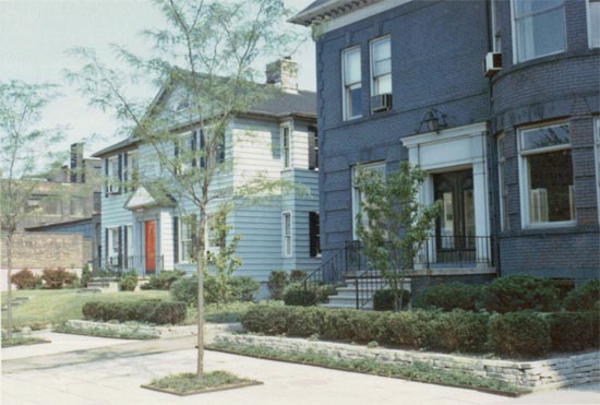      Can anyone tell the year by the cars? | ||
Ookpik Member Username: Ookpik Post Number: 51 Registered: 01-2007 |
Pic # 4 - 2-Tone car is most likely a 1961 Buick. Pic # 6 - 2nd car from right is a 1963 Mercury. Pix are most likely from 1963-1965. Ookpik | ||
Ray1936 Member Username: Ray1936 Post Number: 1139 Registered: 01-2005 |
Nice photos, Mike. We've destroyed some beautiful homes in our town, haven't we? Ookpik, yeah, those steet signs can be a help in figuring approximate years. The old wood ones were replaced in 1949, and the white ones were replaced with the current green ones starting about 1980. Here's a shot of the pre-1949 signs. 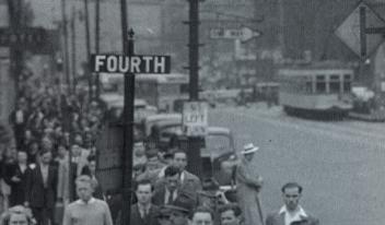 | ||
Kathleen Member Username: Kathleen Post Number: 1950 Registered: 10-2003 |
Well, I certainly recognize the Bagley House (left in the photos of the two houses with the turrets) and its next door neighbor, both still standing. Interesting to see that there was a service station where there is now a parking lot next to the Bagley House. (Message edited by Kathleen on February 15, 2007) | ||
56packman Member Username: 56packman Post Number: 999 Registered: 12-2005 |
The newest car (shown in picture#5 from the top) is a 1965 Pontiac, could be a Bonneville. the car on the right in the bottom picture looks just like my 1963 Chevy II 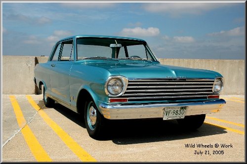 | ||
Mikeg Member Username: Mikeg Post Number: 581 Registered: 12-2005 |
The house on the corner was still standing in May of 1967. Its neighbor succumbed to the wrecker sometime between 1961 and 1967. 1961: 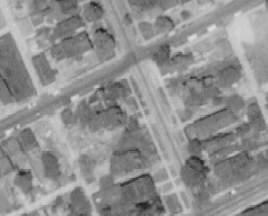 1967:  | ||
Deegee Member Username: Deegee Post Number: 36 Registered: 11-2004 |
Why were so many people on Fourth Street on that photo with the pre-1949 street sign? Was that just the normal amount of traffic? | ||
Bearinabox Member Username: Bearinabox Post Number: 109 Registered: 04-2006 |
They're not ON Fourth, Fourth is the cross street. | ||
Psip Member Username: Psip Post Number: 1395 Registered: 04-2005 |
going to a Tiger game? | ||
Ray1936 Member Username: Ray1936 Post Number: 1140 Registered: 01-2005 |
Wartime photo. They are going to the draft board office at 1040 W. Fort. From the book, "Historic Photos of Detroit", by Mary J. Wallace. | ||
Livernoisyard Member Username: Livernoisyard Post Number: 2551 Registered: 10-2004 |
quote: Is that where the Tigers drafted their players back then? | ||
Johnlodge Member Username: Johnlodge Post Number: 139 Registered: 10-2003 |
I would usually take this moment to make some sort of deragatory remark about the Tigers. But somehow that's just not as fun anymore... | ||
Bob_cosgrove Member Username: Bob_cosgrove Post Number: 465 Registered: 03-2005 |
Most of Fort Street on the east side of Detroi was removed in the 1950's with the development of the Layfayette Park area and housing to the east of the park - but a small section of East Fort still exists between Mt. Elliot and Beaufait. Fort was never Lafayette - the former name for Lafayette was Champlain until c.1930 or so. Vernor east of Woodward was High Street. Bob Cosgrovez | ||
The_rock Member Username: The_rock Post Number: 1575 Registered: 11-2003 |
Bob C.----I (We) need your help on Old Photo XI to identify that locomotive. I know what it's not, but not what it is.! |