Ookpik Member Username: Ookpik Post Number: 89 Registered: 01-2007 |
 I don't recognize anything in this photo. For a larger version of the photo, please click here Ookpik (Message edited by Ookpik on February 28, 2007) | ||
56packman Member Username: 56packman Post Number: 1045 Registered: 12-2005 |
your "please click here" link takes us to a previously posted photo, the one of the dam. | ||
Ookpik Member Username: Ookpik Post Number: 90 Registered: 01-2007 |
Dam! ;) Fixed! Click refresh if needed. | ||
Livernoisyard Member Username: Livernoisyard Post Number: 2653 Registered: 10-2004 |
Could that be near Third Street with the older railroad freight facilities behind/downstream? That's quite a pile of coal for the locomotives or power stations there. However, the skyscrapers in the background imply something on the East Side just upstream from a bend in the river. Perhaps, a clue might be contained in the DY banner... (Message edited by LivernoisYard on February 28, 2007) | ||
Fareastsider Member Username: Fareastsider Post Number: 163 Registered: 08-2006 |
I recognize the Guardian building I think I see the Penobscot and Cadillac Tower as well. | ||
56packman Member Username: 56packman Post Number: 1047 Registered: 12-2005 |
can we get a Sanborn map in here, stat? | ||
Kathleen Member Username: Kathleen Post Number: 1998 Registered: 10-2003 |
Fareastsider is right...definitely the Guardian and Penobscot Buildings in the distance; the 3rd might be the old Real Estate Exchange building (long ago razed). I'm thinking that the buildings at the extreme right of the photo may be part of the Parke Davis complex at the foot of Joseph Campau. | ||
The_rock Member Username: The_rock Post Number: 1593 Registered: 11-2003 |
I'd say it was taken looking downriver toward the downtown area, Uniroyal plant is shown and the Parke Davis facility is on the right side of the photograph. That looks like one of the old Browning boats tied up at the dock. The McCarthy boats use to tie up there too. | ||
Kathleen Member Username: Kathleen Post Number: 1999 Registered: 10-2003 |
Thanks, Bob. I should have recognized the Uniroyal Plant buildings! So the photo was likely take from the Belle Isle Bridge? | ||
Mikem Member Username: Mikem Post Number: 3130 Registered: 10-2003 |
Belle Isle Bridge looking downstream. U.S. Rubber on the far right. Next to it is an old gas plant of the Detroit City Gas Co. If the coal pile belongs to the gas plant, then the picture is pre-1940 (natural gas by pipeline from Kansas arriving in the city in 1936), otherwise it could be for the tire factory's power plant. The ship is probably tied up at the gravel company dock. I think the factory behind the ship is the Buhl Stamping Co. or a combination of Buhl and Parke Davis. Map from 1947: 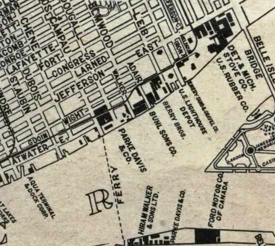 | ||
Ookpik Member Username: Ookpik Post Number: 91 Registered: 01-2007 |
Thanks for the map! If this photo was taken from the Belle Isle Bridge looking downstream, then yesterday's photos (Old Photo XX) must be looking upstream? The photo is probably pre-1940. | ||
Mikem Member Username: Mikem Post Number: 3132 Registered: 10-2003 |
Yes, yesterday's looking upstream. | ||
Schoolcraft Member Username: Schoolcraft Post Number: 106 Registered: 07-2005 |
Could it be a photo taken from the ferry from Belle Isle? The one that shuttles all those commuters(HEHE) If not mistaken, remember "Presumed Innocent" movie with Harrison Ford taking ferry from Belle Isle to go to work. Always got a chuckle from that. | ||
Bulletmagnet Member Username: Bulletmagnet Post Number: 61 Registered: 01-2007 |
Can any maritime fans tell us about the ship? |