Ookpik Member Username: Ookpik Post Number: 155 Registered: 01-2007 |
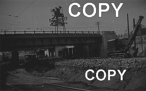 The original negative is kinda crappy hence I couldn't get that great of an image. Anyway, it looks like the Express Way is being built! But which one and where? I'm guessing the photo is from around 1947. For a larger version of the photo, please click here Ookpik (Message edited by Ookpik on March 26, 2007) | ||
Dnvn522 Member Username: Dnvn522 Post Number: 211 Registered: 11-2004 |
If it's mid 1940s, then it has to be part of the Davison Fwy. None of the others were built yet. | ||
Livernoisyard Member Username: Livernoisyard Post Number: 2915 Registered: 10-2004 |
Wasn't the Ford Freeway built up to Wyoming starting in 1942 and east of that after WWII? | ||
Ja1mz Member Username: Ja1mz Post Number: 24 Registered: 02-2007 |
Looks like an old I-94 overpass...just a guess | ||
Ookpik Member Username: Ookpik Post Number: 156 Registered: 01-2007 |
Here is a good site about the history of Detroit's Freeways: http://www.detroitrising.com/f reeways.htm | ||
Livernoisyard Member Username: Livernoisyard Post Number: 2917 Registered: 10-2004 |
The railroad ROW is a bit of a clue. If there was no parallel railroad track(s) nearby, then that cannot be the location. Some railroad tracks are quite near I-94 near Miller by the Rouge plant. I have a vague memory as a kid of some lit-up ads near I-94 north of the Rouge when visiting Dearborn most summers. However, I don't remember if they advertised beer or not. (Message edited by LivernoisYard on March 26, 2007) | ||
Fareastsider Member Username: Fareastsider Post Number: 273 Registered: 08-2006 |
My guess is 94 by West Grand | ||
Mikem Member Username: Mikem Post Number: 3216 Registered: 10-2003 |
The Pfeiffer brewery was at Mack and Beaufait. Of course the sign could be located anywhere around town. This could be a railroad underpass for a major street and not a freeway segment. 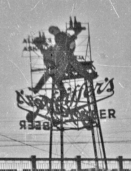 | ||
E_hemingway Member Username: E_hemingway Post Number: 1116 Registered: 11-2004 |
It kinda looks like the railroad bridge over Woodward at either Grand Blvd or up in Highland Park. There appears to be some space for a sidewalk under the bridge behind some columns in the background. | ||
Jman Member Username: Jman Post Number: 31 Registered: 10-2006 |
Davison freeway was completed in 1942. This picture is not Woodward and Davison. | ||
Psip Member Username: Psip Post Number: 1640 Registered: 04-2005 |
The Woodward widening project at Baltimore. Taken looking North from the West Maybe. | ||
Caldogven Member Username: Caldogven Post Number: 23 Registered: 05-2006 |
Ookpik- There was a Pfeiffer's sign on top of a building at Gratiot and Harper. Could this be the I-94 underpass at Gratiot, Pennsylvania, and Cadillac? That sign was amimated and looked like Johnny was marching and playing the fife. It also had music notes thet moved. | ||
Gistok Member Username: Gistok Post Number: 3913 Registered: 08-2004 |
It looks to me like one of the underpasses of Ford Rd. 1 mile west of Wyoming. | ||
Livernoisyard Member Username: Livernoisyard Post Number: 2919 Registered: 10-2004 |
I lived within a few blocks of Ford and Miller/Oakman. Other than the former track serving the Hartwell bus barn east of Hemlock Park, there would not have been a track at grade there during the 1940s. There others were placed above grade back around 1920. But again, one of those bridges--the one for the Detroit Terminal RR--has a 1948 date on its plaque. There is/was a tank farm near there. (Message edited by LivernoisYard on March 26, 2007) | ||
Psip Member Username: Psip Post Number: 1650 Registered: 04-2005 |
There are 2 bridges with a pedestrian walkway on the side. Here are some blow ups of the cars on the one side. Notice they the ground level is at the excavated level. On the other side, there is a retaining wall with letter INCL painted on it. Sinclair? 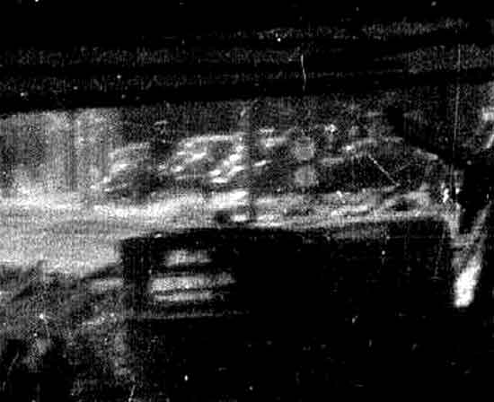 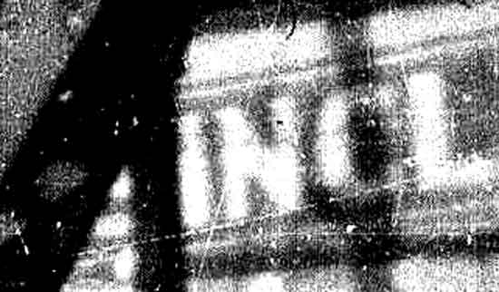 | ||
Ookpik Member Username: Ookpik Post Number: 158 Registered: 01-2007 |
I saw the INCL part and thought Sinclair too, however, if you look through the crane the letter does not look like an S. It kinda looks like an E. | ||
Gistok Member Username: Gistok Post Number: 3915 Registered: 08-2004 |
Well with pedestrian walkways it would mean that it is NOT a freeway bridge. I still think it's a Ford Rd. underpass. I drove by there on Thursday, and the Ford Rd. roadway is all torn up for replacement, so now it really does look like that picture! | ||
Psip Member Username: Psip Post Number: 1651 Registered: 04-2005 |
Just a guess, the 8 Mile RR Viaduct (I know,vi-not a chicken) by Woodward. I have been looking at the 1949 DTE photomaps and its a maybe. 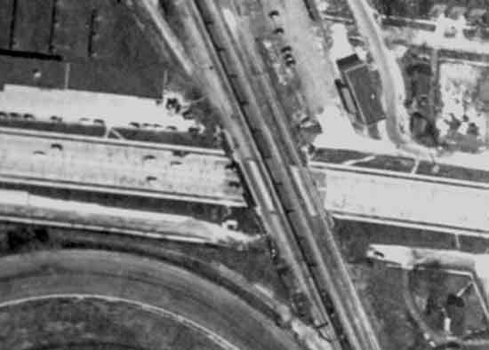 | ||
Psip Member Username: Psip Post Number: 1653 Registered: 04-2005 |
Here is an enhanced version of the original. Notice the rubble on the ground. This must have been a pavement lowering project. 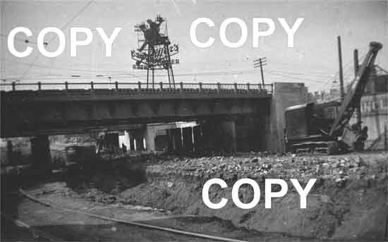 | ||
Bob_cosgrove Member Username: Bob_cosgrove Post Number: 477 Registered: 03-2005 |
I would have to guess it's the Woodward Avenue underpass just south of Milwaukee Avenue. Bob Cosgrove | ||
Mikem Member Username: Mikem Post Number: 3225 Registered: 10-2003 |
The Pfeiffer sign at Gratiot & Harper which Caldogven is thinking of:  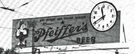 | ||
Caldogven Member Username: Caldogven Post Number: 24 Registered: 05-2006 |
Mikem You got it - the memory get kinda fuzzy as you get older! | ||
Psip Member Username: Psip Post Number: 1766 Registered: 04-2005 |
A Clue, A pix of a display window of the J.T. Sinclair Company, Detroit, Michigan Perhaps we can find out were this company had its store and yards. 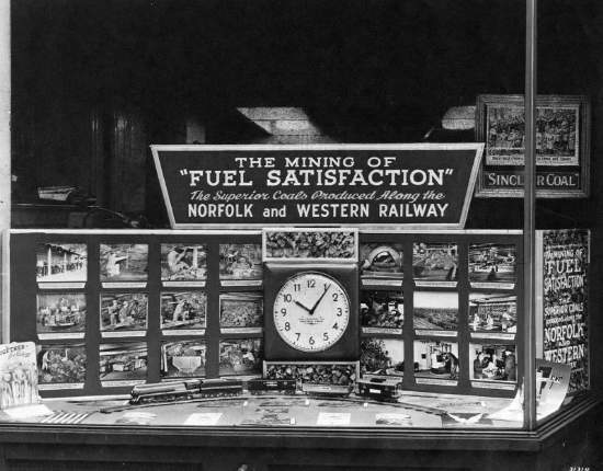 http://spec.lib.vt.edu/imagebase/norfolksouthern/F1/NS4492.JPG | ||
Psip Member Username: Psip Post Number: 1772 Registered: 04-2005 |
I think I got it! Grand River North of Warren. East Side of GR CUMA photos to follow. If there were was a JT Sinclair yard at that location, that will confirm it In the CUMA photo, you can see a shadow on the RR Tracks that looks like a man walking. Link to CUMA page. Caution HUGE PDF file. http://techtools.culma.wayne.e du/media/wayne/1949/ha-4-91.pd f | ||
Psip Member Username: Psip Post Number: 1773 Registered: 04-2005 |
Here are the pix 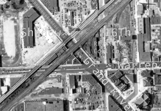 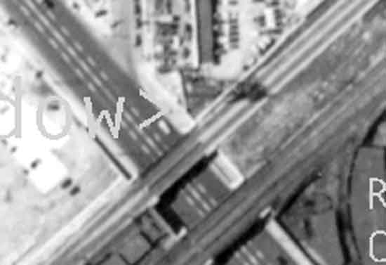 | ||
Livernoisyard Member Username: Livernoisyard Post Number: 2996 Registered: 10-2004 |
So how does the RR track at grade fit into that scenario? I cannot visualize that being the location. | ||
Psip Member Username: Psip Post Number: 1774 Registered: 04-2005 |
Here you go LY, from Wayne State Virtual Motor City Collection. Looking south, Notice the Trolley Tracks. The Sovay Co. on the right. Maybe they bought the yard from JT Sinclair 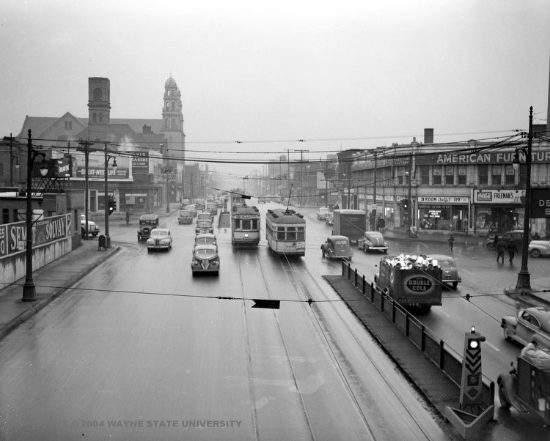 Looking North, Notice the cement work over the sidewalks and the support structure for the sign! 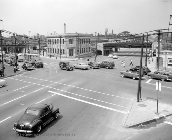 (Message edited by PSIP on April 11, 2007) | ||
Psip Member Username: Psip Post Number: 1775 Registered: 04-2005 |
Here is the intersection today 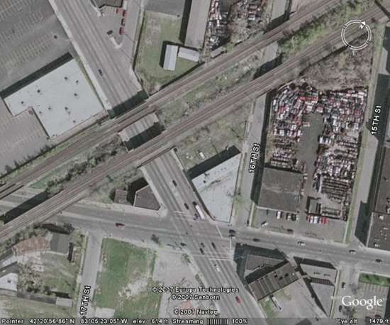 | ||
Livernoisyard Member Username: Livernoisyard Post Number: 2998 Registered: 10-2004 |
What is really needed is some kind of road construction log showing what work was done and when. Surely some records of this exist. If the track were one of two parallel trolley lines, why the grade differential? Was the (lowering) road work done first for the trolley so there would be less disruption of service? I assume that there would be another track. The track appears to curve toward the roadway, so it could have been some kind of temporary configuration. And maybe the trolleys shared a single track near this project??? | ||
Psip Member Username: Psip Post Number: 1776 Registered: 04-2005 |
Purely speculation, but I think they lowered the Southbound side first, then put in a temp trolley single trolley line, then did the Northbound side. Notice both trolley lines are on the NB side. OR, when this lowering project was done, it was a single line? This is pretty remote though. PSIP is proud of himself. (Message edited by PSIP on April 11, 2007) | ||
Livernoisyard Member Username: Livernoisyard Post Number: 3000 Registered: 10-2004 |
Well, we still need a record of that (and temporary trolley) roadwork being done in order to seal it. What agency would have the best accessible records on that? BTW, the overhead trolley wire is evident in the original picture. And it would be easy to effect an interlocking for a single-track trolley sharing by shutting off the electrical power to the trolley which is denied interlocking access. (Message edited by LivernoisYard on April 11, 2007) | ||
Psip Member Username: Psip Post Number: 1777 Registered: 04-2005 |
No idea LY, I have talked to the WCRC and they don't keep any records. (I think GR would be a county road.) Maybe the guy who wrote the Trolley book might know. (When Eastern Michigan Rode the Rails, By Jack E. Schramm, William H. Henning and Richard R. Andrews) The curved rail looks like a bypass for the mainline. I think a confirmation would be getting an address for Sinclair or Sovay would confirm the location via the INCL painted on the retaining wall. (Message edited by PSIP on April 11, 2007) | ||
Livernoisyard Member Username: Livernoisyard Post Number: 3001 Registered: 10-2004 |
There's also some blurred lettering on the "steam shovel" that might have some relevance. Grand River is the state highway going towards Lansing and eventually to Grand Rapids, although the city/county might have to foot the bill for its reconstruction. | ||
Psip Member Username: Psip Post Number: 1778 Registered: 04-2005 |
On the other hand, maybe there were 2 tracks, we can only see a part of the Southbound side. Road traffic must have been diverted to 16th Street going North and Loraine going South. It must have been an early form of Dodge the Lodge. | ||
Livernoisyard Member Username: Livernoisyard Post Number: 3002 Registered: 10-2004 |
What about the standards for the beer sign? Where exactly might they be? It's possible that something might still remain of it, considering how much of the past still lingers around Detroit. | ||
Mikem Member Username: Mikem Post Number: 3245 Registered: 10-2003 |
I've been on the road for a couple of weeks... J.T. Sinclair, Coal & Coke 5000 Grand River at W Warren 10525 Grand River near Oakman 1591 Wellington near Russell I suspected it was west side with the double overpasses (GR, 12th, 14th, Lawton, etc). | ||
Psip Member Username: Psip Post Number: 1784 Registered: 04-2005 |
BINGO MikeM Thank you. | ||
Ookpik Member Username: Ookpik Post Number: 180 Registered: 01-2007 |
Unbelievable! Thanks guys!  | ||
Queensfinest Member Username: Queensfinest Post Number: 86 Registered: 08-2006 |
Anyone know why the intersates in the Detroit area were built as depressed expressways as opposed to elevated? Seems like most other major cities went with elevated models. I know that either way, many neighborhoods were destroyed, but there's something about driving on the BQE, for example in NYC and viewing the skyline. Elevated Expressways also offer the chance for parks and parking under the structures. I suppose Detroit could cap their freeways and build parks above, something like Boston's Big Dig. but done right. It just seems really depressing though driving through Detroit and being below ground. At times you can't even tell youre surrounded by an urban area. At least if you were elevated you could have some scenery. Just to be clear, I'm not arguing for elevated over depressed expressways. I'm very familiar with the affects they all had on our cities. Just wondering why Detroit's are below-grade? |