Herrera Member Username: Herrera Post Number: 87 Registered: 11-2003 Posted From: 66.192.160.40 |
Looking at maps like I always do, I came across some real long city blocks. Between W. McNichols and Puritan are the long blocks of Turner, Tuller, Lilac, and San Juan. Why does Florence street not go all the way through? Anyone know the real anwswer? | ||
Focusonthed Member Username: Focusonthed Post Number: 319 Registered: 02-2006 Posted From: 24.192.25.47 |
I think a lot of Detroit (and other cities too) was built in pieces, like suburban subdivisions, except still mostly following the grid system. The only exception is when smaller streets are offset a few feet, or you have the large blocks. | ||
Gannon Member Username: Gannon Post Number: 6082 Registered: 12-2003 Posted From: 70.236.198.22 |
Often when the city grew, it occupied land with legacy structures or deeds that for whatever reason were never pursued with eminent domain, so no right-of-way to build a cross street to split the block in two. Same with the dead-ends...if a land-owner were sufficiently well-connected they could stop a thoroughfare, or keep it dirt. Sometimes parks were built with land donated to insure these other traffic restrictions happened. | ||
Mikeg Member Username: Mikeg Post Number: 91 Registered: 12-2005 Posted From: 69.136.155.244 |
Here's my two cents worth, based on the six years I spent approving subdivision plats as a city planning commissioner in one of those "evil" Metro Detroit suburbs. Looking at that area using Google Maps in the hybrid mode, it is clear to me that first subdivision to have been developed in that area encompassed the land bounded by McNichols on the north, the rear lot lines along the east side of San Juan, Puritan on the south and the rear lot lines along the west side of Woodingham. At that time, there apparently were no subdivision platting standards for unbroken street lengths and the subdivision plat was approved with the half-mile long blocks you see today. By the time the land to the east and west was later subdivided, the municipal planners had maximum street length standards and the result was east-west cross streets like Grove and Florence which stub into the rear lot lines of the older sub. However, since the existing sub had already been approved, the city did not have the authority to have the plat revised so that the cross streets could be pushed through. And since no developer is ever going to voluntarily give up two or more lots per street to add a cross street, you have the situation that persists even to this day. | ||
Herrera Member Username: Herrera Post Number: 88 Registered: 11-2003 Posted From: 66.192.160.40 |
Excellent responses. Thank you all very much. Mikeg, your job was probably very interesting. Good to be back, I havent been here in a long time. | ||
Rustic Member Username: Rustic Post Number: 2589 Registered: 10-2003 Posted From: 130.132.177.245 |
One thing I've wondered about those blocks were the alleys. Were there exits to/from the alleys along those looong blocks (there must have been) or were they just 1/2 mile long single lane alleys exiting onto puritan and the alley offa McNicholls. Google hybrid doesn't seem to show anything at least to me. Anyone KNOW the area? re the lack of cross streets, I'll bet that the land was originally part of Marygrove's campus and was developed piecemeal AFTER the street grid was laid out when Detroit was BOOMING with new housing construction. Someone prolly got some sorta special dispensation (eek!) to make a little more money adding a dozen more houses in that neighborhood than they should have. Yay Detroit! mikem often posts old city maps I'll bet they show something ... sending out the batsignal for mikem .... (Message edited by rustic on June 30, 2006) | ||
Danny Member Username: Danny Post Number: 4473 Registered: 02-2004 Posted From: 141.217.84.77 |
There are some more long city blocks in the East Side starting from E. Jefferson to the (Snobbyville) borders. 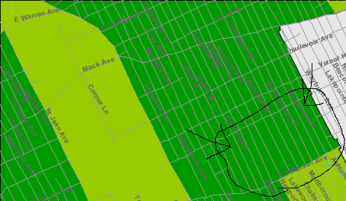 Those blocks are a 1/2 mile long. No street corners. | ||
Dougw Member Username: Dougw Post Number: 1207 Registered: 11-2003 Posted From: 136.1.1.101 |
Interesting thread. And thanks to Danny for pointing out those long blocks on the lower east side... I guess I never realized they were quite that long, I will have to check them out. (Although it looks like they are a teeny bit less than a 1/2 mile long.) I wonder if people prefer living on the long blocks. On the downside, that's a long drive down an alley if you live in the middle of the block, although I'd guess there are plenty of unofficial shortcuts across empty lots these days. On the upside, you have less cross traffic to deal with, and it's probably more secure. Overall I'd guess the positives outweigh the negatives. | ||
Eastsidedog Member Username: Eastsidedog Post Number: 598 Registered: 03-2006 Posted From: 12.47.224.8 |
Dougw, read a little Jane Jacobs. She will explain in exhaustive detail why long city blocks suck, particularly that they isolate parts of neighborhoods because pedestrians (and drivers) have fewer routes to get to points of interest, shopping, etc. With long city blocks people on one side of the block are a lot less likely to visit the other side of the block. | ||
Royce Member Username: Royce Post Number: 1675 Registered: 07-2004 Posted From: 75.9.244.48 |
Those blocks that Danny pointed out are mostly vacant. It's a bit scary to ride down them because it's like there's no end in sight, especially when all you see are boarded-up houses or empty lots. The street Philip is so bumpy between Kercheval and Jefferson that once you go down it you'll never do it again. At certain points between Kercheval and Jefferson you get these various lengths in the side streets. From E. Grand Blvd. to Iroquois you get the streets St. Paul, Agnes, and Lafayette between Kercheval and Jefferson. Between Cadillac Blvd. and St. Jean there are no between streets between Kercheval and Jefferson. Then essentially after Conner you get these long streets such as Lenox, Philip, and Ashland that have no cross streets between Kercheval and Jefferson. This Jane Jacobs that Eastsidedog pointed out may have a point about long streets. The longness of the ones mentioned above may have contributed to their emptiness. If you didn't live on the street, why would you want to travel by foot or car? You can't get to anything else quickly. Also, if people don't like to drive down streets because their too long, then how do you get people to notice your house when you want to sell it? Maybe people on these long blocks couldn't sell their homes because they got very little traffic. As a result they had to rent, and we know what usually happens in areas where most of the homes are rentals. BTW, those streets near Marygrove are so long because they aren't bisected by Grove and Florence like the other streets in that area. | ||
Naturalsister Member Username: Naturalsister Post Number: 746 Registered: 11-2004 Posted From: 68.30.12.136 |
My DPD brother was at a fire station in the area mentioned by Royce. I don't remember the street name, but it was a long bumpy mess. later - naturalsister | ||
Eastsidedog Member Username: Eastsidedog Post Number: 599 Registered: 03-2006 Posted From: 69.219.118.33 |
Royce, the lack of cross streets surely has contributed to their emptiness. Hopefully when the area is redeveloped (which is bound to happen eventually with the recent success of IV, WV and Islandview) they will add cross streets. Otherwise the neighborhood will continue to suffer from the same problems. | ||
Alexei289 Member Username: Alexei289 Post Number: 1188 Registered: 11-2004 Posted From: 68.61.183.223 |
the reasons those blocks are so long ans skinny is because of all the ribbon farmers from the 1700s and 1800s who owned everything from the river to mack ave. but only had land 150 feet wide. Thats where you get the names of the streets.. I.E. Riopelle, Dexter, Baldwin, Townsend, Seyburn. ect. all the last names of the farmers that owned the land. | ||
Livernoisyard Member Username: Livernoisyard Post Number: 1000 Registered: 10-2004 Posted From: 69.242.223.42 |
Those ribbon farms had no definite length. However, they sometimes clashed with other strips near where the rivers had a convexing bend. In addition, their widths were more typically 400 to 900 feet. (Message edited by LivernoisYard on July 02, 2006) | ||
Eastsidedog Member Username: Eastsidedog Post Number: 603 Registered: 03-2006 Posted From: 12.47.224.8 |
Alexei289, We're talking about the lack of cross streets (i.e. Lafayette, Agnes, St. Paul). This is what makes the blocks long and unwieldly. I have heard though that Agnes (Agnes St.) was Moses Field's (Field St.) daughter. | ||
Rustic Member Username: Rustic Post Number: 2610 Registered: 10-2003 Posted From: 128.36.14.165 |
that would be one looooooong ribbon farm to meander all the way past what is now UofD ...  | ||
220hendrie1910 Member Username: 220hendrie1910 Post Number: 29 Registered: 02-2006 Posted From: 20.137.2.50 |
Royce wrote:
On the topic of Philip St. between Kercheval and Jefferson, why is it that Manistique St. (one east) has a missing section in that block? Google Maps shows the street as continuous, but the air photo clearly shows a section not cut through (but with dirt tracks now across it). There appear to be alley outlets to Philip St. at the north and south edges of the property, suggesting that there may have been a monumental building on that site at one time. Puzzled in Ottawa. | ||
Mikeg Member Username: Mikeg Post Number: 112 Registered: 12-2005 Posted From: 69.136.155.244 |
Looking at the 1961 DTE aerial photo of that area from WSU/CULMA, it appears that it was a school site: 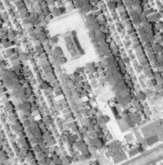 | ||
Mikem Member Username: Mikem Post Number: 2624 Registered: 10-2003 Posted From: 68.43.15.105 |
Rustic, I was too busy watching fireworks to see the bat signal. A little birdie delivered the message. I have no answers, just maps. 1918 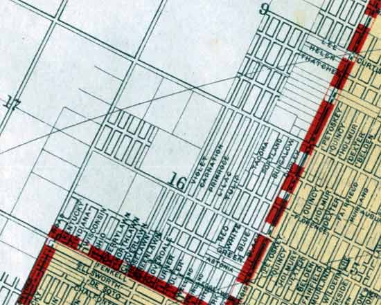 1923 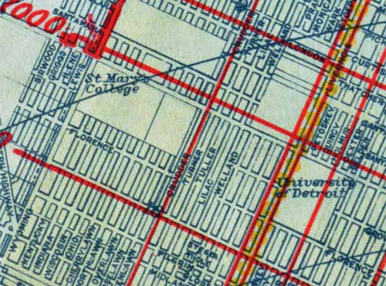 | ||
Mikem Member Username: Mikem Post Number: 2626 Registered: 10-2003 Posted From: 68.43.15.105 |
I realized this is the Fitgerald neighborhood, of which I have an intriguing book about its history. Here's a platt map centered on those streets from 1917, apparently an early subdivision. These streets seemd to have been renamed, some more than once, with Lilac the only one to retain its original "flower" name: 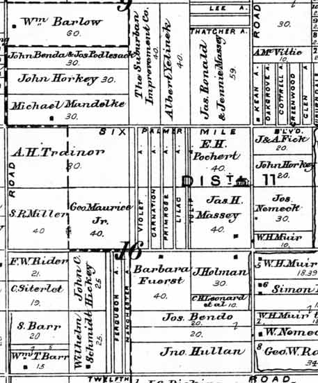 | ||
Mikem Member Username: Mikem Post Number: 2627 Registered: 10-2003 Posted From: 68.43.15.105 |
A social map of the area, 1900-1925: 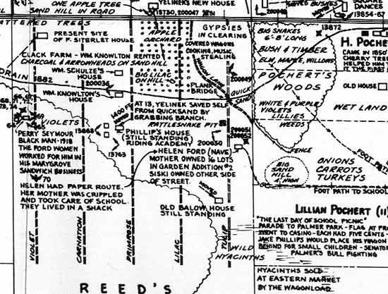 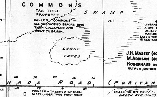 The "flower" streets extend halfway from Six Mile (a one lane trail) down to Puritan (Kanada Road). The scalloped line from the left outlines the eastern end of "Burrell's Woods"; according to the map, predominately maple and oak and a good area for hunting squirrels, rabbits, raccoons, and pigeons. Also home to big blue racer snakes. Tuller (Primrose) evidently had a quicksand bog which nearly took the life of old man Yelinek when he was a young man. | ||
Rustic Member Username: Rustic Post Number: 2633 Registered: 10-2003 Posted From: 128.36.14.165 |
for gods sake man more images of the "social map"! what the hell is that map? 6-8' snakes, quicksand, rattlesnake pits ... that sounds more like eastside than westside ... note: that there was apparently a black owned business in that part of town beofre it even became part of town. finally gypsy music in NW detroit? I thought ya had to go to Delray for that! | ||
Mikem Member Username: Mikem Post Number: 2628 Registered: 10-2003 Posted From: 68.43.15.105 |
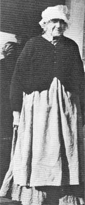
Near the top left corner of the map above is the "Present site of F. Siterlet house" on Violet (Woodingham). However a page in the book dedicated to its history places it at 16784 Turner (Carnation):
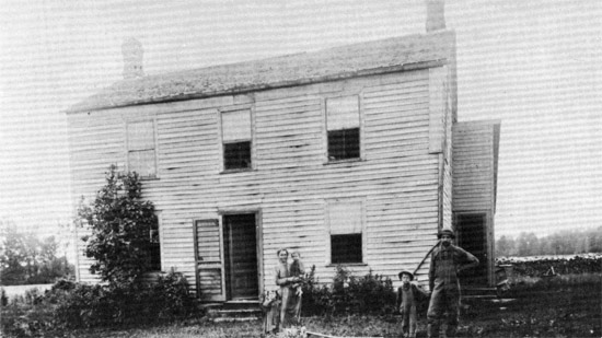 "The Siterlet house first stood near the corner of Snyder Road (Wyoming) and Kanada Road (Puritan). In this 1898 picture, the pile of cord wood, the garden in the front yard, the uncleaned woods in the background, and the lack of trees around the house despite their gift of shade, point to the continuing battle against the forest even at this late date. It was at the front door of this house that the Ojibwa band from Burrel's (Marygrove) Woods dropped deer meat in barter for corn. Frederick Siterlet stands next to his father." 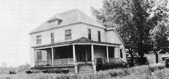 "The same house in 1918 with a new roof line, basement, porch, windows, and siding. The frontier look is completely gone, and two cars are visible in the barnyard." 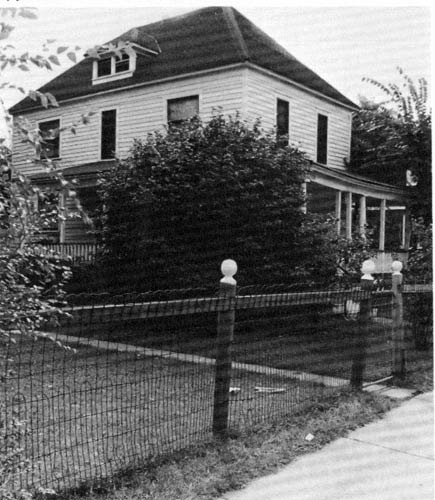 "The house was moved in 1922 to its present site, 16784 Turner, just south of McNichols." | ||
Mikem Member Username: Mikem Post Number: 2630 Registered: 10-2003 Posted From: 68.43.15.105 |
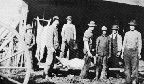
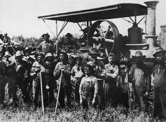 "Men stand with a power-driven machine, Humphrey Brown's thrasher, at Six Mile and Lilac in 1907. The machines took their price in flesh, too, including one of Brown's arms. How long in such a mechanical environment before one of the bright young men would invent an automobile?" | ||
Mikem Member Username: Mikem Post Number: 2631 Registered: 10-2003 Posted From: 68.43.15.105 |
I love neighborhood history:
| ||
Mikem Member Username: Mikem Post Number: 2633 Registered: 10-2003 Posted From: 68.43.15.105 |
To answer Herrera's original question, "All the forests were thinned by settlers whose lumbering activity peaked between 1850 and 1860, but some of the land was never completely cleared for farming. The strip of land running south from Post Junior High School to Fenkell was known as the Huckleberry Swamp. It was subdivided by Albert and Rudolph Longbegger in a land boom between 1892-1894. Lots were sold and, when the boom was over, the ownership was too confused to be returned to farming and it was pastured as Lonbegger's Commons. A similar strip of land from Puritan to McNichols just east of Greenlawn started as bad swampy farm land which was also subdivided in a premature land boom which clouded the titles and left it in a commons called Reed's. This last bit of irrationality led to the inconvienient half-mile-long streets from Greenlawn east to San Juan with no cross streets." | ||
Mikeg Member Username: Mikeg Post Number: 121 Registered: 12-2005 Posted From: 69.136.155.244 |
Mikem - Well done! Some mighty fascinating background info and photos, I might add. | ||
Danny Member Username: Danny Post Number: 4501 Registered: 02-2004 Posted From: 198.111.165.50 |
Most of those townships are in the Redford, Dearborn, Fordson and Greenfield TWP. area. Today annexed to Detroit and turned into middle income homes for white-folks and then black-folks moved in and turned into a ghettohood. | ||
Missnmich Member Username: Missnmich Post Number: 523 Registered: 11-2004 Posted From: 24.32.180.75 |
Great job! Now. Any information on those East Side blocks? | ||
Neilr Member Username: Neilr Post Number: 289 Registered: 06-2005 Posted From: 68.60.139.212 |
I believe that the longest uninterrupted block in Detroit is Fairway Drive between 6 and 7 Mile Roads. It's a straight mile shot with no cross streets at all. And only one open entrance, at 7 Mile. | ||
Rustic Member Username: Rustic Post Number: 2636 Registered: 10-2003 Posted From: 71.234.183.131 |
mikem comes through! ... so just for the record, Detroit realestate was a snakesnest with dubious title history etc even before Detroit was Detroit. Yay Detroit! | ||
Hornwrecker Member Username: Hornwrecker Post Number: 1291 Registered: 04-2005 Posted From: 12.64.24.205 |
This is from a 1916 map, showing the Eastside streets in question. Need an earlier map to see why nothing went through. 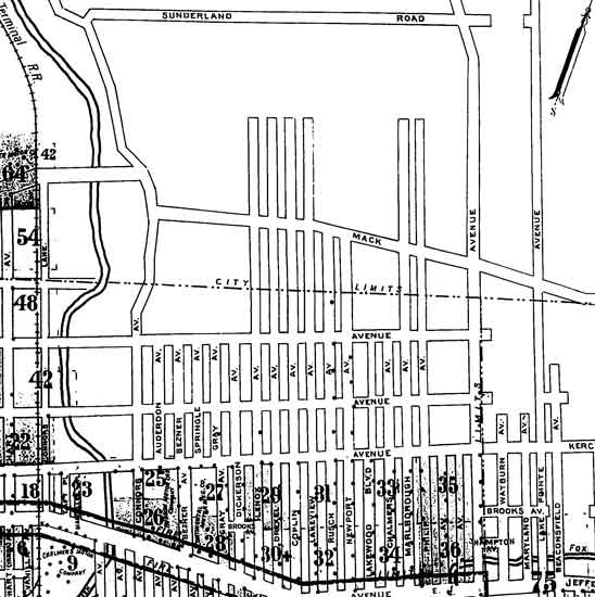 | ||
Dougw Member Username: Dougw Post Number: 1222 Registered: 11-2003 Posted From: 136.1.1.154 |
Eastsidedog -- Basically, you are right. Extremely long blocks are probably detrimental to a functioning urban environment... they make it harder to get to corner markets and that sort of thing. I was thinking more in terms of these particular long eastside blocks in their current state, which is not remotely urban. I drove up Philip St the other day, and it was pretty rough going as Royce says, very bumpy and also desolate, nearly empty of homes. Kind of had the feel of driving down a dirt road in the country. I was thinking that since these blocks are basically dead (for now) as urban areas anyway, it might be a perk that these long blocks provide some extra security through inaccessibility. But yeah, if this area gets redeveloped with some infill housing at some point, it might be nice to add in a cross street to make the blocks a bit more accessible. There is some urban potential in that area since those blocks are right next to Jefferson. | ||
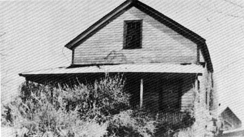
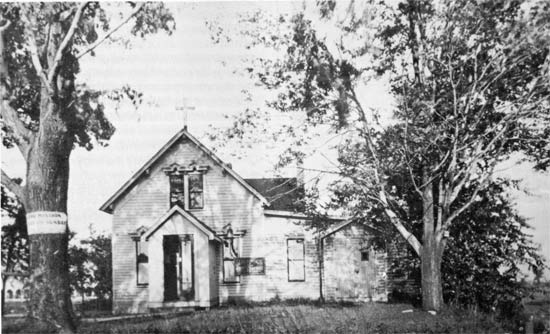
Mikem Member Username: Mikem Post Number: 2667 Registered: 10-2003 Posted From: 68.43.15.105 |
Drove by 16784 Turner today to see if the Siterlet house were still there: 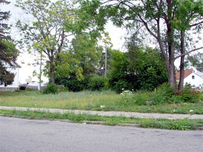 The only empty lot on the block. | ||
Mikem Member Username: Mikem Post Number: 2671 Registered: 10-2003 Posted From: 68.43.15.105 |
  | ||
Mikem Member Username: Mikem Post Number: 2672 Registered: 10-2003 Posted From: 68.43.15.105 |
Rustic asked about the alley situation: 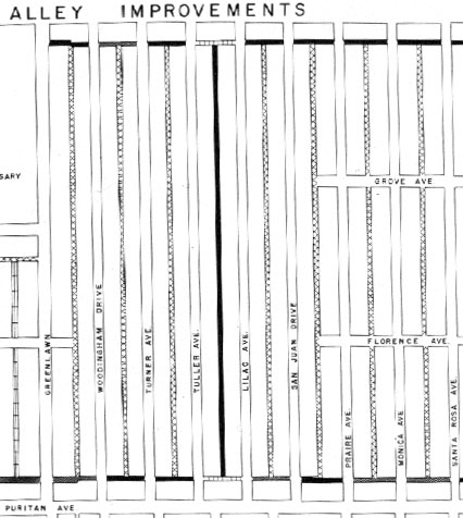  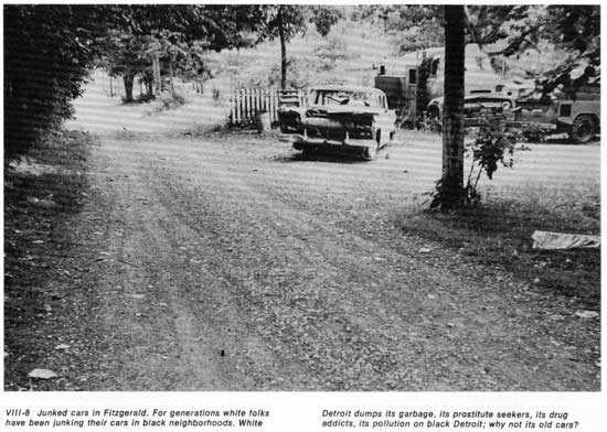 | ||
Mikem Member Username: Mikem Post Number: 2675 Registered: 10-2003 Posted From: 68.43.15.105 |
| ||
Mikem Member Username: Mikem Post Number: 2676 Registered: 10-2003 Posted From: 68.43.15.105 |
Did I tell the story of how Father McNichols bought the land for the current site of the University of Detroit?
| ||
Rustic Member Username: Rustic Post Number: 2685 Registered: 10-2003 Posted From: 128.36.14.165 |
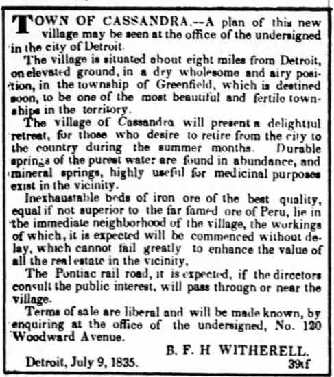
mikem ... terriffic stuff ... thanks! Real estate flim flams, abandoned cars, housing blight, crime, a decades old riot used allegorically ... and you knew who you were then,.................... Your posts re black people in Detroit in the antebellum north should remind forumers that blacks have had a significant presence in metro Detroit since its earliest days, not just from auto boom mississippi delta diaspora in the 20th century (and not just from the undergrond railroad either). I like the iron mines, mineral springs and cool clear water in the town of "Cassandra" ... if you compare that to the other map that seems to indicate snake pits (literally), sand pits, quicksand and woods full of criminals and vagrants ... it kinda puts some of the claims of today's developers in historical perspective. -- quick! where to I sign up for a BC condo or a Clinton twp townhome? lol -- .............................. ................ So, it seems that these long blocks are residue of a PRE-Detroit greenfield twp development that has since been overgrown by an auto boom detroit. The housing along these street were likely old (1800s) and generally blighted back when the modern Detroit subdivisions were being built and the lack of cross streets imo likely segregated those streets from the surrounding neighborhoods. I'll bet the housing was eventually torn down and replaced piecemeal and all that's left are these weird long blocks ... Yay Detroit! What a terrible wonderful place! (Message edited by rustic on July 13, 2006) | ||
Danny Member Username: Danny Post Number: 4550 Registered: 02-2004 Posted From: 141.217.173.162 |
Rustic, It took the power or SEGREGATION, XENOPHOBIA, DEMARCATION, THE GREAT JEWISH EXODUS AND WHITE FLIGHT to make Detroit ghettohoods black, blighted, crummy, dirty and improperly unclean and crime laden what it is today. YAY Detroit!! The great Black city. | ||
Royce Member Username: Royce Post Number: 1725 Registered: 07-2004 Posted From: 69.209.152.173 |
Just a thought about city blocks. In Woodbridge the blocks are very short as opposed to the streets like Philip along Jefferson, east of Conner and west of Alter. Could the shortness of Woodbridge blocks be one of the reasons for its success, good walkability and easy access by car? Now where my parents live and where I grew up we were sandwiched between Warren and Forest. On average each side of the street could house up to 25 houses. I believe that Woodbridge blocks contain less than half this number of houses on a given side of a block. There are only seven houses remaining on each side of my parents' block. Again, I wonder if the length of the block plays apart in its abandonment? I know that there are many factors that go into the success and failure of a neighborhood. Could having shorter blocks in many areas of Detroit have slowed or eliminated so much of the blight? BTW, I just got the bio of the late Jane Jacobs and can't wait to read her groundbreaking book "The Death and Life of Great American Cities." (Message edited by royce on July 25, 2006) | ||
Bvos Member Username: Bvos Post Number: 1735 Registered: 10-2003 Posted From: 134.215.223.211 |
Those long blocks on the eastside are supposed to be broken up into shorter blocks by the east/west streets as part of the Far Eastside Plan (if the FEP ever happens). The city planning department is aware of the problems it causes from a neighborhood viability standpoint. Once again, a big WOW and thanks to MikeM, MVP. Where do you get this stuff!? Is it just lying around your house? | ||
Eastsidedog Member Username: Eastsidedog Post Number: 678 Registered: 03-2006 Posted From: 12.47.224.8 |
Royce, "Death and Life" is great book. Unfortuantely she has few kind words for Detroit. Detroiters pretty much did every single thing that she said would destroy a city, freeways everywhere, lack of diversity of use, one way streets, lack of density (she says you need 100 units per acre to have a thriving successful city). It can be depressing when you realize how badly Detroit fucked up - and continues to fuck up. Although I must say there are many in Detroit fighting an uphill battle trying to implement some of her ideas, but it is such a grueling fight against the city and against the rest of ignorant suburban-minded society. Yeah, BTW she hates suburbs. | ||
Eastsidedog Member Username: Eastsidedog Post Number: 679 Registered: 03-2006 Posted From: 12.47.224.8 |
So there is hope Bvos. |