Planner_727 Member Username: Planner_727 Post Number: 33 Registered: 07-2006 Posted From: 69.87.150.106 |
Does anyone know the status of the former Uniroyal Site? Is the Bettis consortium still on board? What stage of approval are they at for plans? Also, does anyone have any pictures of the site pre-teardown? I have several images of the demolition of the main building on Jefferson, but photos of the main site have illuded me. Same with the grade-separated intersection at the Belle Isle Bridge. | ||
Andylinn Member Username: Andylinn Post Number: 212 Registered: 04-2006 Posted From: 64.141.144.2 |
this is during the demolition... but it's the best i could find... 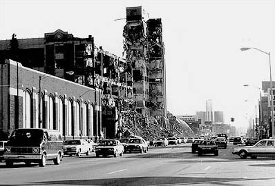 | ||
Swgz31 Member Username: Swgz31 Post Number: 8 Registered: 06-2006 Posted From: 35.11.203.8 |
Here's a couple from the Detroit News... 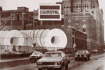 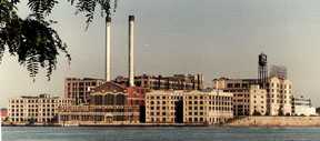 | ||
Lmichigan Member Username: Lmichigan Post Number: 4259 Registered: 10-2003 Posted From: 67.177.81.18 |
Imagine the skyline if they'd have been able to save the complex, and do to it what was doen to the Park Davis complex just to the west...what a site that would have been. I fear that this is going to be developed into another isloated "Harbortown" with a tower or two, surrounded by low-density townhomes. | ||
Detroit313 Member Username: Detroit313 Post Number: 181 Registered: 02-2006 Posted From: 12.45.2.184 |
Wow. You know looking at the old uniroyal that would have made a hellva loft project. 313 | ||
Detroit313 Member Username: Detroit313 Post Number: 182 Registered: 02-2006 Posted From: 12.45.2.184 |
lmichigan, I agree.313 | ||
Bibs Member Username: Bibs Post Number: 550 Registered: 10-2003 Posted From: 69.209.160.103 |
Wow! Thanks for the pics. They are waiting for the site to stop glowing before proceeding with development! I would try to search the archives. The Uniroyal site has been discussed in previous posts. I think that there was a ruling that the companies that contaminated the site would help clean it up. As you can imagine, soil contamination is a big issue and funding to clean the site is a big issue as well. | ||
Hornwrecker Member Username: Hornwrecker Post Number: 1506 Registered: 04-2005 Posted From: 66.2.148.15 |
There are photos of the Uniroyal/U.S. Rubber/Morgan & Wright tire factory on OCF pages 3, 10, and 11 located in the HOF, including a lot of original pics that Kathleen took during the demolition, if anyone doesn't want to do their own searches. There are old Morgan & Wright pics in the Library of Congress/Detroit Publishing Co archives. | ||
Livedog2 Member Username: Livedog2 Post Number: 1039 Registered: 03-2006 Posted From: 24.223.133.177 |
How's this? The Morgan & Wright Rubber Works! 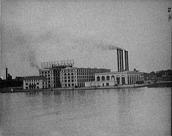 L of C Livedog2 | ||
Livedog2 Member Username: Livedog2 Post Number: 1040 Registered: 03-2006 Posted From: 24.223.133.177 |
Not to highjack this thread but Hornwrecker can you take a look at the thread called, "The Early Detroit Polish Community..." and see if you can shed any light on the question in the beginning about the "Anton Dlugi House." Thanks. Livedog2 | ||
Bvos Member Username: Bvos Post Number: 1899 Registered: 10-2003 Posted From: 134.215.223.211 |
While the structure itself would have made attractive lofts, the contamination on the site would not have. The process of making tires, at least back when the plant was in operation, involved using gasoline to separate the rubber from the molds among other highly toxic chemicals. The ground on this site is among the most contaminated in the Great Lakes. There is no possible way the site could have been cleaned up enough for residential use without razing the buildings. | ||
Iowaboy Member Username: Iowaboy Post Number: 16 Registered: 08-2006 Posted From: 63.91.26.158 |
Does anyone have information on the US Rubber Co plant that was located on E. Milwaukee Avenue in the 1948/9 era? Address? Years it was there? | ||
Gistok Member Username: Gistok Post Number: 2711 Registered: 08-2004 Posted From: 4.229.81.32 |
Bvos, it's kinda sad to see the great behemoths of the east side have all come down.... the massive Uniroyal complex, the huge Stroh's brewery, and the eastsides greatest monolith, the legendary "7 Sisters"... Practically the only massive complexes we have left are the former Parke Davis complex (River Place), and the orphaned "2 Brothers"! | ||
Mikem Member Username: Mikem Post Number: 2775 Registered: 10-2003 Posted From: 68.43.15.105 |
Iowaboy, I wouldn't think US Rubber would have two tire plants in such close proximity, but a check of a 1946 phone book shows them located at 3641 E Milwaukee. Sound familiar? Same address Hupp Motors had in 1940. Did US Rubber manufacture anything there or did they use it as an office or warehouse? | ||
Bibs Member Username: Bibs Post Number: 554 Registered: 10-2003 Posted From: 205.188.116.137 |
In trying to place this address using MapQuest.com,it becomes apparent that the address is on the grounds of the GM Cadillac plant. Lots of rail lines in the area. I would imagine that the rubber was brought in by rail to a warehouse. Just a guess. | ||
Detroitej72 Member Username: Detroitej72 Post Number: 156 Registered: 05-2006 Posted From: 66.184.3.44 |
quote: I think that there was a ruling that the companies that contaminated the site would help clean it up. As you can imagine, soil contamination is a big issue and funding to clean the site is a big issue as well. ______________________________ ___________________ That's correct, however the company, Uniroyal has sinced been bought out by a new firm and there is some legal questions as to just who is responsible for the clean up. More than likely, the city of Detroit will get hosed with the bill. Maybe they can qualify for some federal or state money to help offset the clean up costs. | ||
Iowaboy Member Username: Iowaboy Post Number: 17 Registered: 08-2006 Posted From: 63.91.26.158 |
I found a reference (a Sanborn map from 1949 I think) that shows the US Rubber Co in the old Hupp factory building, and the heading shows it as the US Rubber Co/Milwaukee Plant. This is the building in the 3500 block of Milwaukee Ave and west of the office/administrative building. What had been the Hupp office at 3641 Milwaukee Ave is still called the Hupp Corp but it is referred to a loft building, which according to a key I found means that it is a tenancy building occupied by various industrial entities. Could be US Rubber used the Hupp place as a warehouse and used some office space in the office building, or maybe they did some light manufacturing of some type. That could also explain why Ferguson used the address of 3639 E. Milwaukee Ave while US Rubber used the address of 3641 E. Milwaukee Ave. We know that Ferguson moved into the office building in mid 1947. Looks like Ferguson and US Rubber Co were joint tenants. Ferguson magazine advertising used 3639 E. Milwaukee Ave as an address beginning in 1947 and continuing into 1951. Beginning in late 1951 Ferguson began using Detroit 32, Michigan, as an address. I learned on this board that Detroit 32 is the Roosevelt Park Annex Post office which is next to Michigan Central Station. You people in Detroit have some fascinating history. I have never been to Detroit, but I am beginning to learn a few things. I searched the Old Car Factory archives on this site but could not find a reference to the US Rubber Co at the old Hupp place. Thought maybe I just did not know where to look. I had read that a steel company (was it Midland Steel) purchased the entire complex in 1950 but could find no other reference to US Rubber Co at this site. | ||
Iowaboy Member Username: Iowaboy Post Number: 18 Registered: 08-2006 Posted From: 63.91.26.158 |
I have been told that the Sanborn map I referred to in my earlier post is Vol 7, 1915-1949. I am not sure what the dates mean. Does that mean it reflects the way it was in 1949? I don't understand the date spread. Maybe some of you who are familiar with Sanborn maps can fill me in. | ||
Mikem Member Username: Mikem Post Number: 2783 Registered: 10-2003 Posted From: 68.43.15.105 |
Thanks Iowa, we need all the help we can get. I think the Sanborn date spread means that the volume was originally published in 1915 and revised in 1949. I have a copy of the original volume 7 (1915) but not the updated version. Do you have it in electronic form or paper? | ||
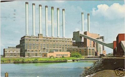
Gistok Member Username: Gistok Post Number: 2712 Registered: 08-2004 Posted From: 4.229.81.223 |
For those folks (west siders more than likely) who don't know who the "7 Sisters and 2 Brothers" were... they constituted the massive Detroit Edison Plant on the east side near St. Jean, south of Jefferson. They were so named (by eastsiders) by the number of smoke stacks they had. There was a group of 7 lower stacks in the main power plant building, and 2 taller stacks in the slightly taller annex building. The enormous power plant that was the 7 sisters portion was torn down about 20 years or so ago. That leaves the large annex building and the 2 massive smoke stacks ("2 Brothers") you see on the lower east side near Jefferson. Now it's only a fraction of its' former self. Another monolith that was torn down on the east side looked more like a monstrosity... old Dodge Main. It was a huge, almost scary looking plant with enormous pipes coming out the side of the main bulk of the building. They looked almost as though they were some alien sort of organic growth coming out of the sides of the building. It would have made a great backdrop for one of the Alien horror flicks. Hornwrecker, got any cool pics of either the Dodge Main plant or the 7 Sisters/2 Brothers? | ||
Hornwrecker Member Username: Hornwrecker Post Number: 1520 Registered: 04-2005 Posted From: 66.2.148.144 |
I've got a link to over 300 photos of an empty Dodge Main, and original plans at the Library of Congress. I can't post a direct link, because search results seem to be time sensitive, so you'll have to search for "dodge main" or if you're ambitious with a lot of time to kill, do a search for Poletown. LOC/Built in America, Historic Buildings Survey Sorry, I haven't spent time looking for the Seven Sisters in photos or maps yet. Perhaps in the future, when the other three major online history projects die on this site. Right now we're still doing the OCF, DFD, and Car Dealers, + a few small ones. As an aside, if I can don my moderator hat, please put your photo on another line, and not immediately after a sentence. Hit enter a few times before you upload, to spare some users scrolling across (in their crappy browsers). (Message edited by Hornwrecker on August 28, 2006) | ||
Livedog2 Member Username: Livedog2 Post Number: 1047 Registered: 03-2006 Posted From: 24.223.133.177 |
Gistok, you can't even imagine how literally scary the Dodge Main Plant was in the waning years of its existence. I did some work there on a consulting basis and you couldn't even go to the bathroom alone for fear of being mugged and rolled. It reminded me of the lawlessness that existed during the Vietnam War. In Nam there wasn't much trouble in line infantry units in the early and middle part of the war. Of course it got really bad, even in the Marine Corps, in the later parts of the war. But, during the middle and late parts of the war after I left Nam and was in Guam and Okinawa it was brutal. The race thing was really heavy in the air and we had to travel in packs just to defend ourselves going from the EM Club to the barracks. Sorry for the rant but your comment just brought that up. I get so sick and tired of the laws and the legal system but then I remember those times and thank G-d for law and order because if we didn't have it it would be chaos. Livedog2 | ||
Mikem Member Username: Mikem Post Number: 2784 Registered: 10-2003 Posted From: 68.43.15.105 |
 | ||
Livedog2 Member Username: Livedog2 Post Number: 1049 Registered: 03-2006 Posted From: 24.223.133.177 |
Mikem, how the heeeell do you get the photos you post to look so good? That's probably rhetorical as much as lieral. I re-size, play with, downsize, crop and all kinds of crap and then my photos still don't look worth a schitt when I post them. Livedog2 | ||
Mikem Member Username: Mikem Post Number: 2785 Registered: 10-2003 Posted From: 68.43.15.105 |
I dunno...that last one is a postcard from the '60s. I have one but I'm too lazy to scan it so I found this one on eBay. | ||
Iowaboy Member Username: Iowaboy Post Number: 19 Registered: 08-2006 Posted From: 63.91.26.158 |
Thanks Mikem. I have it in electronic form but I have only the one page that shows the Hupp buildings (including the one labeled as US Rubber Co, and then about the four square block area to the south. So the map goes as far south as Trombly Ave, Moran on the west, and Mt. Elliott on the east. To the north it shows the entire Hupp complex (factory and office building). So if this map reflects 1949, that demonstrates that Ferguson and US Rubber Co shared space in the building. US Rubber Co moved in before Ferguson and used the address of 3641, so the postman had to come up with an address for Ferguson. | ||
Burnsie Member Username: Burnsie Post Number: 593 Registered: 11-2003 Posted From: 35.12.19.227 |
The Seven Sisters and their plant were not demolished 20 years ago, but in the summer of '96. | ||
Hornwrecker Member Username: Hornwrecker Post Number: 1521 Registered: 04-2005 Posted From: 66.2.148.144 |
Iowaboy, addresses were kind of arbitrary then, only dealing with the extent of how far the lot went for these large buildings. The old Hupp factory probably had a range of a few hundred in the 6000 numbers in which to choose a mailing address, bearing no relationship to reality of where it was in the factory. Nowadays, the mailing address would be to where the main entrance is in relationship to the lot number, and others located in the same building would use box/room numbers or something similar for an address. I've run into many examples from the 1910-30s where the same building and company have a different address on each ad or piece of stationary for that time period. Guess what, they're all correct. This is one of those details that was highly variable, and at the whim of the addressee. | ||
Pdtpuck Member Username: Pdtpuck Post Number: 193 Registered: 01-2006 Posted From: 208.251.168.194 |
Hornwrecker- I have a link in "My Favorites" on my computer here at work for the Dodge Main @ the HABS/HAER (for the uninitiated, it stands for "Historic American Buildings Survey/Historic American Engineering Record) LOC site that's been there since June 6, 2006 ...is this different than the link you talked of above? It's been there going on three months and still works (or I may be talking of something completely different!). Dodge Main @ HABS/HAER (Message edited by pdtpuck on August 29, 2006) | ||
Iowaboy Member Username: Iowaboy Post Number: 20 Registered: 08-2006 Posted From: 63.91.26.158 |
Thanks Hornwrecker. Mikem, does the 1946 phone book (if you have the yellow pages) show a listing for a restaurant in the Hupp building (3600 block of East Milwaukee)? The map has a notation that the 1st floor has a "REST" I assume that means a restaurant. On some buildings across the street they use the abbreviation "Restrt" which I also assume means restaurant. I can't find the abbreviations on the key. They show a toilet somewhere else, so apparently REST does not mean restroom?? | ||
Sven1977 Member Username: Sven1977 Post Number: 198 Registered: 04-2004 Posted From: 209.220.229.254 |
Lowaboy, as Mikem said about the Sanborn Maps, the first date was when it was originally published and the last date is when it was last revised. There could be any number of revisions in the middle. The books are about 24" by 24". When a map was revised, the publisher would paste the revision over top of the existing map. Over the years, whe whites of the paper changed and the glue contracted making the revised books ugly and wavy. I can't tell you how many times I checked out a book to investigate an address in 1918 only to find the "proposed (Lodge) Freeway" glued on top. The recent Sanborn maps you have seen on this website have been coming from electronic files which may have been made from master maps or from well photographed revised maps. | ||
Mikem Member Username: Mikem Post Number: 2786 Registered: 10-2003 Posted From: 68.43.15.105 |
Iowaboy, doing a quick scan of the 10 pages of restaurant listings (and by quick I mean like 20 minutes) the only one I could find near there was the Goodyear Bar at 3672 E Milwaukee. Possibly the one across the street? | ||
Iowaboy Member Username: Iowaboy Post Number: 21 Registered: 08-2006 Posted From: 63.91.26.158 |
3672 E Milwaukee looks like it is one of those two story commercial buildings that sits on a 50-foot wide lot which is a good sized lot for that neighborhood. The building is divided lengthwise so there are two portions to the building. Each side has separate addresses. Each portion is marked with an "S" which I think means "store" so it looks like the Goodyear Bar would be a good fit. | ||
Aiw Member Username: Aiw Post Number: 5796 Registered: 10-2003 Posted From: 24.57.57.12 |
Iowaboy, the big "S" on a building in the Sandborn maps denotes the building was equiped with sprinklers. | ||
Iowaboy Member Username: Iowaboy Post Number: 22 Registered: 08-2006 Posted From: 63.91.26.158 |
Interesting. But I found two different legends on the internet, both say that S = Store. For automatic sprinklers the keys use the letters "AS" enclosed in a circle. One of these is titled "Sanborn Map Legend," the other says "Digital Sanborn map Key." | ||
Hornwrecker Member Username: Hornwrecker Post Number: 1524 Registered: 04-2005 Posted From: 66.2.148.108 |
I agree, Iowaboy. Looks like Aiw is making stuff up again. | ||
Iowaboy Member Username: Iowaboy Post Number: 23 Registered: 08-2006 Posted From: 63.91.26.158 |
On my Sanborn map of the old Hupp main factory building shown being used by US Rubber Co, I notice a notation that reads like this "AUTO TIRE W HO ALL FLS" I guess that means warehouse???? | ||
Mikem Member Username: Mikem Post Number: 2798 Registered: 10-2003 Posted From: 68.43.15.105 |
AUTO TIRE W HO ALL FLS = Auto Tire Warehouse All Floors | ||
Deputy_mayor_2026 Member Username: Deputy_mayor_2026 Post Number: 115 Registered: 04-2006 Posted From: 141.211.222.28 |
My grandfather worked at the Uniroyal plant for many, many years | ||
Digitaldom Member Username: Digitaldom Post Number: 518 Registered: 08-2004 Posted From: 24.192.148.150 |
My dad worked at Conners Creek for several years.. Yeah they took down what they called the "low" side a few years ago.. The plant still operates the "high" side.. I believe it's now natural gas But I would have to ask my dad. The low side just wasn't ecomonical.. The turbines and generating equipment was VERY old and produced very little power.. | ||
Digitaldom Member Username: Digitaldom Post Number: 519 Registered: 08-2004 Posted From: 24.192.148.150 |
Ohh forgot to define what low-side and high-side really mean... It has NOTHING to do with how high the building is... Low-side means Low pressure steam versus high pressure steam.. High pressure spins faster and creates more energy and the units are smaller.. Low pressure on the other hand has one advantage.. Lower operating costs.. Lower pressure means the stress is lower... Thought you would want to know... |