Mikem Member Username: Mikem Post Number: 2808 Registered: 10-2003 Posted From: 68.43.15.105 |
Following up on the "Long City Blocks" thread now in the archives, I see a few were asking about long eastside blocks. I came across this tonight on a 1921 map I have. Between Mack and Harper, between Balfour and Buckingham was a long, unbroken stretch of land. Looking closer I noticed it had something hiding among the street names: 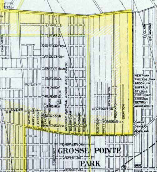 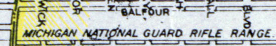 I can't tell if even E Warren cut through the lot at the time. Yellow depicts the city limits (Alter, Mack, Cadieux, Harper). Two streets were later squeezed into the lot: Chatsworth & Berkshire. | ||
Rustic Member Username: Rustic Post Number: 2779 Registered: 10-2003 Posted From: 71.234.183.131 |
One hopes they adjusted for windage ... | ||
Gistok Member Username: Gistok Post Number: 2743 Registered: 08-2004 Posted From: 4.229.72.241 |
Very interesting map. This looks like the early development of East English Village. The eastern border road is Cadieux Rd. Only some of the East English Village streets existed in 1921... Going west from Cadieux Rd. should be Harvard (missing), Grayton (shown), Bishop (missing), Yorkshire (was it Poupard back then?) and Kensington (shown). Then comes Whittier... today that stretch is a boulevard known as E. Outer Drive. Then comes Audobon, and Courville (missing), and the long unnamed yellow line street (going into Grosse Pte. Park) is 3 Mile Dr. Also, the east/west street near the top of the map known as "Leipzig" no longer exists... today it is a boulevard known as Chandler Park Dr. (and parts of it double as E. Outer Drive). Ya gotta love the street names in this area... famous British, German and American cities. | ||
Mikem Member Username: Mikem Post Number: 2809 Registered: 10-2003 Posted From: 68.43.15.105 |
I'm not sure of the exact date of this map. It came from an atlas published in 1921, but the map itself may not have been updated for several years prior. I have a 1918 map (uncertain of that date as well) which shows more development than this one. Gistok, the long road highlighted in yellow (actually a pale green) is the planned route of the new "Outer Boulevard", now known as Outer Drive. The map maker colored playgrounds, parks, and parkways in a light green color. You can see that it follows Leipzig to Alter where it splits and runs north beyond Harper (Outer Dr) and continues west off the edge, running into Chandler Park (Chandler Park Dr). Also note the cluster of streets on the east side of Cadieux all named after cities, only a few of which have kept their original names. (Message edited by MikeM on September 02, 2006) | ||
Dtown1 Member Username: Dtown1 Post Number: 76 Registered: 08-2006 Posted From: 68.74.28.185 |
Doesnt look like it did, MikeM. Just the name probably overran the end of the road........ 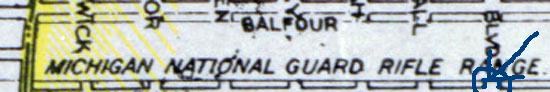 . If it did, then the streets went under the range. . If it did, then the streets went under the range. (Message edited by Dtown1 on September 02, 2006) | ||
Gistok Member Username: Gistok Post Number: 2745 Registered: 08-2004 Posted From: 4.229.72.53 |
That's interesting about the "planned route" of Outer Drive Mikem! However they did have a change of plans when it came to the last stretch of Outer Drive. Outer Drive follows Chandler Park Drive eastward, and takes an abrupt south where Whittier (and not 3 Mile Rd.) is. It continues south until Mack where E. Outer Drive ends. Continuing south in its' place thru Grosse Pointe Park is Whittier Rd. For anyone who lives in East English Village will tell ya... Audobon is 1 block WEST of that final stretch of E. Outer Drive. | ||
Nedab3 Member Username: Nedab3 Post Number: 95 Registered: 01-2004 Posted From: 216.96.58.127 |
If I read the map right e. Warren and Balfour is where Peace Lutheran Church is and was in the 40's when I moved to Detroit. My dad taught there from 1944 till 1961. | ||
Dtown1 Member Username: Dtown1 Post Number: 80 Registered: 08-2006 Posted From: 68.255.163.182 |
Well ned, this is a photo from 1921, and the Peace Lutheran Church probably wasn't built til after 1925. |