Tarkus Member Username: Tarkus Post Number: 228 Registered: 04-2006 |
I'm hoping someone here knows the origin of Balduck Hill. I was always told it was an old garbage dump. Does anyone know the true answer? | ||
Tarkus Member Username: Tarkus Post Number: 229 Registered: 04-2006 |
Well I found Balduck was named after Remi Balduck born 1918 in Detroit. He was awarded the Navy Cross after being killed on Guadalcanal in 1942. This ship the USS Balduck was named after him in 1944. Could not find anything on origins of the hill.  | ||
Flybydon Member Username: Flybydon Post Number: 76 Registered: 01-2005 |
If memory serves flyby correctly, was told by his grandfather (who lived across the street from Balduck) that the dirt to form the play hill was what was left over from the building of the boulevards on Chandler Park and Outer Drive. Unable to confirm. | ||
Charlottepaul Member Username: Charlottepaul Post Number: 347 Registered: 10-2006 |
I haven't ever heard of this hill. Could someone fill me/us in on possibly the location of it? | ||
Harsensis Member Username: Harsensis Post Number: 146 Registered: 07-2005 |
Balduck Park is in the east side near St Johns Hospital on Chandler Park Drive. I would have to go along with left over dirt from road work Don. That seems the the most likely reason. (Message edited by harsensis on January 28, 2007) | ||
Citylover Member Username: Citylover Post Number: 2078 Registered: 07-2004 |
There was a brutal murder of a black woman at Balduck back in the late 80's. I remember it was white supremacists i.e. skinheads that were convicted of the murder.I also remember that it was not a prominent story in the news at the time.It is cynical but the evidence at least at that time was who cares about some black whore crackhead. | ||
Scs100 Member Username: Scs100 Post Number: 371 Registered: 12-2006 |
Best sledding hill on the far east side. I have many good memories of that place (including hitting a few trees). | ||
Ohudson Member Username: Ohudson Post Number: 178 Registered: 09-2004 |
I used to ride my bike down the back of the hill. I went to Marquette Elementary/Middle School (which is located down the street on Canyon)for 2nd thru 8th grades. The back of the hill is pretty rugged and has trees. At the bottom of the hill (if you keep control of the bike) you have the fences on the homes right behind the hill to try to avoid crashing into. Great times.... | ||
Michmeister Member Username: Michmeister Post Number: 70 Registered: 10-2006 |
Kite flying in the summer with my family. Nice park. | ||
Kathleen Member Username: Kathleen Post Number: 1887 Registered: 10-2003 |
Balduck Park was the site of many good times!! I remember the playground, the skating pond and the warming house, sledding on the hill, tobogganing on the toboggan run, St. Clare CYO football games, Parks and Rec softball and baseball games, the tennis courts, and the Nature Preserve on the north side across Chandler Park Dr. I also remember the archery range (not sure if this was open to the public, or run by a club). | ||
Gistok Member Username: Gistok Post Number: 3516 Registered: 08-2004 |
The back side of Balduck Park hill was where as a kid we used to play hide and seek among the huge boulders and bushes. I remember as a kid there used to be a driveway going from Chandler Park Dr. entranceway back behind the hill to the warming house. That driveway was removed decades ago, along with the toboggan ramps. | ||
Imperfectly Member Username: Imperfectly Post Number: 178 Registered: 06-2004 |
Sledding at Balduck was a must for eastside kids...hey remember the rickety stairs of death that ran up the hill ???? It was safer to just walk back up the hill thru oncoming sled traffic. Gosh I miss being a kid ! We also played all of our CYO games there too. | ||
Harsensis Member Username: Harsensis Post Number: 150 Registered: 07-2005 |
You still have to be careful on those steps and then the top after you get off the steps is all ice, very slippery. So it is still safer to walk back up the hill. | ||
Detroiterinspirit Member Username: Detroiterinspirit Post Number: 28 Registered: 01-2005 |
The archery range was still functioning in the early 80's and open to the public. My friend, Joe, and I stopped using the range in high school as it became clear the city was not maintaining the range. The hay back-stop were old and our arrows went right through them...even as stupid high school kids, we felt it was too risky. Sledding down the hill with a bunch of friend from Notre Dame and Regina with bottles of peppermint schnapps buried at the bottom of the hill and at the top of the hills....nothing better. | ||
The_rock Member Username: The_rock Post Number: 1520 Registered: 11-2003 |
We played softball in the old Detroit Recreational League Wed. night games at Balduck. Our law firm entered a team for about 10 years, and we only made the play-offs one time, always getting beat by svelt, hard-hitting youngsters from other non-attorney teams. Some had m.j.- induced sluggers. We were sponsored by Irvinck's Bar ( E. Warren just West of Cadieux),then Shield's Pizza ( The Original one at the corner of Shields ) and later on, when the Onyx Bar( also on E. Warren) said "no", we had to turn to a Wisconsin Transit Company , owned by the father of our short stop. So he got to start all those games. Surprisingly, a lot of the local neighborhood brought out their chairs and watched those games. | ||
Crash_nyc Member Username: Crash_nyc Post Number: 746 Registered: 08-2004 |
I can't offer much in the way of the history of Balduck Park's hill, just great memories. My sisters and I used to toboggan down that hill every winter. We loved the 'speed track' -- the one that got iced-over. Fast runs! In the summer we'd go to Balduck Park to fly kites and launch rockets. Definitely an "East Side" thing. | ||
Bigjeff Member Username: Bigjeff Post Number: 37 Registered: 08-2006 |
A friend of mine lived on Radnor street. It was the first block south of Balduck Park. I remember when we grabbed a pair of snow ski's and an old couch out of the garbage and would ride the couch down the hill. Four or five people would pile on the couch like there was a good program on t.v. and pour the glasses full of peppermint schnapps and hot chocolate. Oh the good times!!! | ||
Imperfectly Member Username: Imperfectly Post Number: 180 Registered: 06-2004 |
Bigjeff- thats hilarious ! | ||
Craggy Member Username: Craggy Post Number: 223 Registered: 10-2003 |
I took my son there several times last year. The sledding is still great, with great people hanging out having fun. | ||
Rrl Member Username: Rrl Post Number: 724 Registered: 12-2003 |
Its quite likely that the Balduck hill was built from the excavation spoils of the highway construction of I-94. Vernier Hill in GPShores, which is a similar type of knoll, is exactly that, built from excess soil excavated from the highway. | ||
Gistok Member Username: Gistok Post Number: 3528 Registered: 08-2004 |
Balduck Park hill predates I-94. My earliest recollections of it were from 1960, when my family moved to Marseilles (4 streets from the park). I-94 was built as far as Vernier at that time. But I do remember that trees and shrubbery were already well developed on the back side of the hill. Flybydon's explanation of the hill being built from leftover materials of neighboring Chandler Park Dr. seems more plausible. That would probably have been in the 1940's (my parents house was built in 1946). | ||
Quozl Member Username: Quozl Post Number: 148 Registered: 07-2005 |
The 1949 DTE aerial photograph of the park reflects recent fill of the hill and new home construction on Farmbrook and Lodewyck Streets between Chester and Linville. http://txqa.com/img/balduckpar k.jpg | ||
Taj920 Member Username: Taj920 Post Number: 174 Registered: 01-2004 |
Good old Austin Catholic Prep across Warren was yet to be built in this shot. | ||
Quozl Member Username: Quozl Post Number: 149 Registered: 07-2005 |
The 1952 aerial photograph shows the hill has stairs and toboggan run is complete, ball fields in and Austin Catholic Prep is under construction. http://txqa.com/img/bp52.jpg | ||
Mikem Member Username: Mikem Post Number: 2980 Registered: 10-2003 |
There is a 10 million gallon underground water reservoir at the corner of Warren and Canyon. I don't know how much dirt that equates to nor where it went, but I don't think it was built until the 1950s. Ford Expressway ended at Mt Elliott until 1958 and Conner (Norcross) until 1959, and the hill was already there by 1949. Chandler Park Drive looks new in those 1949 aerials, so I bet FlybyDon is right. | ||
Quozl Member Username: Quozl Post Number: 152 Registered: 07-2005 |
1,336,805.56 cubic feet. 1 US gallon = 0.133680556 cubic feet | ||
Mikem Member Username: Mikem Post Number: 2981 Registered: 10-2003 |
The grounds of Austin were formerly a city dump/recycling yard for the village of Grosse Pointe. Maybe that's where the idea came from that Balduck/Canyon Park was a city dump. Was Austin demolished, or did St John remodel the old building? | ||
Mikem Member Username: Mikem Post Number: 2982 Registered: 10-2003 |
So how many cubic feet in that hill? | ||
Quozl Member Username: Quozl Post Number: 153 Registered: 07-2005 |
Is the hill about 20 feet tall Mikem? | ||
Scs100 Member Username: Scs100 Post Number: 381 Registered: 12-2006 |
The stairs are still there. From what I can tell that is. | ||
Jimaz Member Username: Jimaz Post Number: 1445 Registered: 12-2005 |
quote:Does anyone know of a way to estimate such a thing without resorting to calculus? Surely landscapers must have a way to make such estimates. | ||
Mikem Member Username: Mikem Post Number: 2983 Registered: 10-2003 |
20' at least, although the hill looks smaller every year. Haven't been to the top in a long time. | ||
Quozl Member Username: Quozl Post Number: 154 Registered: 07-2005 |
I do, that is why I was curious as to the height. Mikem, the location of the underground reservoir is the rectangle east of this building, correct? http://www.google.com/maps?q=D etroit,+MI&ie=UTF8&z=18&ll=42. 412285,-82.917042&spn=0.001695 ,0.005407&t=k&om=1 (Message edited by quozl on January 29, 2007) (Message edited by quozl on January 29, 2007) | ||
Craggy Member Username: Craggy Post Number: 225 Registered: 10-2003 |
I remember one day last year, snowmobile tracks were all over the place in the park. I'm sure the residents loved that. | ||
Mikem Member Username: Mikem Post Number: 2985 Registered: 10-2003 |
Yes, that's it. Not sure if it is under the entire fenced area, or just on the north side of the building: 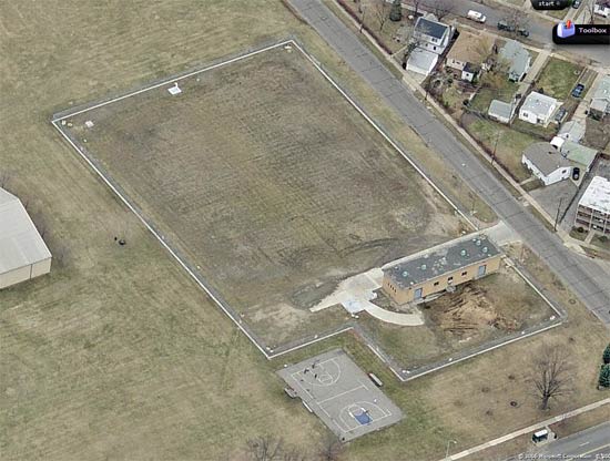 | ||
Gistok Member Username: Gistok Post Number: 3529 Registered: 08-2004 |
Most of Austin was demolished for the St. John/Bons Secours nursing home that is there right now. I do believe that the chapel was not demolished but reused in some capacity. | ||
Quozl Member Username: Quozl Post Number: 156 Registered: 07-2005 |
Thanks Mikem. That is what I suspected by reviewing the old DTE pics from 52, 58 and 61. | ||
Jimaz Member Username: Jimaz Post Number: 1447 Registered: 12-2005 |
Quozl, could you share your formula for estimating the volume of a hill from its height? Or is it from a table? Thanks! | ||
Quozl Member Username: Quozl Post Number: 157 Registered: 07-2005 |
L x W x H Jimaz, though for the hill one takes in consideration the slope of all sides. This is a good primer for you: http://aquanic.org/publicat/us da_rac/efs/srac/103fs.pdf | ||
Mikem Member Username: Mikem Post Number: 2988 Registered: 10-2003 |
You're not using the volume of a cone? | ||
Quozl Member Username: Quozl Post Number: 159 Registered: 07-2005 |
Yes, kinda sorta. Right now I am trying to get a rough guestimate of the length of the hill on all sides to determine a radius. | ||
Mikeg Member Username: Mikeg Post Number: 514 Registered: 12-2005 |
From the topo map below, I estimate that the hill is about 20 feet high and about 300 feet in diameter at its base and about 150 feet in diameter at its truncated (flat) top. Using the formula for the volume of a cone with a radius of 150 ft. and a height of 40 ft., less a cone with a radius of 75 ft and a height of 20 ft., I get 824,668 cubic feet. Formula for the volume of a cone: V=(1/3)*3.14159*(R*R)*(H)  | ||
Harsensis Member Username: Harsensis Post Number: 152 Registered: 07-2005 |
I remember snowmobiling these in the late 70's. One of my friends dad took us all for rides across Chandler Park Drive from the hill. | ||
Quozl Member Username: Quozl Post Number: 160 Registered: 07-2005 |
Good work Mikeg. Still leaves roughly 500,000 cubic feet of dirt remaining. | ||
Mikem Member Username: Mikem Post Number: 2990 Registered: 10-2003 |
Well, this thread has gone to the nerds. The 1.3 Mcf of dirt doesn't include the extra amount dug out for foundations, walls, pipes, pump chambers, etc. I don't think the hill is as flat topped as you think, so it could be even smaller in volume. 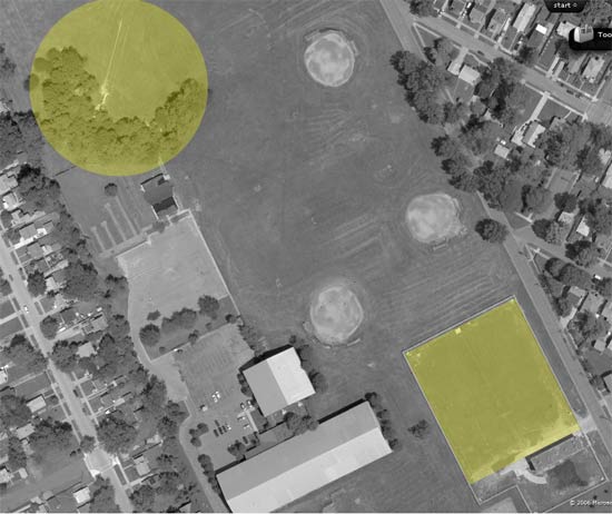 Th pumping building was there in the 1956 aerial but not in 1952 or 1949, even though the hill was, so it probably isn't from the excavation of the reservoir. The hill pre-dates the reservoir, the freeway, and St John Hospital (the only other big hole that was dug in the area). In other news, I see the sister of Remi Balduck died in October, in the U.P. She also served in the Marines in WWII and Korea! What a patriotic family. | ||
Taj920 Member Username: Taj920 Post Number: 176 Registered: 01-2004 |
I don't think any of Austin was demolished except for the Friary (rectory). There was significant space added to it however. | ||
The_rock Member Username: The_rock Post Number: 1527 Registered: 11-2003 |
When you math wonders are done with all this, I will provide you with the total number of 4-legged bathtubs in the Grand Hotel in 1958, the volume of water per bathtub when "reasonably filled",and assuming the average hotel guest to weigh 145 pounds, Can you tell me the total weight of all bathtubs when everyone is taking a bath at the same time? One of the bellman on my staff ( from Columbia no less) claimed that he figured it out one day when check ins were slow, and all I can recall now is that he suggested we should vacate the hotel before the whole damn place caved in. | ||
Detroitej72 Member Username: Detroitej72 Post Number: 474 Registered: 05-2006 |
quotes: ______________________________ ___________________ Well, this thread has gone to the nerds. ______________________________ ___________________ When you math wonders are done with all this, I will provide you with the total number of 4-legged bathtubs in the Grand Hotel in 1958, the volume of water per bathtub when "reasonably filled",and assuming the average hotel guest to weigh 145 pounds, Can you tell me the total weight of all bathtubs when everyone is taking a bath at the same time? ______________________________ ___________________ Lol!!! It seems we have some natural engineers on this tread. | ||
Mikeg Member Username: Mikeg Post Number: 524 Registered: 12-2005 |
Regarding the bathtub question.... Assuming: Grand Hotel in Grand Rapids, MI with 682 rooms each containing a cast iron bath tub similar to this one. Givens: bathtub volume = (6.0 ft. * 2.5 ft. * 1.333 ft.) = 20.0 cu. ft. of water density of water = 62.4 lbs/cu. ft. weight of bath tub = 350 lbs. weight of bather = 145 lbs. Total weight of all bath tubs if all rooms are occupied with bathers at the same time: 682[(20 * 62.4) + 350 + 145] = 1,188,726 lbs. Yeah, I've got two engineering degrees, a dusty slide rule, a calculator, a bunch of pocket protectors filled with writing sticks and apparently way too much time on my hands...... | ||
Jimaz Member Username: Jimaz Post Number: 1461 Registered: 12-2005 |
I'm just wondering why everyone would want to take a bath at the same time. Was this like some flagpole sitting craze?  | ||
Ray1936 Member Username: Ray1936 Post Number: 1097 Registered: 01-2005 |
No intent to hijack this great thread, but Mike.....my first year at WSU was in Engineering. After two semesters of trying to figure out how to work that G** D*** slide rule (with no success), I switched to pre-law. The slide rule frustration was part of the reason, my lack of graphic arts in making blueprints was the other part. (Oh....pre-law didn't work out that great either. I'm a happy drop-out). | ||
Mikeg Member Username: Mikeg Post Number: 525 Registered: 12-2005 |
I got my Masters from WSU. By then, my slide rule was already a relic. The first calculator that handled scientific notation came out in my junior year of undergrad. It was a Hewlett Packard-35 that cost $395 and featured "reverse polish notation" capability. I lusted after that calculator, but I couldn't afford one until after I graduated, by which time the prices had come down considerably. | ||
Jimaz Member Username: Jimaz Post Number: 1462 Registered: 12-2005 |
Mine was a Rockwell. It took several seconds longer than you could do it in your head to calculate 22! I still have all my old slipsticks too. | ||
Chalu64 Member Username: Chalu64 Post Number: 56 Registered: 08-2005 |
The dirt to make Balduck hill was from the digging of a portion of I-94 and exit/entrance ramps. | ||
Tarkus Member Username: Tarkus Post Number: 237 Registered: 04-2006 |
What is your source. | ||
Mikeg Member Username: Mikeg Post Number: 526 Registered: 12-2005 |
quote: Not so - refer to the posts above dated Monday, January 29, 2007 with time stamps 2:24 pm and 2:47 pm. | ||
Chalu64 Member Username: Chalu64 Post Number: 58 Registered: 08-2005 |
The above post was my know-it-all spouse. My jury is still out as to the base of ballduck hill. ; ) | ||
Dominic_kingfish Member Username: Dominic_kingfish Post Number: 16 Registered: 08-2005 |
I think Rock's question was meant to provoke the type of suggestion I am going to make. What about the buoyant force of the water on the bathers body ? (Archimedes, Eureka !) The buoyant force would act in a direction opposite to the force of gravity on the bathers body. The weight of the water displaced by the floating body would equal the buoyant force. (Archimedes Principle) If water weighs ~8 lbs/gal then, for simplicity, say the bather displaces 2 gals, for further simplicity say ~15 lbs. of water,just under 2 gals. The bathers weight transmitted through the legs of the bathtub and through the columns of the building would be 130 lbs/bather.(145 - 15 = 130) So compensating for buoyant force results in an answer ~10,000 lbs less than yours using the same formula you did. This post is really going to make the technophobes run. Bathtubs aside, I'm still thinking about Balduck Hill, more like an overgrown berm. I'm wondering about how much soil erosion from wind, rain, snow, and ice would occur after 50-60 years ? I notice from the google map that the trees have really kept the topsoil underneath them immobilized. As I seem to recall, some of those "rocks" on the steep side of the hill were actually large chunks of concrete. I think Balduck used to be a landfill, because I remember hearing that from people around there at the time I was playing there, mid 60's. Also, the hill looks like the remnant of a filled up landfill that can be seen today in open, working landfills. I guess the dirt is used to cover up some of the fresh trash as it is dumped. I would really like to know the origin and history of Balduck Park. | ||
Gistok Member Username: Gistok Post Number: 3548 Registered: 08-2004 |
I don't remember seeing any chunks of concrete on the backside of Balduck Hill when I was playing there (also in the 1960's), just large smooth boulders (glacial deposits unearthed during some construction project). It would probably look unsightly to have hunks of rough concrete exposed on the backside of the hill, not to mention be a hazzard for kids playing back there. Now I'll have to go back and look! | ||
Chalu64 Member Username: Chalu64 Post Number: 60 Registered: 08-2005 |
We should all go sledding there. | ||
Bulletmagnet Member Username: Bulletmagnet Post Number: 1 Registered: 01-2007 |
I lived at 5241 Farmbrook from 1955 till i was 17. We just about lived at that park. When i was young, there were swing sets, monkey bars, a sand box, some chin-up bars, and a pretty good slide. This was next to the tennis courts. Across from there was the archery range, which would catch fire in the summer heat.The pump station is behind that. My dad said that the basements would flood in heavy rains before it was built. The hill had wooden steps and two pairs of wooden toboggan runs.We used to hide under them in the summer time. And in the winter we would slide down it on our feet when the run was closed. They would put a metal pole across the bottom to stop interlopers, and you had to jump over it at about a million miles an hour. I loved to watch all of the baseball games, and we played CYO football for St. Philiomenia there. The first warming house i remember was a quonset hut heated by oil. There was always a lot of used rubbers littering the lot and greasers sniffing glue and drinking beer. People would fly kites, and model airplanes and rockets there. My dad said the site was a swamp and used as a dump. I saw a lot of this when ever excavating needed to be done, including a dug up model T. From what he told me, much of the hill came from St. Johns hospital. I hope this helps. | ||
Keystone Member Username: Keystone Post Number: 239 Registered: 10-2003 |
My understanding was that the dirt used to make Balduck was from the excavation of the hundreds of basements when the neighborhood was being constructed around it. There are similar hills in Royal Oak I know, same vintage, same source. For the nerds: How many basements would be required to construct Balduck? | ||
Tkshreve Member Username: Tkshreve Post Number: 70 Registered: 07-2006 |
Having spent many many days and nights on and around balduck hill............... I would have to conclude that the hill is considerably taller that 20 feet. How many people doing the geek-quations have ever been atop the mighty hill? As to the origination of the dirt...... I haven't a clue. Don't forget that Detroit was once swampland. Perhaps this was an original stockpile of dirt used to fill in marshlands/wetlands? just an idea. | ||
Gistok Member Username: Gistok Post Number: 3561 Registered: 08-2004 |
Tkshreve, I hadn't thought about it, but I now agree... it is taller than 20 feet. I think that the hill is taller than the rooftops of the nearby bungalows on Radnor (those 1 1/2 story houses must be about 20 feet tall, at the peak). | ||
Bulletmagnet Member Username: Bulletmagnet Post Number: 2 Registered: 01-2007 |
I think the hill is taller than 20 feet. From the summit one can see over the tops of the surrounding light poles, which are over 20 feet. I had the same idea of the basement back fill as the source of the hill. However this soil was usually used as fill throughout the the neighborhood, as the surrounding houses were built over the course of years, unlike a sub devoliment.But i do have an idea of the source. It could have come from the Chalfonte drain. When the Grosse Point Farms pumping station was built, twin oval shaped brick drains were laid down Chalfonte from Kerby road to the Grosse Point lift, and then to the Fox Creek pump station. Photos of this show a huge excavation with small rail cars that were loaded with dirt to be hauled off to...Balduck? This took place in the early 20's, and some other photos show a small stream with a bridge at the intersection. The dirt on the hill is a beige color, and the clay on farmbrook is blue. I'm not sure what this tells us, but ive worked at a lot of water main breaks in G.P.F and the earth there is mostly beige. I will do some more research on this and will post any new findings |