 
Patrick
Member
Username: Patrick
Post Number: 3877
Registered: 10-2003
| | Posted on Monday, January 15, 2007 - 8:37 pm: |    |
What is involved in the draining of a marshland? It seems like it is some huge public works project. You dont just thrown dirt on top of the soggy land. |
Mikeg
Member
Username: Mikeg
Post Number: 460
Registered: 12-2005
| | Posted on Monday, January 15, 2007 - 9:01 pm: | |
The original farmers or landowners who wanted to improve their soggy property would make/buy fired-clay drain tiles and bury them end-to-end in trenches to drain their land. The excess water would seep down to the drain tiles where it was then collected and transported to the nearest ditches. The ditches were usually the result of a local highway commissioner's public works project. A "highway" was created by digging ditches on either side of the proposed road and tossing the excavated soil in the middle to create the roadway. The ditches had to be dug with a gentle slope so that the water would flow towards the nearest natural waterway. Later, the separate office of "drain commissioner" was created to straighten and maintain the natural waterways and create any necessary additional open drains. |
Ordinary
Member
Username: Ordinary
Post Number: 109
Registered: 06-2006
| | Posted on Wednesday, January 17, 2007 - 11:53 am: | |
Welcome Dlb |
Mikem
Member
Username: Mikem
Post Number: 2951
Registered: 10-2003
| | Posted on Thursday, January 18, 2007 - 2:49 pm: | |
From the Grosse Pointe News of August 8, 1955:
Three Cities Affected by Board Action
Milk River to Be Covered and Replaced by Underground Tile Run-off
The Grosse-Gratiot drain project, in the talking stages for months, became a reality Thursday, August 11. The go-ahead signal was given by the Augmented Drainage Board, made up of officials from the state, and Wayne and Macomb counties, when they deemed the project necessary at a public hearing held in the Woods Municipal Building.
The final OK was given in the face of almost unanimous approval from those present. The lone dissenter was the City of St. Clair Shares.
To Cover The Milk River
The proposition under question was to cover up the Milk River from Cook Road east through the city to a point approximate1y 600 feet beyond Aline Road.
The river drain is to be replaced by an underground tile run-off.
The project effects the Woods, Harper Woods and St. Clair Shores. It was also decided at the meeting that the cost of the undertaking would be assessed according to benefits to these cities.
St. Clair Objects
It was on this point that St. Clair Shores balked. It was felt by the city manager and engineer, present at the meeting, that the city would not benefit, and thus should not be assessed.
Board Attorney Claud Stevens pointed out that all assessment questions would be subject to another public meeting at a later date. The objection was not considered to pertain to the necessity of the project.
The hearing, which lasted almost two hours, was marked by a good deal of misunderstanding on the part of those present.
Citizens repeatedly spoke against the project, only to find out that what they were really against was the present situation.
Many Charges Heard
Charges of pollution, rats, the possibility of typhoid and a safety hazard to children rained on the board. It was then pointed out by Woods Attorney Jules Burns and members of the board that the project under question was to alleviate this situation. With this clarified, statements of approval were quick to follow.
The decision, which the board passed unanimously, releases the project for final planning.
Actually, there were three hearings pertaining to the entire inter-county undertaking.
Decisions Automatic
Beside the Milk River necessity, two other brief hearings were held for the Girard and Black Marsh drains. With the river necessity approved, these two decisions were automatic.
The Black Marsh, considered a separate drain, is really no more then the head waters of the Milk River. It lies adjacent to Cook Road and the Grosse Pointe University School.
The Girard drain, which empties into the river, serves as the runoff for the northerly section of the Woods and part of Harper Woods.
With the necessities recognized, monies will now be let for the drawing up of plans for the project and the apportioning of the assessment to pay for it.
(Message edited by MikeM on January 18, 2007) |
The_rock
Member
Username: The_rock
Post Number: 1501
Registered: 11-2003
| | Posted on Thursday, January 18, 2007 - 4:51 pm: | |
Mikem---Kindly don't remind me of the "Grosse-Gratiot Drain Project", and the "apportioning of the assessment to pay for it". Conceived back in '55, and well before I even settled in GP, I see that my latest Winter tax bill includes about 800 big ones for the "Gratiot Drain".
Gads,even the Wayne County Jail is "only" sticking me for $176. |
Chalu64
Member
Username: Chalu64
Post Number: 53
Registered: 08-2005
| | Posted on Friday, January 19, 2007 - 8:45 pm: | |
Okay, the Milk River runs under Chalfonte past Kerby toward Cadieux. Where does it end? |
Gene
Member
Username: Gene
Post Number: 2
Registered: 10-2006
| | Posted on Monday, January 22, 2007 - 7:43 pm: | |
Tony
Stop by my office I have plans of when it was covered. |
Chalu64
Member
Username: Chalu64
Post Number: 55
Registered: 08-2005
| | Posted on Monday, January 22, 2007 - 8:27 pm: | |
Gene,
Wrong Chalu64.
: )
I'm the better half! |
Mikem
Member
Username: Mikem
Post Number: 2961
Registered: 10-2003
| | Posted on Monday, January 22, 2007 - 8:50 pm: | |
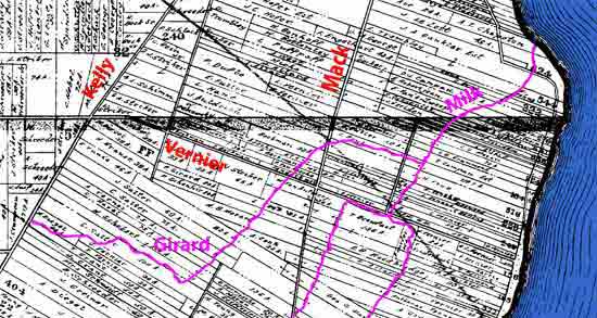
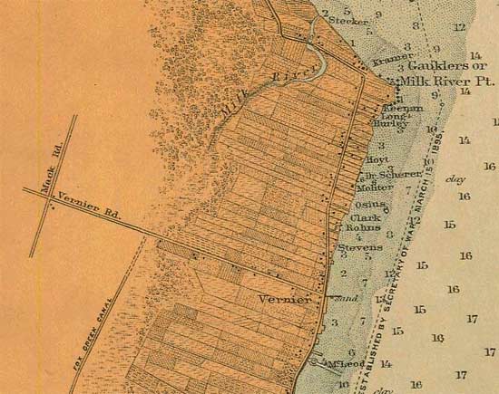
The Milk River through the ages...
This platt map from 1894 shows the Milk and its tributary, the Girard, extending as far inland as Kelly Road, near Moross. The Milk River and Fox Creek nearly meet near Mack and Moross:

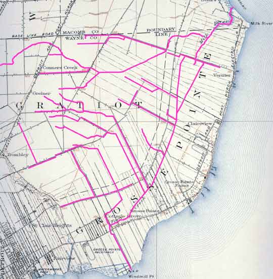
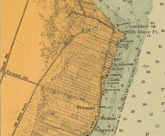
The county dug the Black Marsh ditch circa 1885, connecting the Milk and Fox and helping to drain the Black Marsh area. This topo map from 1911 shows all of the drainage ditches and creeks connecting to the Milk/Girard/Black/Fox system:
1923:
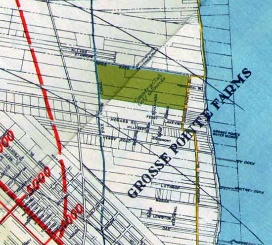
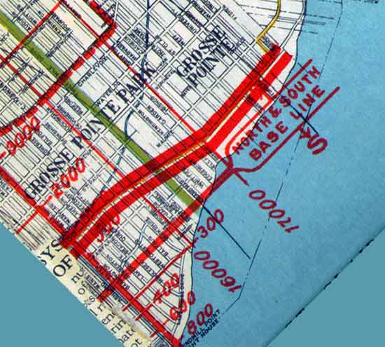
Grosse Pointe sewers dumped into the Black Marsh ditch, and by the 1920s it was considered to be a health hazard. A sewer line was installed and the ditch covered-over by 1930, from Cook Road southward.
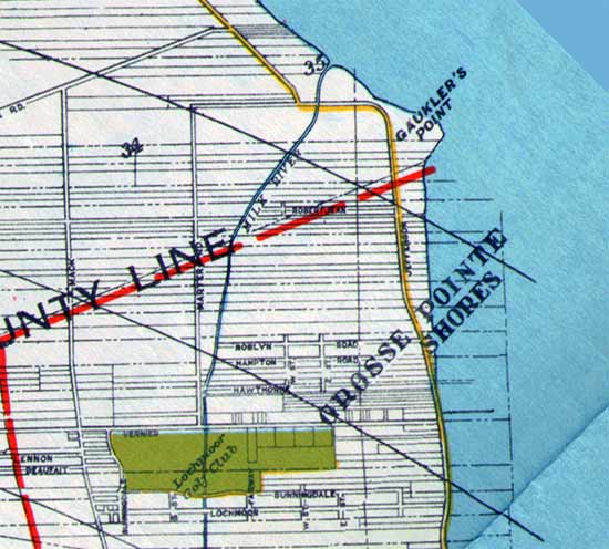
The Milk River remained open from Cook Road northward:
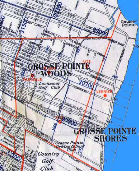
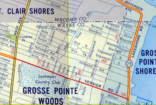
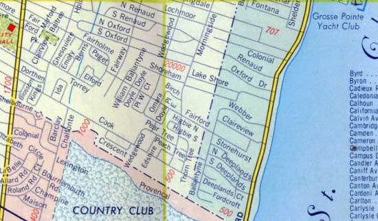
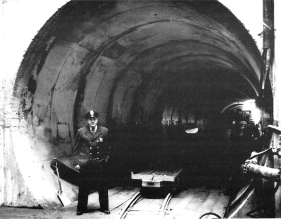
The Grosse-Gratiot Drain project was finished in 1960, and the Milk River ditch was filled in the the following year. A GPW police officer guarding the entrance around Vernier:
|
Tarkus
Member
Username: Tarkus
Post Number: 220
Registered: 04-2006
| | Posted on Monday, January 22, 2007 - 9:07 pm: | |
I had no idea it ran that far Mikem. It looks by the 1885 map you have that Connor Creek spilled into the Milk. It's simply amazing how much has been flattened and covered up. Thanks for all of the responses. |
Harsensis
Member
Username: Harsensis
Post Number: 136
Registered: 07-2005
| | Posted on Monday, January 22, 2007 - 9:38 pm: | |
There is also a neat picture I see from time to time of the construction during the enclosing taken from Kerby looking south. Two of the houses are still there in the picture. I don't think I have a copy of it though. |
Mikem
Member
Username: Mikem
Post Number: 2963
Registered: 10-2003
| | Posted on Monday, January 22, 2007 - 10:04 pm: | |
Tarkus, that one ditch stops just short of Connor's Creek.
Harsensis, I have that picture somewhere but I can't find it.
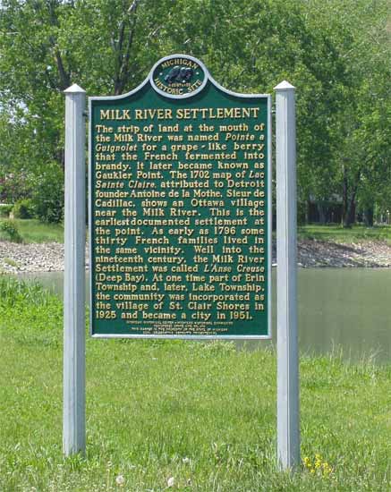
Can't forget to add the Milk River historical marker:
|
Swgz31
Member
Username: Swgz31
Post Number: 37
Registered: 06-2006
| | Posted on Tuesday, January 23, 2007 - 12:23 am: | |
Wow thx for all the info MikeM, being from Grosse Pointe I've always wondered where the Milk River would've gone had it not been covered. |
Mikem
Member
Username: Mikem
Post Number: 2966
Registered: 10-2003
| | Posted on Wednesday, January 24, 2007 - 11:22 am: | |
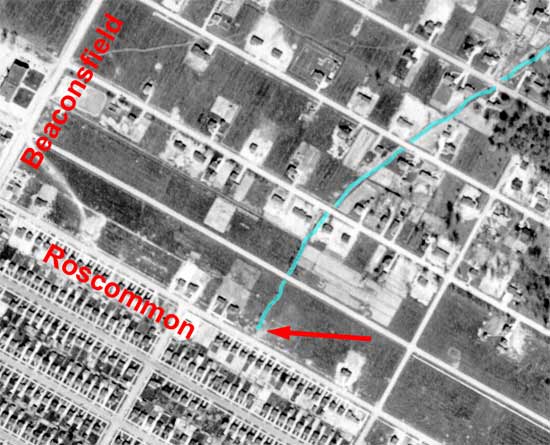
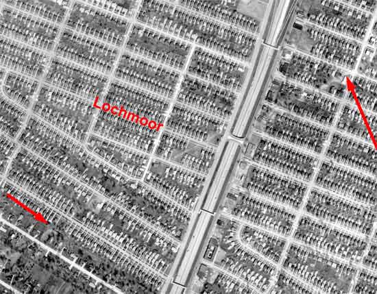
That last map above shows the Girard Drain just south of the county line. Using the Detroit Edison aerial collection from 1949, I traced the drain upstream into Gratiot Township (Harper Woods) as far as Roscommon, just east of Beaconsfield:
http://techtools.culma.wayne.edu/media/wayne/1949/ha-2-79.pdf
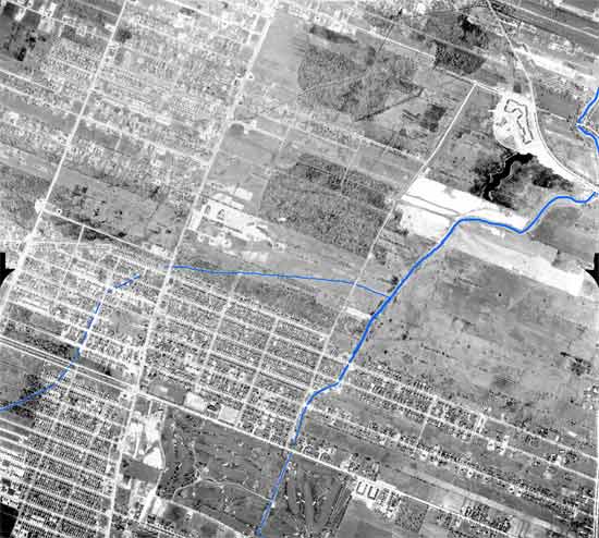
Still a rural area in 1949 where it flowed into the Milk River:
http://techtools.culma.wayne.edu/media/wayne/1949/ha-2-63.pdf
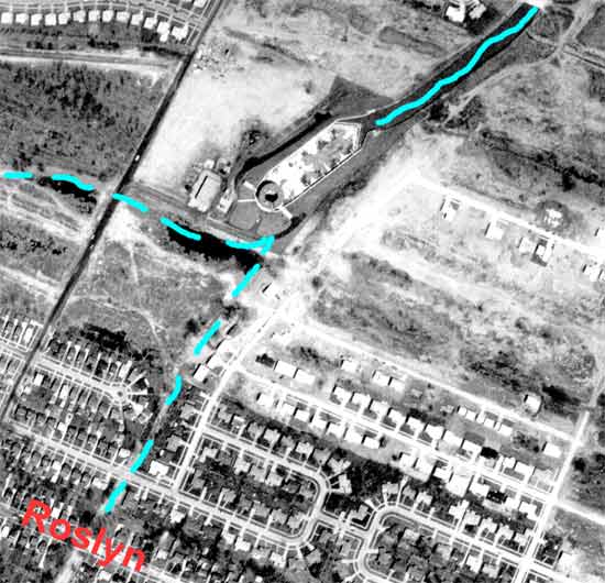
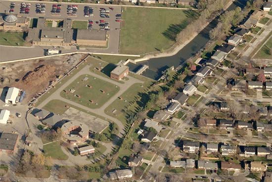
As part of the Grosse-Gratiot Drain Project, the Girard was filled-in or encased and funnelled through the Milk River Pumping Station. The new facility in 1961:
http://techtools.culma.wayne.edu/media/wayne/1961/fm-36-7.pdf
And a trace of the former creek is still visible through Harper Woods, across I-94:
http://techtools.culma.wayne.edu/media/wayne/1961/fm-35-81.pdf
A new covered retention basin has recently been built to replace the old open basin:
|
Courtney
Member
Username: Courtney
Post Number: 109
Registered: 06-2004
| | Posted on Thursday, January 25, 2007 - 2:44 pm: | |
Thanks a million for all the maps and pictures in this thread - you guys rock. Our "new" house is on Rosedale and I've been trying to figure out any historical details I can with almost no free time to do it.
A neighbour down the street had told us of another lifelong resident of the block (between Mack and Helen) having memories of the "Milk River" flowing behind his house, in the area of Avalon St now - I was totally confused as to how it would wind its way here. I'm guessing it was a drain to the Milk from one of the farms that used to be here. |
Harsensis
Member
Username: Harsensis
Post Number: 138
Registered: 07-2005
| | Posted on Thursday, January 25, 2007 - 5:16 pm: | |
Where the Girard Drain crossed the expressway, there use to be a big cement structure there. I only remember it because my brother-in-law spun out after being cut off by the entrance ramp and almost hit it. I don't think it is still there though. |
Ddaydave
Member
Username: Ddaydave
Post Number: 438
Registered: 04-2005
| | Posted on Thursday, January 25, 2007 - 5:45 pm: | |
Courtney I live on Avalon between Helen and Greater Mack and that creek ran right next to my house from what the neighbors have told me ..
theres a manhole cover on my backyard where the the creek is now piped in..
my house was build in 1951 the creek was covered up in 1952
the old timers on the street talk about spearing fish in it ...Dave |
Chitaku
Member
Username: Chitaku
Post Number: 1065
Registered: 03-2006
| | Posted on Thursday, January 25, 2007 - 6:26 pm: | |
I lived on Maxine,between alice and mack, did the river go there? I remember walking to the mouth and following the open part of it a ways |
Lowell
Board Administrator
Username: Lowell
Post Number: 3606
Registered: 10-2003
| | Posted on Thursday, January 25, 2007 - 7:32 pm: | |
Amazing thread! Thanks to all, especially MikeM. I have learned so much from this forum... the Savoyard, Bloody Run, Connors Creek, the Fox and now the Milk. Now I know from where the name L'anse Creuse derives. Slowly the ancient geography of the Detroit is be unearthed in this virtual archeological dig.
MikeM, where is the Milk River historical marker? |
Swgz31
Member
Username: Swgz31
Post Number: 38
Registered: 06-2006
| | Posted on Thursday, January 25, 2007 - 7:38 pm: | |
I'm pretty sure that the historical marker is at the Jefferson bridge over the Milk River. |
Mikem
Member
Username: Mikem
Post Number: 2968
Registered: 10-2003
| | Posted on Thursday, January 25, 2007 - 9:32 pm: | |
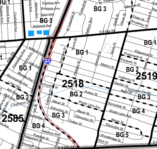
I'm sure there were a lot drainage ditches in the area leading to the Girard or Milk, so if it wasn't the actual river passing through your yard, then it was probably one of the ditches. You can see the Girard crossing Mack just north of Brys in the zoomed-out aerial above. The next major drains to the north were the 8½ Mile Drain and the Chapoton Drain, both of which drain through that pumping station at 9 and Jefferson.
Harsensis, maybe the cement structure was one of the expressway drain pumpimg stations. The freeway drains lead to pumping stations which lift the water into the existing sewer systems. Maybe one is located there to pump that section of I-94 into the Girard.
The historical marker is on the west side of Lakeshore Drive, south of the river crossing. |
Chitaku
Member
Username: Chitaku
Post Number: 1067
Registered: 03-2006
| | Posted on Friday, January 26, 2007 - 3:00 am: | |
is there any history to the name chapoton there? I know the chapoton house on beaubien but there are a lot of things including a street with the name chapoton in scs |
Harsensis
Member
Username: Harsensis
Post Number: 145
Registered: 07-2005
| | Posted on Saturday, January 27, 2007 - 11:48 pm: | |
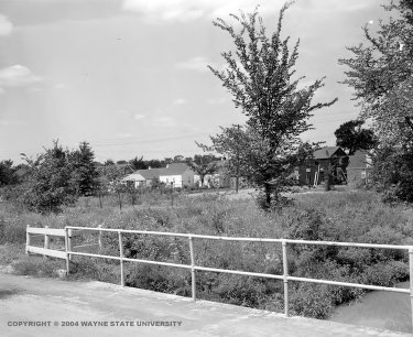
Here is a picture of a bridge over the Milk River from the Wayne State Site.
|
Mikem
Member
Username: Mikem
Post Number: 2979
Registered: 10-2003
| | Posted on Sunday, January 28, 2007 - 1:57 am: | |
WSU labels that picture as "defense worker housing" or something to that effect. Not sure where it was.
Here are two nautical charts showing the Milk River-Fox Creek connection, from 1908 and 1910:
One shows them still separate and the other, connected, although I wouldn't use that as evidence of when the connecting ditch was built, as those details weren't updated with each new chart.
You guys in the south end of St Clair Shores (Chapoton Woods) - I think you are on or near the Chapoton Drain, the next Creek north of the Milk:
East end
West end
|
Courtney
Member
Username: Courtney
Post Number: 111
Registered: 06-2004
| | Posted on Monday, January 29, 2007 - 10:20 pm: | |
Dday - small world, I think I passed by your house area 921572315 times last summer on walks with my 3 year old. If you ever see a girl on Rosedale attacking the front porch and/or foundation with a scraper, say hi, as it's likely me.
Although slightly off topic, our 'hood was originally divided into lots in 1924. The part of Harper that Avalon & Rosedale (at least) runs into was then called Mt. Clemens Drive. Casper and Celestine Decker owned the land, which was bought by the William Z Campbell Land Co.
Although most of this area shows up in city data as being built in 1951, I knew this wasn't the case for ours. Too many details that would be missing in a "working class" home built in 51 were here. The 1930 census shows our house number (and most of the others I'd pegged as older on our street), so unless the area was mass razed and rebuilt in 51, I'm thinking the majority of the area was built by 1930. |
Gistok
Member
Username: Gistok
Post Number: 3531
Registered: 08-2004
| | Posted on Tuesday, January 30, 2007 - 1:25 am: | |
Mt. Clemens Drive was the name for that stretch of Harper starting at Morang continuing NE into St. Clair Shores.
It was changed probably when I-94 went thru there (circa 1960?) although it might have been earlier. Originally Harper followed its' current path, and around Morang it took a bend to the right. That bend today is called Chester Ave. (between Morang and east of Moross into Harper Woods).
I remember about 6 months ago on a thread about east side bus routes where Mikem showed an old street map of the far east side, and right at Morang is where Mt. Clemens Ave. started.
Of course it now no longer exists as Mt. Clemens Ave., since its name was changed for its entire course to Harper Ave. |
Mcwalbucksnfitch
Member
Username: Mcwalbucksnfitch
Post Number: 39
Registered: 10-2006
| | Posted on Tuesday, January 30, 2007 - 2:10 am: | |
It's so interesting to see how streets and urbanization changes to adapt to new freeways/old landforms.
The street my parents are anticipating to move onto isn't even shown on half these maps..."Deeplands"...North of Cook and East of Morningside...maybe the Milk River has something to do with the name Deeplands? |
The_rock
Member
Username: The_rock
Post Number: 1526
Registered: 11-2003
| | Posted on Tuesday, January 30, 2007 - 1:46 pm: | |
McWalbuck---North and South Deeplands are very nice street,and very nice homes, but tell the folks to watch their speedometer as they make the curve down to the lake from South Deeplands. The speed limit there goes from 25 to 15 MPH for the length of the curve, and the Shores needs the money. |
Mcwalbucksnfitch
Member
Username: Mcwalbucksnfitch
Post Number: 40
Registered: 10-2006
| | Posted on Tuesday, January 30, 2007 - 2:41 pm: | |
I have a friend that lives on N Deeplands so I am familiar with the area...and my parents are looking at a home right across the street from my friends' |
Gistok
Member
Username: Gistok
Post Number: 3551
Registered: 08-2004
| | Posted on Wednesday, January 31, 2007 - 11:08 pm: | |
For more nostalgic info on "Mt. Clemens Ave." and pics/maps of the far east side, see the PHOTO OF DSR TERMINUS AT HARPER & MORANG thread. Then click on Mikem's link to an archived thread from last year talking about the far east side (Belgian neighborhood, bus routes, etc).
That was a great thread!!!! |
Tarkus
Member
Username: Tarkus
Post Number: 255
Registered: 04-2006
| | Posted on Monday, February 05, 2007 - 8:21 pm: | |
bump |
Oladub
Member
Username: Oladub
Post Number: 3
Registered: 08-2006
| | Posted on Wednesday, February 07, 2007 - 9:44 pm: | |
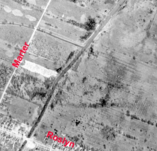
This is a great post. My Father, a carpenter, built a house on Roslyn, west of Mack on one of two vacant lots in 1963. The 1894 map and the 1949 aerial photo show that this was the location of the former Girard Drainage. The other lot was built upon a few years later by another carpenter. Our house was a tri-level so we did not have a full basement. Our sump pump rarely turned on and the lower floor was always dry. |
Chitaku
Member
Username: Chitaku
Post Number: 1113
Registered: 03-2006
| | Posted on Wednesday, February 07, 2007 - 11:10 pm: | |
what is the other canal going through maxine after alice. That would be the house I lived in my lot is a lot and a half so that would explain it |
Mikem
Member
Username: Mikem
Post Number: 3030
Registered: 10-2003
| | Posted on Wednesday, February 07, 2007 - 11:47 pm: | |
Chapoton Drain
Now leads to this building which you might recognize at E Jefferson and 9 Mile:
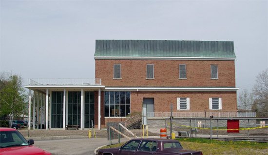
A huge retention basin (28 million gallon) has been built there recently, hidden under all that cement:
|
Chitaku
Member
Username: Chitaku
Post Number: 1114
Registered: 03-2006
| | Posted on Wednesday, February 07, 2007 - 11:58 pm: | |
ok so now my question...why is everything over there named after chapoton? I've searched for answers for ever |
Mikem
Member
Username: Mikem
Post Number: 3033
Registered: 10-2003
| | Posted on Thursday, February 08, 2007 - 12:01 am: | |
One of the platt maps from the 1800s showed a large farm owned by a family named Chapoton. That's my guess. |
Chitaku
Member
Username: Chitaku
Post Number: 1115
Registered: 03-2006
| | Posted on Thursday, February 08, 2007 - 12:02 am: | |
nice....any relation to the Chapoton house on Beaubien I wonder |
Mikeg
Member
Username: Mikeg
Post Number: 551
Registered: 12-2005
| | Posted on Thursday, February 08, 2007 - 12:10 am: | |
My dad was a foreman on the Chapoton Pumping Station and Retention Basin when it was built circa 1967. The building houses a ~90 ft. deep cement-lined caisson (pit) which receives the storm water from the drain. It also houses pumps and piping which move the storm water to the retention basin. When the caisson and its piping were being constructed, the building did not yet exist and they were open to the weather. Right next door was Wally Burkemo's Golf Driving Range and each day, many errant shots would clear the fence and bounce around in the caisson like a ping pong ball. The workers would tend to ignore them since they were protected by hard hats. However, my dad would pick them up on his lunch hour and bring them home in his lunch bucket and give them to me. At the time, I was a high school student who was just taking up the game and I learned to play using a seemingly endless supply of Burkemo range balls. |
Mikem
Member
Username: Mikem
Post Number: 3035
Registered: 10-2003
| | Posted on Thursday, February 08, 2007 - 12:26 am: | |
The Chapoton Basin was expanded during the last summer or two. Water collected there is pumped to the Milk River pumping station and into the Grosse Pointe Interceptor to the pumping station in GP Farms, which pumps it into the old Fox Creek sewer down to the Conner Creek pumping station, where it is pumped through the Detroit River Interceptor to the waste treatment plant on the Rouge River.
Chitaku, looks as if the Chapotons came over on the boat with Cadillac and crew. Must be descendents all over the area. |
Bulletmagnet
Member
Username: Bulletmagnet
Post Number: 27
Registered: 01-2007
| | Posted on Thursday, February 08, 2007 - 11:44 pm: | |
Mikem,I was just wondering: could the excavated soil from any of these projects have been used to build Balduck Hill as I had hypothesized earlier? |
Mikem
Member
Username: Mikem
Post Number: 3039
Registered: 10-2003
| | Posted on Thursday, February 08, 2007 - 11:58 pm: | |
I suppose, but I would think the Fox Creek enclosure would have produced more dirt than that. How large is the enclosure? I think it averages 14' diameter and is about 18,000' long. How high of a dirt pile would that make? |
Bulletmagnet
Member
Username: Bulletmagnet
Post Number: 29
Registered: 01-2007
| | Posted on Friday, February 09, 2007 - 7:49 pm: | |
Well, lets see now...18,000'xE=mc2(14)+FC/MR+ (dirt)...hell, I dunno... |
Danjo444
Member
Username: Danjo444
Post Number: 1
Registered: 02-2007
| | Posted on Tuesday, February 27, 2007 - 1:55 pm: | |
I'm really impressed with how much you guys know about local history. I'm fascinated with this subject, and would like to get a larger color image of the Fox Creek-Milk River circa 1890s-1910 for framing.
I've viewed old Michigan Atlases (I think 1896, and 1906 if memory serves at the Detroit Public Library Burton Collection, and DPL map collections, and also at the GP Historical Society, but they don't let mugs like me take them to a professional for reproducing/enlarging. Any idea where I can get my hands on a Michigan 1896 or 1906 atlas so I could have a page professionally reproduced? I tried John King books, and they had an 1873, but evidently the Fox and Milk were not connected then...maybe a dry year?
MikeM has some great nautical charts above with the connection, but I have no idea where to get my hands on them.
Any help would be greatly appreciated.
PS anyone ever hear of he nun's walk in GPF? |
Fareastsider
Member
Username: Fareastsider
Post Number: 158
Registered: 08-2006
| | Posted on Tuesday, February 27, 2007 - 2:04 pm: | |
I second that where can I get some older maps like MikeM and others have! |
Mikem
Member
Username: Mikem
Post Number: 3121
Registered: 10-2003
| | Posted on Tuesday, February 27, 2007 - 2:40 pm: | |
The old maps I have I've collected from antique stores, used book stores, eBay, etc. None of them would be suitable for framing; too many tears, creases, pencil markings, etc.
A few of the turn of the century atlases can be found here:
Michigan County Histories
The old NOAA charts can be found at this link:
Historical Map & Chart Project
A search on Detroit and/or St Clair will produce a list of about two-dozen charts. You'll have to view each one individually to find what you want. To view the charts you will need the MrSID plug-in. The link to the software is at the bottom of the page.
If you want a frame-worthy paper version of an old atlas or topographic chart, you're probably out of luck unless you find one on eBay or in an estate sale. |
Gannon
Member
Username: Gannon
Post Number: 8435
Registered: 12-2003
| | Posted on Tuesday, February 27, 2007 - 2:40 pm: | |
So Cadillac had what, 40 people on his boats...we now learn that one family took over a load of the eastside, and we have two descendants of others on this very forum...Kathleen and Skulker.
Wouldn't it be fun to just plot the family trees of those original 40 people...see how they filter through to 2007. |
Fareastsider
Member
Username: Fareastsider
Post Number: 161
Registered: 08-2006
| | Posted on Tuesday, February 27, 2007 - 3:28 pm: | |
Thank you Mike! |
Danjo444
Member
Username: Danjo444
Post Number: 2
Registered: 02-2007
| | Posted on Tuesday, February 27, 2007 - 11:11 pm: | |
I second that emotion FarEastsider. MikeM, I found some great stuff on those links. Thanks |
Mikem
Member
Username: Mikem
Post Number: 3138
Registered: 10-2003
| | Posted on Friday, March 02, 2007 - 9:51 pm: | |
Thanks BM! I understand that building was designed by Albert Kahn:
I live nearby - you give tours? |
Gistok
Member
Username: Gistok
Post Number: 3727
Registered: 08-2004
| | Posted on Saturday, March 03, 2007 - 9:45 pm: | |
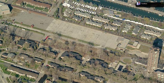
I remember as a kid in the early 1960's going to Jefferson Beach (9 Mile & Jefferson), which was located along the waterfront where the Chapoton Pumping Station and retention basin are now located. Does anyone know if the beach was closed because of the Chapoton complex?
I still remember the long row of huge Weeping Willow trees all along the canal just south of beach. For a kid, they were a very impressive sight. |
Bunkster
Member
Username: Bunkster
Post Number: 6
Registered: 02-2006
| | Posted on Tuesday, March 20, 2007 - 3:06 pm: | |
Cool: For two years I lived on Belanger right near Chalfonte and Kerby.
One of my neighbors lived there her entire life and had a picture of her house and the large drainage ditch/pipe around the corner. |
Harsensis
Member
Username: Harsensis
Post Number: 196
Registered: 07-2005
| | Posted on Tuesday, March 20, 2007 - 10:22 pm: | |
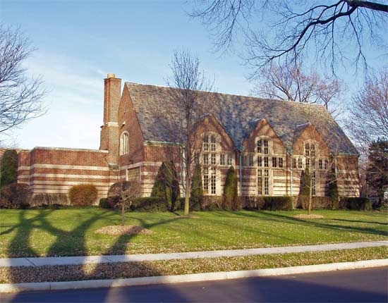
The Nuns Walk is on Kenwood between Kercheval and Grosse Pointe Blvd.
It is fun to have people ask about the church in the above picture, and then tell them that it is our sewage pumping plant. |
Chalu64
Member
Username: Chalu64
Post Number: 142
Registered: 08-2005
| | Posted on Wednesday, March 21, 2007 - 4:44 pm: | |
It's the cross-shaped windows on that building. |
Bulletmagnet
Member
Username: Bulletmagnet
Post Number: 154
Registered: 01-2007
| | Posted on Tuesday, March 27, 2007 - 5:53 am: | |
Here is the vernal pond at Moross and Chalfonte:
http://i148.photobucket.com/al bums/s22/bulletmagnet69/kodakg roup032607005.jpg?t=1174988525
(disregard time stamp) |
Harsensis
Member
Username: Harsensis
Post Number: 203
Registered: 07-2005
| | Posted on Tuesday, March 27, 2007 - 9:36 pm: | |
And as soon as those leaves pop out of those trees, all that water will be gone! I have heard some of the neighbors complain about the ponding of the water and the person who lives there puts them off until the water is gone. |
Bulletmagnet
Member
Username: Bulletmagnet
Post Number: 159
Registered: 01-2007
| | Posted on Tuesday, March 27, 2007 - 9:49 pm: | |
The homeowner uses a French well to drain the pond. A pair of Mallards can often be seen here. Some may complain, but it really is a unique pond. |
Harsensis
Member
Username: Harsensis
Post Number: 210
Registered: 07-2005
| | Posted on Saturday, March 31, 2007 - 11:11 pm: | |
Bullet, Where does the French well drain to? Or does it just have a gravel hold to help drain the water down into the soil? Does that house have a basement? I remember walking through the house next door on Moross when I was a kid and it was being built in the late 70's. I don't recall seeing a basement on that house, but I was pretty young when I did that. |
Bulletmagnet
Member
Username: Bulletmagnet
Post Number: 171
Registered: 01-2007
| | Posted on Sunday, April 01, 2007 - 12:26 am: | |
Dont know about the basement Harsensis.I was in that house loong ago and it impressed me as being on a slab. The well is dug in the lowest part of the pond. A pump is placed in the bottom (in this case an electric pump) and it in filled in with course gravel. The water can be pumped out lickity split. |
Ntrance
Member
Username: Ntrance
Post Number: 14
Registered: 02-2007
| | Posted on Thursday, April 05, 2007 - 12:00 am: | |
This thread is so intriguing that it gave me an idea for my senior research project. I am finishing my degree in Landscape Architecture at Michigan State (mid-life career change). When I lived in Harper Woods, every once in a while someone would mention the "Milk River running through the back yard" or something like that. Now I know a bit more, and thank everyone for uncovering the facts.
For my project, I want to explore the notion of "daylighting" the Milk River. That is, uncovering the covered portions, and to what extent. Surprisingly we don't cover much on the subject at school, so it's a chance to stretch the brain a bit.
I would very much welcome your feedback and comments, particularly from current/former residents who have/had some form of interaction, whether you skated on the frozen river or like The_Rock who has to pay for it.
I've had a chance to back-check some of the stuff MikeM posted at the State of Michigan library. The Gratiot-Grosse Drain project has a number of brief stories in the GP News. As an aside, this was in the thick of the Dutch Elm disease battle. |
Ntrance
Member
Username: Ntrance
Post Number: 15
Registered: 02-2007
| | Posted on Thursday, April 05, 2007 - 12:05 am: | |
Can anyone give me places to go or publications to check on:
1) What connections are made to the Girard Drain and Milk River (current/previous storm and sanitary connections)
2) The history of the funding for the project, and why Rock and others are still paying for it. Is it maintenance, or paying off old bonds?
3) Construction photos
Thanks in advance. Whatever I find I will share here. |
Swgz31
Member
Username: Swgz31
Post Number: 42
Registered: 06-2006
| | Posted on Thursday, April 05, 2007 - 12:38 am: | |
I remember growing up, me and my friends go to the bridge at Rosedale street in SCS and go on the banks and fish for crayfish. There used to be a ton of them down there under all the rocks. We'd catch them using slim jims of all things haha. They were great to catch bass and other fish with in Lake St Clair. |
Mikeg
Member
Username: Mikeg
Post Number: 773
Registered: 12-2005
| | Posted on Thursday, April 05, 2007 - 8:29 am: | |
Ntrance,
The Grosse Pointe Public Library has digitized back issues of the Grosse Pointe News available on-line here.
The digitized PDF files are searchable by keyword and include back issues from 1940 to present. |
Harsensis
Member
Username: Harsensis
Post Number: 225
Registered: 07-2005
| | Posted on Thursday, April 05, 2007 - 6:36 pm: | |
I pointed out the Mallard mamma and poppa to my kids yesterday when they were swimming around in the pond
I'm sure the GP Historical Society has some pics of the tube. |
Bulletmagnet
Member
Username: Bulletmagnet
Post Number: 222
Registered: 01-2007
| | Posted on Sunday, April 08, 2007 - 9:00 am: | |
Sounds like an interesting project Ntrance. You have come to the right place for starters. I have gotten a good education on this topic by reading and rereading this thread. Those who have posted the information here have true passion. Best of luck on your work, and please keep us posted. Thanks for the Mallard update Harsensis. Correct me if I am wrong, but ducks mate for life. So, we may say that these are the same pair from year’s past? (photos?) |
Bulletmagnet
Member
Username: Bulletmagnet
Post Number: 223
Registered: 01-2007
| | Posted on Sunday, April 08, 2007 - 9:20 am: | |
This is way off topic, but in rereading this thread Danjo444 asked about and Harsensis located the Nuns walk on Kenwood in the Farms. Here are a few belated shots for you:
http://i148.photobucket.com/al bums/s22/bulletmagnet69/kodakg roup032607110.jpg?t=1176037577
http://i148.photobucket.com/al bums/s22/bulletmagnet69/kodakg roup032607105.jpg?t=1176037618
http://i148.photobucket.com/al bums/s22/bulletmagnet69/kodakg roup032607102.jpg?t=1176037650
Again; my apologies for the off-topicness. |
Tarkus
Member
Username: Tarkus
Post Number: 319
Registered: 04-2006
| | Posted on Saturday, April 28, 2007 - 5:45 pm: | |
<bump> |
Dalboz1
Member
Username: Dalboz1
Post Number: 1
Registered: 03-2008
| | Posted on Sunday, March 09, 2008 - 12:49 am: | |
I lived on Aline Drive in Grosse Pointe Woods from 1954-1961. An off shoot of the Milk River(we called it Milky creek) ran in back of us along present day Blairmoor Ct. One of the 'rites of passage' for my friends was to go under the drain pipe that ran under the bridge at Goethe Rd. The Creek had paths along both sides of it and at one point a fallen tree spanned the creek. The creek took what ever overflow the Milk river couldn't handle and we used to catch polliwogs in the drain field puddles. The creek ran from Marter Rd to Mack Ave. and cut quite a slice before it disappeared under Mack. I was too young to cross Mack. If any of the old Aline dr. crowd(Detloff, Rabaut's, Gregory's, Kaucheck's, DeGentner, Kirby
are still around(alive).I'd like to hear from you.
I'm John Abeli |
Dalboz1
Member
Username: Dalboz1
Post Number: 2
Registered: 03-2008
| | Posted on Sunday, March 09, 2008 - 1:06 am: | |
I remember the Milk running as far as Oxford Rd. My grandma used clean house for a family right on the river which was barely a ribbon of green water at that point(e) |
Dalboz1
Member
Username: Dalboz1
Post Number: 3
Registered: 03-2008
| | Posted on Sunday, March 09, 2008 - 1:24 am: | |
I had a friend that lived on Roslyn Rd. between Marter Rd. and Wedgewood,right on the banks of the Milk river before it was filled in. The wide part of the river at that point ran from Vernier under Anita, Hollywood, Hampton,Hawthorn, Roslyn and Brys Dr. Aline Drive ended at a circle drive and the River ran in back of that to the Marter Rd. station and points beyond. the Milk ran under the Lochmoor Country Club but was never as wide after it hit Sunningdale. |
Dalboz1
Member
Username: Dalboz1
Post Number: 4
Registered: 03-2008
| | Posted on Sunday, March 09, 2008 - 3:21 am: | |
Notice to 'The Rock' I moved from Aline to Saddle Ln. right next to the Hunt Club. we used to play in the Gazebo at the old Schlotman estate. My folks still have a wall separating their property from the Shelden estate on Provencal. |