Fareastsider Member Username: Fareastsider Post Number: 346 Registered: 08-2006 |
I found a 1935 county road map for Macomb and found a proposed "Imperial Hwy" it was never built. Seems like a wierd route...anybody know anything about this??? here are some images of the map it is the dashed black line. http://i141.photobucket.com/al bums/r50/fareastsider/Maps/Gua rdian043.jpg http://i141.photobucket.com/al bums/r50/fareastsider/Maps/Gua rdian045.jpg http://i141.photobucket.com/al bums/r50/fareastsider/Maps/Gua rdian042.jpg http://i141.photobucket.com/al bums/r50/fareastsider/Maps/Gua rdian044.jpg | ||
Ro_resident Member Username: Ro_resident Post Number: 221 Registered: 11-2003 |
Mmm, I wonder if it is related to this road in Westland (Ford and Wayne Roads). I lived in the neighborhood for a short period of time. http://maps.google.com/maps?f= q&hl=en&q=westland,+michigan&l ayer=&ie=UTF8&z=17&ll=42.32231 ,-83.38563&spn=0.005894,0.0099 78&om=1&iwloc=addr | ||
Fareastsider Member Username: Fareastsider Post Number: 347 Registered: 08-2006 |
you know what there is one in Redford as well now that I think of it. It is E. of Beech Daly and runs off of Grand River | ||
Ray1936 Member Username: Ray1936 Post Number: 1367 Registered: 01-2005 |
In 1935 it woulda just crossed a lot of farm land. Interesting find. | ||
Patrick Member Username: Patrick Post Number: 4270 Registered: 10-2003 |
seems like it is going from Utica to Armada? | ||
Ericdetfan Member Username: Ericdetfan Post Number: 50 Registered: 02-2007 |
Thats a pretty useless route for a highway, even for todays standards. | ||
Professorscott Member Username: Professorscott Post Number: 302 Registered: 12-2006 |
OK, Ericdetfan, I agree; but I have the same opinion of M-53 from 18 1/2 Mile Road to 34 Mile Road. At least the Imperial Highway would have gone from one city to another. Being from New York originally, you wouldn't believe the highways our well-intentioned officials planned over the decades and thankfully abandoned. Around here it seems you built damn near all of 'em. | ||
Fareastsider Member Username: Fareastsider Post Number: 348 Registered: 08-2006 |
IT goes from 17/Dequindre to 31/Gratiot near Richmond. Im wondering if Ro_resident is onto something I can see a line going from 17/Dequindre to the REdford Imperial Hwy to the one in Westland. | ||
Gsgeorge Member Username: Gsgeorge Post Number: 134 Registered: 08-2006 |
Ro_Resident, it looks like the Imperial Hwy of your neighborhood may indeed be a "leftover" of some of the first grading done for the other end of some kind of proposed route, possibly planned to connect to the Imperial Hwy out in Macomb. If you switch to the satellite image, you'll notice that the Imperial Hwy in your neighborhood 'continues' outwards northeast-southwest -- trees have been cleared and other sections of subdivisions and parking lots follow the grading. You'll see some of this out in Oakland County as well, where they stopped building a road years ago but the preliminary grading has still had an effect on the landscape. In fact, up by Utica you can see a diagonal clearing cutting through the suburbs north of M-59. Take a look it may be the grading from another proposed highway or the one seen on the map. There is another similar diagonal just east of this one. Zoom in to get a better impression of how they influence the modern road layouts in the otherwise winding and random suburban developments. (Message edited by gsgeorge on April 26, 2007) | ||
Gsgeorge Member Username: Gsgeorge Post Number: 135 Registered: 08-2006 |
OF COURSE, these are POWER LINE routes. Zoom in and look for the towers. Perhaps the route was cleared for a highway but later changed to accommodate utilities. | ||
Gistok Member Username: Gistok Post Number: 4196 Registered: 08-2004 |
It sorta reminds one of the unfinished portions of the Davison Freeway. The I-94/Conner interchange is so strange because that is where the Davison Fwy. was one day going to have an interchange with I-94 (where the Davison was to end). The cleared parkland along portions of Conner Ave. just north of I-94 are another (future freeway) section that was left cleared, and used as parkland. It was going to follow Conner, and eventually connect with the route that Davison Ave. followed. I assume that it was going to follow 6 Mile Rd. at some point, possibly between Mt. Olivet Cemetery & City Airport, but I'm not 100% sure on that one. | ||
Blueidone Member Username: Blueidone Post Number: 52 Registered: 03-2007 |
Many years ago when I lived in Washington Twp. I remember hearing that there was a proposed highway that would run along Mound Road north from I-696 to Utica and northeast from there toward Port Huron. Then they built the M-53 and M-69 highways; then the connector from Mound Road to M-53. The connector sort of follows that route on Fareastsider's map in the beginning. | ||
1953 Member Username: 1953 Post Number: 1353 Registered: 12-2004 |
Connecting the Davison to I-94 would make sense to me. I always wondered what the point of that useless little freeway was... | ||
Planner_727 Member Username: Planner_727 Post Number: 100 Registered: 07-2006 |
1 - The Davison was built to provide access from neighborhoods and residential areas to the west of Highland Park, where tens of thousands of line workers went to work every day. Lots of old photos (I'll look for one) of the streets packed at each shift change. 2 - The same reason that the conner interchange is over-built is why the Mound/I-696 interchange is freeway-style. The freeway system was planned to connect Davison to Conner-I-94 (would be I-294?), and then also where the 'bend' of the extended Davison was, M-53 highway would go up mound road to connect to the Van Dyke Hwy, which starts at 18 1/2 mile. I have old State trunkline maps, I'll try and scan them in and post soon. Other interesting routes include I-96 (along schoocraft) being the M-14 freeway, while I-96 followed Grad river all the way out through where the M-5 freeway is. More to come!! | ||
Fareastsider Member Username: Fareastsider Post Number: 349 Registered: 08-2006 |
I dont think that the diagonal area found in Macomb is relate. It is off over a mile from the original route and the angled line runs directly to the Transmission lines that run between Hoover and Schoenherr to 8 mile. I think that is just by chance that it looks similar. I have never seen a plan for this hwy on any subdivision plat in Macomb and I have seen hundereds of them. I dont think it got very far out here. There may be some left over marking on it on the landscape but I dont think that the power lines follow the planned route of the Imperial Hwy. | ||
Ro_resident Member Username: Ro_resident Post Number: 223 Registered: 11-2003 |
I found another stub of Imperial Highway in Redford. Using a straight edge, it pretty well lines up with the stub in Westland. http://maps.google.com/maps?f=q&hl=en&q=redford,+michigan&layer=&ie=UTF8&z=16&ll=42.432801,-83.290894&spn=0.011767,0.019956&om=1 One highway that didn't get build is the M-10 connection to M-59. Interestlingly enough, the official MDOT map still shows the diagonal connector from M-5/Pontiac Trail to M-59. 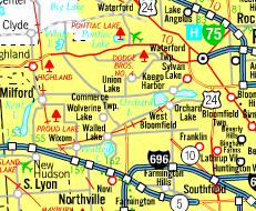 (Sorry if this is a double post) |