Babamary Member Username: Babamary Post Number: 1 Registered: 08-2007 |
Does anyone have any ideas where this photo might have taken? It is probably the late 1930s or up to 1941 (subject was in the Army after that), and because he lived in Hamtramck, it probably is that area? Clues to check out: the landscape dips behind him (near a freeway?), tall building (offices or factory?), building/factory with smokestacks, trestle bridge in far left background. Maybe if you have an older relative that might have lived there in that time period, you could show it to them? Thanks. 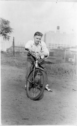 | ||
Johnlodge Member Username: Johnlodge Post Number: 2087 Registered: 10-2003 |
Is that Russell Industrial in the background? | ||
Buzzman0077 Member Username: Buzzman0077 Post Number: 103 Registered: 11-2006 |
^That's what I thought. | ||
Hornwrecker Member Username: Hornwrecker Post Number: 1887 Registered: 04-2005 |
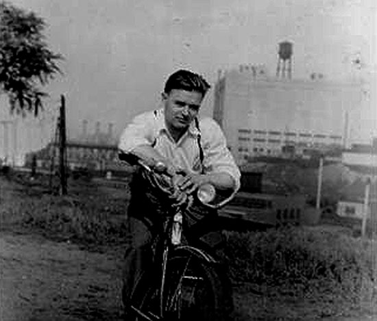 | ||
Stinger4me Member Username: Stinger4me Post Number: 7 Registered: 08-2007 |
My guess would be the south end of Hamtramck near the border with Detroit. | ||
Jimaz Member Username: Jimaz Post Number: 3038 Registered: 12-2005 |
Thanks, Hornwrecker. Could that "landscape dip" be a railroad? It looks like it might have some kind of railroad car in it. It sure would help if we had a database of all the water tower locations. It's amazing how often they turn up in these old photos. | ||
Jimaz Member Username: Jimaz Post Number: 3039 Registered: 12-2005 |
The tallest building seems to have crenelations on top of the little rooms on its roof. Is that just from Hornwrecker's enhancement? I think I can see them in the original too. | ||
Rfban Member Username: Rfban Post Number: 176 Registered: 02-2004 |
I am sure that the building in the back ground is located on Ferry st. a few blocks from Hastings. The question is photo shot from the North or the South? Judging by the shadows he is either riding his bike in the morning or in the evening depending on if he is north or south of Ferry. | ||
Hornwrecker Member Username: Hornwrecker Post Number: 1890 Registered: 04-2005 |
There was a Cadillac factory at Riopelle and E Warren. Photos on page two of the OCF: https://www.atdetroit.net/forum/mes sages/6790/40008.html?11109346 26 That could be the building. Still trying to figure out what,where, why of the elevation the photo was taken from. | ||
Rfban Member Username: Rfban Post Number: 177 Registered: 02-2004 |
I really think he is north, not south of E. Ferry. He would most likely be in the Poletown cadillac plant now. That building is on Ferry, i am confident of that. | ||
Gazhekwe Member Username: Gazhekwe Post Number: 136 Registered: 08-2007 |
Davison was the first freeway, and opened in late November, 1942. I vote for railroad. | ||
Cherry Member Username: Cherry Post Number: 11 Registered: 09-2004 |
I think he just north of Ferry, between the Dequindre Cut and the incinerator. The building on the right is on the corner of Ferry and Roby, and the building in the distance near his right elbow may be St. Stanislaus. | ||
Dodgemain Member Username: Dodgemain Post Number: 175 Registered: 04-2005 |
I think the building is correct but He is on the south side. A Sanborn map should ID the building thats on a angle. I cant find it in the 1949 DTE maps. | ||
Cherry Member Username: Cherry Post Number: 12 Registered: 09-2004 |
I'm very interested to see the map. I was in the area today, and I think he was definitely somewhere on the grounds of the incinerator, north of Ferry. Here is a photo taken from the driveway: http://defcode.com/wiki/index. php/Image:Dscf7094.jpg If you look at the full resolution version, you can see St. Stanslaus through the trees. Here is another photo showing my position in relation to the guard shack. http://defcode.com/wiki/index. php/Image:Dscf7099.jpg Was the incinerator built on a hill? It seems like everything would have lined up perfectly if I could have stood where the stack is now. | ||
Civilprotectionunit4346 Member Username: Civilprotectionunit4346 Post Number: 360 Registered: 06-2007 |
That's the Grand Trunk building in the background there. It's abandonded right now and there was a fire inside of it at one time. | ||
Babamary Member Username: Babamary Post Number: 2 Registered: 08-2007 |
You guys are awesome! This is way bigger response than I thought I would get...but I have some questions, still! Since I lived in Detroit area only from age 4 to 16, I never became well acquainted with streets (didn't have a drivers license yet!). So: Where exactly is this incinerator located? is it a separate business or part of one of the factories there? What would be the closest streets to its location? Is the Grand Trunk a railroad building or other business? What would be the street(s) nearest it? I am trying to figure out the possible reasons why this photo was taken there: my thought is that this was a Sunday ride around the area (my uncle would have been working during the week, and I believe before WWII a lot of people still worked six days a week), especially since he is in white shirt. I am attaching another photo that might have been taken the same day; all the guys (I would hazard that they are friends) are in dress shirts, some in ties (Uncle was a baker by trade, so that is not work wear for him). He lived on Porter in the 5200 block; might have gone to the Ukrainian Catholic Church in Hamtramck (there are two I see listed, but I don't know if both would have been there in 1937-1941). In the photo of these friends, maybe someone would be able to tell if Hamtramck had benches and wide "right of ways" - there appears to be a sidewalk at their feet (unless it is a parking lot), some are sitting on a bench (bus stop? park? or just a convenient bench placed by a business?) but there is still a bit of grass before the fence of the house behind them. 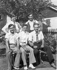 | ||
1953 Member Username: 1953 Post Number: 1450 Registered: 12-2004 |
My first reaction was Grand Trunk Railroad building. | ||
Detroit_stylin Member Username: Detroit_stylin Post Number: 4816 Registered: 10-2003 |
 does the area look familiar anyone? (Message edited by Detroit_stylin on August 27, 2007) | ||
Karl_jr Member Username: Karl_jr Post Number: 72 Registered: 06-2007 |
Grand Trunk Building = Cold Storage for reefer car perishables. | ||
Civilprotectionunit4346 Member Username: Civilprotectionunit4346 Post Number: 376 Registered: 06-2007 |
The incinerator located next to it has a funky smell to it when I was in the neighborhood. I believe the building is for sale at this present time. Speaking of buildings for sale, the Packard Plant has a for sale sign on it at this time. | ||
Cherry Member Username: Cherry Post Number: 13 Registered: 09-2004 |
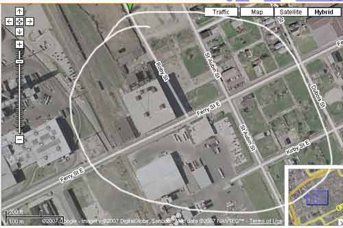
Babamary: give this link a try: http://maps.google.com/maps/ms ?ie=UTF8&hl=en&t=h&om=1&msa=0& msid=108629663997852616290.000 438baf22320b4d0829&ll=42.37791 7,-83.05162&spn=0.024823,0.035 491&z=15 You are probably right that they were out for a ride after church. Immaculate Conception was on Grayling Street, between Joseph Campau and Lumpkin, until the mid to late 40's. I don't think the second photo was taken in Hamtramck. |