Ltdave Member Username: Ltdave Post Number: 26 Registered: 09-2006 |
what exactly is this? ive seen the satellite picture and it appears to be an old storm drain like the concrete drains in LA... david | ||
Douglasm Member Username: Douglasm Post Number: 754 Registered: 10-2003 |
It was a people and freight drain. The cut carried the Grand Trunk Western commuter and freight rail from Brush Street Station and the ferry dock at Robin Hood Flour out past the Eastern Market. It will take someone else to tell exactly where the cut ends on the north side. I'd be leaning towards Grand Boulevard because after Milwaukee Junction, the track runs at grade. Now, If you don't know where Brush Street Station, the ferry dock or Robin Hood Flour were, you're on your own. | ||
Livernoisyard Member Username: Livernoisyard Post Number: 2192 Registered: 10-2004 |
For choo-choo tracks some forty? feet below grade. Used to go to the Brush Street Station near the Ren Cen. At one time, those tracks were at grade and interferred with street traffic. In 1850, the Dequindre ribbon farm out to near Milwaukee Junction was about where the city line was on the east (Orleans/St. Aubin/Dequindre). (Message edited by livernoisyard on January 20, 2007) | ||
7milekid Member Username: 7milekid Post Number: 172 Registered: 01-2006 |
its amazing down there, u gotta check it out. Your prolly gonna run into naked bums like we did but its pretty fun. | ||
Sticks Member Username: Sticks Post Number: 186 Registered: 08-2005 |
Douglasm, I'd say a safe cut-off point on the north side is Mack/MLK. On the south end, it pretty much ends at E Jefferson. Bums usually actively occupy the two northern most viaducts as well as the gutted building on the east side of the cut between the second and third viaducts. They're usually pretty chill but it wouldn't hurt to give them a smoke if they ask for anything. And always carry some sort of weapon if you're paranoid. Scattered rail spikes, debris from abandoned cars, and empty spray cans are quick to be found. Also, like other's have said, it's an abandoned rail line. There are still rails and ties in places but no trains run through the cut. North of Mack/MLK, however, I've seen a couple reefers thus making the line active and not part of the cut (at least in my mind). (Message edited by Sticks on January 21, 2007) | ||
Douglasm Member Username: Douglasm Post Number: 755 Registered: 10-2003 |
There was a long discussion about the cut about a year ago that would probably help David out. Could someone with more computer skill than I dig it out and post a link? | ||
Gannon Member Username: Gannon Post Number: 7949 Registered: 12-2003 |
I've been TWO BLOCKS from this thing for over a year now...and the most I know about it is how to avoid the huge potholes on that Wilkins Street overpass. Saw surveyors in it last summer while I was jogging, the street just west of it alongside the Lafayette Park area became one of my favorite routes either to Belle Isle or Hart Plaza. I'm sure when the cut renovation is completed, it'll be my local mini-Hines Drive right on down to the Riverwalk. Wonder if that survey information is available on-line...I'd love to see the elevation from the river. | ||
Tetsua Member Username: Tetsua Post Number: 1060 Registered: 01-2004 |
quote: What up Sticks ... This has got to be the most ghetto post of January.  | ||
Lowell Board Administrator Username: Lowell Post Number: 3586 Registered: 10-2003 |
Best gallery of local art anywhere with constantly changing exhibitions. And, unlike the DIA, you can touch the art. Don't like it? Paint it over with your own work. Winter is actually the best time to visit as the vegetation, which obscures much of the work in the summer, is gone. Note to self, time for a revisit. Chronicled twice on DetroitYES since the late 90's: https://www.detroityes.com/webisode s/2002/020921Lascaux00.htm https://www.detroityes.com/art/03ca ve_entrance.htm | ||
Charlottepaul Member Username: Charlottepaul Post Number: 294 Registered: 10-2006 |
Any of you all suppose that artists will still be able to use the cut as a canvas after the proposed renovations of it into a walking path? | ||
Cozmikdebris Member Username: Cozmikdebris Post Number: 98 Registered: 10-2003 |
quote: I personally don't consider encountering naked bums "fun," and would be inclined to steer clear of the area, in the summer at least. YMMV. | ||
Mikeg Member Username: Mikeg Post Number: 481 Registered: 12-2005 |
More information about the proposed development of the Cut for pedestrian use can be found here. Here are a few nuggets about the Cut from the St. Joseph's Parish "History Corner": September 11, 2005 - I also remember hearing that one of the earlier parish buildings (possibly the original rectory) caught fire and burned to the ground due to an ember ejected from a passing train. | ||
Rfban Member Username: Rfban Post Number: 29 Registered: 02-2004 |
My great grandfather worked in a limestone quarry in a small village just outside of Rome, Italy. The name of the city is Civita Castellana. When they immigrated in the early 1900's he got a job at the Sibley Quarry. Thank you very much Mikeg, I found that very interesting. | ||
Archinnovator Member Username: Archinnovator Post Number: 9 Registered: 12-2006 |
As an interesting aside, I emailed the artist who painted the Pirates of the Caribbean inspired piece under one of the overpasses (I assume it's still intact, I was down there in October), and he's a graffiti artist from Tulsa, OK who was visiting his brother here when he created the piece. His website is eratikone.com if anyone's interested. | ||
Fishtoes2000 Member Username: Fishtoes2000 Post Number: 162 Registered: 06-2005 |
I learned today that the sewer line issue has been resolved, and with some luck, bids will be let this spring for the next phase of construction. | ||
Charlottepaul Member Username: Charlottepaul Post Number: 319 Registered: 10-2006 |
Next phase? Of the Dequindre Cut? What was the first phase? | ||
Fishtoes2000 Member Username: Fishtoes2000 Post Number: 165 Registered: 06-2005 |
I believe they did some cleanup using DEQ brownfield monies early on. Not sure where it was or what they cleaned up, but I remember being told that that was the first step. | ||
Leland_palmer Member Username: Leland_palmer Post Number: 211 Registered: 08-2004 |
Here's one of my shots from further up near Eastern Market. http://www.flickr.com/photos/t heblacklodge/257997356/ | ||
Ordinary Member Username: Ordinary Post Number: 120 Registered: 06-2006 |
Leland_palmer, Did you take that picture? It's very cool. Is it looking toward Gratiot, or is Gratiot behind the photographer? | ||
Leland_palmer Member Username: Leland_palmer Post Number: 212 Registered: 08-2004 |
The photo was taken North of Gratiot, on Adelaide, looking North. | ||
Quozl Member Username: Quozl Post Number: 204 Registered: 07-2005 |
Nice Flickr album Dubs'. | ||
Patrick Member Username: Patrick Post Number: 3997 Registered: 10-2003 |
Is the cut polluted at all? With all those heavy-industrial centers nearby there had to have been exposure to dangerous chemicals etc. | ||
Leland_palmer Member Username: Leland_palmer Post Number: 214 Registered: 08-2004 |
Thanks Quozl. I'm suffering from a bout of split personality. I started to use A Dubs on flickr and my blog. Http://fadeddetroit.com | ||
Waxx Member Username: Waxx Post Number: 31 Registered: 09-2006 |
Here's something that U may like. i had an old Texaco map of the city [it was tattered and that's why I no longer have it =-(. I was in the 7th grade and had no idea that it was priceless in its tattered condition-it was a gift from my social worker-I wish I still had it 2day]. But my point is this. This treasure had the eastside on one side, and the westside on the other side-that's how big it was. Just some features that the older ones here can recall: The Lodge stopped @ Wyoming-which explains why James Couzens is a narrow as it is Edsel Ford stopped @ Vernier and Harper Where Fisher Fwy. is between Michigan and Gratiot was Vernor Highway Chrysler ended @ Warren [or Mack] Southfield was a divided highway that made a point @ 9 Mile and Northwestern [the map I had went up (slightly past) to 9 Mile] There was no Jefferies Fwy. yet. (the map only showed it being under construction) Up to that point, Schoolcraft was a divided highway 1/4 mile west of Evergreen Evergreen ended-or made a point-@ Hubbard Drive Davison Fwy. originally routed from the Railroad Track that divided Detroit from H.P. to the Lodge There was no Dearborn Heights yet-I could be wrong, but it was then the far east part of Garden City Oakland became Stephenson @ 8 Mile And last but not least, Dequindre ended @ Atwater (before it became a transit route) And if anyone's noticed in the last few years Dequindre was reopened or re-extended from Warren to Mack. I know that most of all this was before my time, but I wouldn't mind seeing Dequindre back in its original condition [again]. | ||
Fareastsider Member Username: Fareastsider Post Number: 111 Registered: 08-2006 |
As to the post about the surveyors they could have been down there for ANY amount of reasons. Surveying often requires a lot of measurements from many locations off of the subject property and you would probably never find that info online. | ||
Busterwmu Member Username: Busterwmu Post Number: 359 Registered: 09-2004 |
Often referred to as the "rat line," the northern part of this line between the river and Milwaukee Jct remains in service switching a few on-line customers as the Detroit Connecting Railroad, or DCON. They do interchange work at CN's BOC yard in Hamtramck. I believe the place that gets the reefers is the farthest place the line is still active. It goes below street grade around Mack and continues until Jefferson. The crossings at Woodbridge, Riopelle, and Orleans along the river were at street level, as were the crossings from Warren/Forest out toward the northern part of the city. The DCON operates weekdays (I believe) and they have two little GE switchers, #4 and #9. The #9 is their primary unit, while the #4 is a backup. Below are a few photos a friend of mine took just earlier this week of the DCON going about some of a day's work. The line looks much cleaner when fresh snow is covering up all the trash and debris that gives this line a very industrial character other times of the year. Hard to believe it was once four tracks wide in many places. 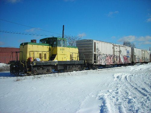 DCON GE switcher #9 bring two reefers from the facility at the end of their line up the old GTW toward Milwaukee Jct. 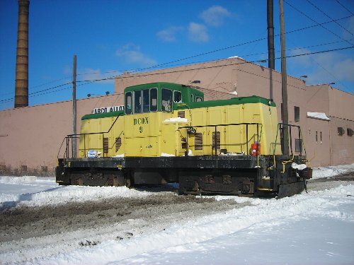 A roster shot of the DCON #9 on their line near Arco Alloys Corp. 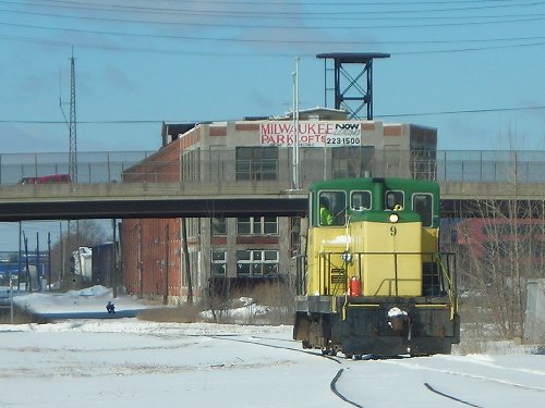 DCON #9 moves up their line toward the Boulevard and Milwaukee Jct. Renovated Milwaukee Park Lofts are in the background.  A closeup, cleaned up, and enhanced view of the small Rat Line insignia on the side of DCON #9. Thanks to M K for these photos of current DCON operations. |