Fareastsider Member Username: Fareastsider Post Number: 277 Registered: 08-2006 |
I was looking for a subdivision in Macomb and I came across an old plat of a town called Frankfort. I thought I knew all of the ghost towns in Macomb such as Belvidere or Milton. It appears to be along Hall Rd. Is this what was Waldenburg? It is where Waldenburg is/was. Anybody have any idea? There is a nice old map on the plat to it is from 1837 http://www.cis.state.mi.us/pla tmaps/dt_image.asp?BCC_SUBINDE X=8983 | ||
Mikeg Member Username: Mikeg Post Number: 736 Registered: 12-2005 |
Waldenburg was at 21 Mile and Romeo Plank Roads. This plat of "Frankfort" was on the north side of what is now Hall Rd. near Garfield and it appears to have straddled the section line between Sections 31 and 32. As you can see from this 1859 map, the plat was apparently never built, even though it had been recorded. | ||
Dougw Member Username: Dougw Post Number: 1636 Registered: 11-2003 |
Interesting. I've been to Frankfort, Michigan every summer since my birth, but that's the real Frankfort up in Benzie county, near Traverse City. That Frankfort is a fairly old town, apparently founded in 1850. It's kind of odd that this plat in Macomb county was around the same time. I guess if a town is never actually founded, another town can take the same name. | ||
Gtat44 Member Username: Gtat44 Post Number: 89 Registered: 02-2007 |
I would go to Frankfort every summer for a month in the summer. Worked in the Frankfort hardware owned by my aunt and uncle for one whole summer. Spent most of my time in a small town 12 miles south, Arcadia. My dad and grandmother still live in Arcadia to this day. | ||
Mikeg Member Username: Mikeg Post Number: 747 Registered: 12-2005 |
I would hazard to guess that the reason the settlement of Frankfort never came into being is that it was centered around the "extensive salt springs" at the Macomb Saltworks. While it would have been located close to the primary source of employment for its inhabitants, they would have had a tough time finding drinkable water, thus making it an impractical place to live in the 1840's. Here are two aerial photos (1952 and current), plus a topo map from the early 1970's, that show the proposed site of Frankfort. The dark overgrown area in the center of each image is the area where the salt springs were (are?) located along what is now called the Gloede Drain (a tributary of the Clinton River). I also need to make a correction, Waldenburg is located at 22 Mile Road and Romeo Plank, not 21 Mile Road. 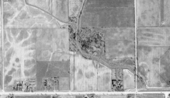 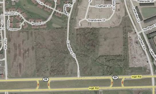 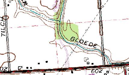 | ||
Fareastsider Member Username: Fareastsider Post Number: 286 Registered: 08-2006 |
I have seen a settlement called South Waldenburg at HAll and Romeo PLank before. I have even seen a map with a N Waldenburg at 23 Mile but I dont think that ever really existed. This link here the guy says that Romeo PLank and Hall has been called Waldenburg and that over the years different intersections in that area of Romeo PLank have been called such. I would have to say that this must have been the original settlement plan of what was to be Waldenburg or a halfway stop between Mt Clemens and Romeo. Though my favorite CDP name in Macomb has to be what was Disco at 24 and Van Dyke. http://mywebpages.comcast.net/ KB8GPO/waldenburg.html |