 
Islandman
Member
Username: Islandman
Post Number: 1830
Registered: 08-2004
| | Posted on Friday, January 16, 2009 - 2:11 pm: |    |
What's the one street in the Wayne State area with the "broken brick"? Tried to find it on Google. Has a cream color to the bricks. I think it's near the service drive (Lodge).
Go more than 5 miles an hour and you're going to shatter teeth. I think it's done purposefully.
Edit: Sorry, already been mentioned - W. Canfield
(Message edited by Islandman on January 16, 2009) |
Busterwmu
Member
Username: Busterwmu
Post Number: 475
Registered: 09-2004
| | Posted on Friday, January 16, 2009 - 5:01 pm: | |
Retroit, I'd also like to visit many of these spots, so thanks for keeping track with your list! The segment where the brick is peeking through the Asphalt at Vernor and Michigan is in the crosswalk along the north side of Michigan. You can see it if you zoom in on Google Maps.
I'll ask my friend to verify that Beaufait segment.
Add Woodbridge between Orleans and Dubois down on the riverfront east of the RenCen.
Did someone mention the stretch of Riopelle just below Gratiot and east of Russell?
There is also brick at the alley entryway off Carbon Street, just south of Dearborn St., in Delray, in front of the CSX Railroad Delray Interlocking Tower. |
Chuckjav
Member
Username: Chuckjav
Post Number: 1474
Registered: 09-2007
| | Posted on Friday, January 16, 2009 - 5:14 pm: | |
Busterwmu....pardon the brief thread-jack:
Are you employed as the Mascot for Western Michigan University.
If not....why not (with a name like yours)?
End of thread-jack |
Haikoont
Member
Username: Haikoont
Post Number: 77
Registered: 09-2008
| | Posted on Friday, January 16, 2009 - 5:52 pm: | |
Aren't all the streets of Bricktown brick? The proud Bricktonian people were known for their masonry. |
Busterwmu
Member
Username: Busterwmu
Post Number: 476
Registered: 09-2004
| | Posted on Friday, January 16, 2009 - 6:37 pm: | |
Chuck -
Nope, but I did attend WMU from 2003-2007, and received my degree in Public History. As you can see, I was in the midst of my freshman year when I needed a name for this web forum. Now I'm enrolled in the Masters of Historic Preservation program at EMU. But SwoopEMU just doesn't have the same effect. I was in the marching band while in Kalamazoo so we pretty much had to have school spirit whether we wanted to or not.
Interestingly, to make this related, while I was living in Kalamazoo, I did an informal survey of brick streets there. If anyone is interested, I can post it here.
Back to brick streets of Detroit, here's a photo I took in June of 2008 highlighting that 17th Street stretch and also the alley/service road, both brick.
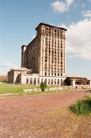
|
Chuckjav
Member
Username: Chuckjav
Post Number: 1476
Registered: 09-2007
| | Posted on Friday, January 16, 2009 - 6:49 pm: | |
Busterwmu....I'm not saying this, just because we are WMU-Bloodfolk:....that is a damn fine photograph - seriously! |
Retroit
Member
Username: Retroit
Post Number: 831
Registered: 04-2008
| | Posted on Friday, January 16, 2009 - 7:20 pm: | |
Busterwmu, I'd like to see that survey of Kalamazoo to see how they compare to Detroit.
Yes, I got Woodbridge (#2) and the Service Street (#3) off of Riopelle. As for Carbon Street, are you referring to the driveway approach about 50 feet South of Dearborn Street?
And, Haikoont, unfortunately not only are they not ALL brick, but none of them are brick at all. |
Busterwmu
Member
Username: Busterwmu
Post Number: 477
Registered: 09-2004
| | Posted on Friday, January 16, 2009 - 10:48 pm: | |
Wow, I didn't do a very good job reading the first list! Sorry to reiterate those again.
Yes, In regard to Carbon just south of Dearborn, the driveway/alley entrance perhaps 50 feet south of the intersection.
Here is what I have for a list of Kalamazoo brick streets:
Academy St.
From Monroe St. to 50ft west of Amtrak Crossing, and from 50ft east of Amtrak Crossing to 15ft west of Stadium Dr. Including intersections of Monroe, Bukley, Thompson, Acker, and Catherine.
Blakeslee St.
From Denner St. east to approx 350ft west of Douglas Ave. No intersections included.
Frank St.
From Burdick St. east to Harrison St.
Kalamazoo Ave. Alley (North)
From Walbridge St. west to 30ft east of Norfolk Southern wye track.
Monroe St.
From 50ft north of W. Michigan Ave. to Crawford St. No intersections included. Also at Academy St. in intersection and east on Academy.
Pioneer St.
From Oak St. east approx 300ft. Including intersection of Oak St.
Porter St.
From 60ft north of Norfolk Southern Crossing to Frank St. Including intersections of Frank and North. Not including intersection of Ransom St. or 25ft north or south of this intersection.
Ransom St.
From Rose St. east to 100ft west of Pitcher St. Including intersections of Rose and Edward. Not including intersection of Burdick.
Rose St.
From Ransom St. south to 80ft north of Amtrak Crossing. Including intersection of Ransom. Far right lane for northbound traffic is concrete.
Rose Parkway
From Rose St. west to end of street. Curbs and sidewalks are of new concrete.
Thompson St.
From Monroe St. to 15ft south of W. Main St. Including intersection of Monroe.
Walbridge St.
From Kalamazoo Ave. north to 100ft south of Norfolk Southern Crossing. Including intersection with Kalamazoo Ave. north alley. From Alley north to end of brick, center of road is asphalt. about 8ft wide.
Wheaton Ave.
From Short Rd. east to Merrill St. Including intersections of Short, Davis, and Merrill. |
Sumas
Member
Username: Sumas
Post Number: 577
Registered: 01-2008
| | Posted on Saturday, January 17, 2009 - 7:51 am: | |
My Dad said brick paved roads were too slippery when wet or snowy for cars, hence the switch to other mediums. Could be true but more likely it was a cost factor.
The roads in Eastern Market were brick covered in asphalt, I worked in the market for 4 years and you could see brick poking through where the asphalt was thinning.
Since you are into preservation, Marlborough, from Jefferson to Essex is brick because it supported a street rail spur into a prominant horsetrack. Essex was the end of the line. The city was going to cover it, but a woman in the area led the fight to save it as is. She died a few years back, Creekside Community Development Corporation wrote an obit for her in their newsletter detailing that fight.
A lot of the pavers for these roads came from Zanesville, Ohio. A kind of muddy brown color. I used to own a few. When we bought our first house we dug these up while gardening. They were used as border edges. So maybe some roads were dug up while others were merely coated over.
Good luck with your research. |
Living_in_the_d
Member
Username: Living_in_the_d
Post Number: 325
Registered: 01-2008
| | Posted on Saturday, January 17, 2009 - 1:23 pm: | |
Yeah, I put off this post as long as possible, but no one has mentioned the miles of alleys made of brick in Indian Village. |
Retroit
Member
Username: Retroit
Post Number: 834
Registered: 04-2008
| | Posted on Saturday, January 17, 2009 - 3:27 pm: | |
Thanks Busterwmu, looks like Kalamazoo fared a little better.
Good info, Sumas.
Great find, Living_in_the_d! No need to "put off":
17 & 18. Alley between Parker & Seminole and between Seminole and Iroquios: from Lafayette to St. Paul
19. Alleyway NW of & parallel to Jefferson between Parker and Seminole.
And while I'm at it, and since I've decided to conclude every bit of brick (why not?):
20. Alleyway approach off Concord just NW of Jefferson.
And, son-of-a-beech! It looks like they recently covered a brick alleyway with asphalt! Darn! (Alleyway NW of and parallel to Jefferson between Seyburn and Van Dyke - compare aerial to birds-eye in maps.live.com). They're still disappearing! |
Busterwmu
Member
Username: Busterwmu
Post Number: 478
Registered: 09-2004
| | Posted on Saturday, January 17, 2009 - 4:06 pm: | |
Chuck - glad you liked the picture. I saw the brick the one day and said there had to be a way to get MC and the brick in one cool photo. It looks 100 times better full size.
Retroit, some of those stretches in Kalamazoo are fairly short, but there are lots of exposed bricks around town! There are some additional places around Kalamazoo where I know the bricks just have a thin layer of Asphalt over them... South Street east of Michigan Ave. comes to mind for sure. And North Street at Stuart, too.
Back to Detroit:
If we're talking about alleys, I'm looking at an aerial of Cass Avenue, the alley on the east side, between Stimson and Peterboro. Sure looks like a part of that alley is brick, but I've never been there to verify for myself. |
Busterwmu
Member
Username: Busterwmu
Post Number: 480
Registered: 09-2004
| | Posted on Saturday, January 17, 2009 - 4:17 pm: | |
Chuck - glad you liked the picture. I saw the brick the one day and said there had to be a way to get MC and the brick in one cool photo. It looks 100 times better full size.
Retroit, some of those stretches in Kalamazoo are fairly short, but there are lots of exposed bricks around town! There are some additional places around Kalamazoo where I know the bricks just have a thin layer of Asphalt over them... South Street east of Michigan Ave. comes to mind for sure. And North Street at Stuart, too.
Back to Detroit:
If we're talking about alleys, I'm looking at an aerial of Cass Avenue, the alley on the east side, between Stimson and Peterboro. Sure looks like a part of that alley is brick, but I've never been there to verify for myself. |
Stromberg2
Member
Username: Stromberg2
Post Number: 160
Registered: 10-2006
| | Posted on Saturday, January 17, 2009 - 4:30 pm: | |
There is a brick alley behind the homes on Peterboro just west of Woodward, across from COTS.
Stromberg2 |
Busterwmu
Member
Username: Busterwmu
Post Number: 481
Registered: 09-2004
| | Posted on Saturday, January 17, 2009 - 4:35 pm: | |
Chuck - glad you liked the picture. I saw the brick the one day and said there had to be a way to get MC and the brick in one cool photo. It looks 100 times better full size.
Retroit, some of those stretches in Kalamazoo are fairly short, but there are lots of exposed bricks around town! There are some additional places around Kalamazoo where I know the bricks just have a thin layer of Asphalt over them... South Street east of Michigan Ave. comes to mind for sure. And North Street at Stuart, too.
Back to Detroit:
If we're talking about alleys, I'm looking at an aerial of Cass Avenue, the alley on the east side, between Stimson and Peterboro. Sure looks like a part of that alley is brick, but I've never been there to verify for myself. |
Stromberg2
Member
Username: Stromberg2
Post Number: 161
Registered: 10-2006
| | Posted on Saturday, January 17, 2009 - 4:36 pm: | |
There is a brick alley behind the homes on Peterboro just west of Woodward, across from COTS.
Stromberg2 |
Stromberg2
Member
Username: Stromberg2
Post Number: 162
Registered: 10-2006
| | Posted on Saturday, January 17, 2009 - 4:42 pm: | |
There is a brick alley behind the homes on Peterboro just west of Woodward, across from COTS.
Stromberg2 |
Retroit
Member
Username: Retroit
Post Number: 835
Registered: 04-2008
| | Posted on Saturday, January 17, 2009 - 5:22 pm: | |
You guys can say that again! 
Busterwmu, that sure looks brick to me, especially the birds-eye looking South:
21. Northern half of alleyway East of and parallel to Cass between Stimson and Peterboro.
22. Alleyway off of Peterboro between Woodward and Park Ave. |
Detroitsky
Member
Username: Detroitsky
Post Number: 12
Registered: 06-2007
| | Posted on Saturday, January 17, 2009 - 10:25 pm: | |
23. Morrow between Marston and Clay, near the Russell Industrial Center. |
Retroit
Member
Username: Retroit
Post Number: 836
Registered: 04-2008
| | Posted on Saturday, January 17, 2009 - 10:36 pm: | |
Thanks, Detroitsky, got it (#8)! |
Sumas
Member
Username: Sumas
Post Number: 578
Registered: 01-2008
| | Posted on Sunday, January 18, 2009 - 8:56 am: | |
There is a brick alley behind atckinson (north)near Boston Edison west of Woodward |
Tony_box_42
Member
Username: Tony_box_42
Post Number: 200
Registered: 12-2006
| | Posted on Sunday, January 18, 2009 - 9:38 am: | |
The parking lot at St.Joes'.Yellow brick.
Athena Brick Company. Ohio. I think it was part of a road . |
Retroit
Member
Username: Retroit
Post Number: 837
Registered: 04-2008
| | Posted on Sunday, January 18, 2009 - 2:29 pm: | |
23. Alleys between Atkinson and Edison and Woodward and 2nd.
24. Garfeild between Canfield and Forest & East of Russell, North of Sweeteast Heart of Mary (partial thanks to Tony_box_42. For some reason live.maps.com thinks that Sweetest Heart of Mary is St. Joseph).
Tony_box_42, are you talking about that lot off the end of Jay St. between St. Joseph's rectory(?) and the Dequinder Cut? |
Tony_box_42
Member
Username: Tony_box_42
Post Number: 198
Registered: 12-2006
| | Posted on Sunday, January 18, 2009 - 8:24 pm: | |
St. Joes',S.H.of Mary and St. Josephat are clustered. The mailing address is S.H.of Mary.
Could be the reason. That is the section I noticed.Parallel to Dequindre from Antietam to Jay. It may have through to Gratiot at one time. |
Townonenorth
Member
Username: Townonenorth
Post Number: 711
Registered: 10-2007
| | Posted on Sunday, January 18, 2009 - 8:48 pm: | |
A few years back, I noticed that on either Dubois or St. Aubin close by the service drive of 94, there were bricks showing through the asphalt, as well as what looked like a rail to a streetcar or trolley. I can't say for sure whether this is still there or not, it's covered up now. |
Retroit
Member
Username: Retroit
Post Number: 812
Registered: 04-2008
| | Posted on Sunday, January 18, 2009 - 10:18 pm: | |
Okay, that explains it. I wonder why those bricks are not the same color as all the other brick roads. Regardless...
25. St. Joseph driveway/parking lot: between Orleans and Dequinder Cut and from Jay 1/2 way to Antietam.
Townonenorth, this may not be what you're talking about because it's an alleyway, so it probably wouldn't have rails, but nevertheless...
26. Alleyway parallel to and East of Dubois between I-94 service drive and Medbury. |
Townonenorth
Member
Username: Townonenorth
Post Number: 712
Registered: 10-2007
| | Posted on Sunday, January 18, 2009 - 10:45 pm: | |
Not what I was talking about, but now that you mention it, I remember the alleyway you mentioned. There are others through the area, I'm sure. |
Chuck_g
Member
Username: Chuck_g
Post Number: 14
Registered: 01-2009
| | Posted on Monday, January 19, 2009 - 12:01 am: | |
I sure remember being sad seeing the brick street poorly repaired down at Michigan and Trumbel.
I remember too when they tore up Michigan Ave. in Dearborn in the 80s & removed the street car rails under the street. They paved over the rails, bricks, maybe other stuff. |
Busterwmu
Member
Username: Busterwmu
Post Number: 492
Registered: 09-2004
| | Posted on Sunday, February 01, 2009 - 5:11 pm: | |
Over the past couple days I've been thinking of other places to see Brick Streets in the city, and I just remembered another opportunity. Once the snow melts, you can see a couple different stretches of brick from an Amtrak train going west from Detroit Station. Through the section between the Amtrak station and CP-Vinewood (Near West Detroit Junction), there are a few service alleys which go up from Detroit streets to the track level raise above the landscape. Although they probably don't see much if any service, some are quite lengthy and are worth mentioning here. From Google maps, I can see the following:
Alley extending west from Lincoln St. along the GTW (near Trumbull)
Alley extending west from Commonwealth St. along the GTW
Alley extending south from Buchanan St. along the GTW (hard to tell if this is brick or asphalt)
There many be additional access alleys that can't be easily seen from the aerials (grown over/unused) that one may be able to pick out from the train.
Also, I verified that brick stretch on Beaufait just south of Mack on the east side, between the rails of a long abandoned industry rail spur. On the east side of Beaufait at the corner of Mack (southeast corner), there is a large warehouse or something with a black roof. Follow the street down to where this building ends. Just below that, along the east curb of the street, it looks like there are bricks between the rails. Again, something to be checked out on a day once the snow has melted more. |
Kellyroad
Member
Username: Kellyroad
Post Number: 1332
Registered: 04-2007
| | Posted on Monday, February 02, 2009 - 12:00 am: | |
Virginia Park (about 6 blocks north of the Fisher building) between 2nd and 3rd |
Busterwmu
Member
Username: Busterwmu
Post Number: 495
Registered: 09-2004
| | Posted on Monday, February 02, 2009 - 1:33 pm: | |
Here's a new one I found:
Perry St. between Wabash and 17th/W. Fisher Service Drive for something like 4 and a half blocks is brick. This is just north of I-75 more or less across from the Michigan Central station. Also looks like part or all of the alley going north from Perry between 14th and Wabash is brick, as is the alley entrence a block north on the north side of Temple between 15th and 16th. |
Gistok
Member
Username: Gistok
Post Number: 6099
Registered: 08-2004
| | Posted on Tuesday, February 03, 2009 - 12:15 am: | |
Lest we forget... The Streets Of Old Detroit in the Detroit Historical Museum! |
Busterwmu
Member
Username: Busterwmu
Post Number: 503
Registered: 09-2004
| | Posted on Saturday, February 14, 2009 - 4:14 pm: | |
Couple more I actually paid attention to while driving yesterday:
Eighth Street between Fort and Lafayette across from the main post office
Corner of Woodmere and Fort at the entrence to Woodmere Cemetary. |
Rsmack
Member
Username: Rsmack
Post Number: 1
Registered: 02-2009
| | Posted on Monday, February 16, 2009 - 3:36 pm: | |
Here are some alley bricks in Indian village. The are called Metropolitan Canton made from the red clay in Canton Ohio. This last summer I put Detroit alley bricks in front of Ye Olde Tap Room at Charlevoix and Alter. Looks great.
Indian Village Alley http://maps.google.com/maps?f=q&source=s_q&hl=en&geocode=&q=detroit&sll=37.0625,-95.677068&sspn=46.946584,87.1875&ie=UTF8&ll=42.356269,-82.994086&spn=0.001346,0.002661&z=19&layer=c&cbll=42.356307,-82.993985&panoid=sXYjd9TrOkimAooraCHRTw&cbp=12,338.46033598838465,,0,2.2649519907270843
(Message edited by Rsmack on February 16, 2009) |