Retroit Member Username: Retroit Post Number: 804 Registered: 04-2008 |
Does anyone know of a list/map of surviving brick roads in Detroit? If not, would anyone like to help make a list? I'll start: 1. Marlborough St. between Jefferson and Essex, I think one of Detroit's finest examples 2. Woodbridge St. between Orleans and Dubois 3. Alleyway East of and parallel to Gratiot near Historic Trinity Church 4. Michigan Avenue between Rosa Parks Blvd and the Lodge freeway, undoubtedly Detroit's most famous 5. 17th St. just NW of MCS 6. Standish St. between I-75 and 20th St. just SW of MCS I'd also appreciate any info/links related to the history of brick roads in Detroit. Thanks. | ||
6nois Member Username: 6nois Post Number: 785 Registered: 11-2006 |
Not brick but cobblestone, on Canfield between Second and Third. | ||
Detroitstar Member Username: Detroitstar Post Number: 1413 Registered: 01-2006 |
As much as I loved the cobblestone on Canfield, it is a real pain in the ass to drive...I actually take a longer route home so I dont have to deal with that. I could not imagine living there and having to drive on it every day. It looks great but it drives very poorly. | ||
Ptero Member Username: Ptero Post Number: 186 Registered: 12-2005 |
Strictly speaking, the cobblestone on Canfield is not surviving, except from the late 1970's/early 1980's when they put it in. It was also not split or one-way before then. Plain ol' concrete street. | ||
Novine Member Username: Novine Post Number: 1062 Registered: 07-2007 |
Sounds like a Google Maps project to mark the locations. | ||
Chuckjav Member Username: Chuckjav Post Number: 1454 Registered: 09-2007 |
Waterloo, westward from Chene Street, along the northern side of old Miller High School; terminates at Miller's athletic field. 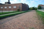 | ||
Philbo Member Username: Philbo Post Number: 81 Registered: 09-2008 |
Marston west of St.Aubin, at least it used to be. I have'nt been there in a while. (Message edited by philbo on January 15, 2009) | ||
Deteamster Member Username: Deteamster Post Number: 192 Registered: 07-2007 |
I am pretty sure Temple west of 16th is brick. There are a few others in Briggs. | ||
Retroit Member Username: Retroit Post Number: 805 Registered: 04-2008 |
8. Philbo, Marston has been repaved  ,but Marrow between Marston and Clay is still 1/2 brick. Thanks! ,but Marrow between Marston and Clay is still 1/2 brick. Thanks! 9. Deteamster, that would be Perry St. between I-75 and Wabash. Thanks! 10. Warsaw Pl. alleyway -West of St. Aubin between Hancock St. and Forest Ave. or 1 1/2 blocks SE of Warren. (Partial thanks to Philbo, or I probably wouldn't have found it!) A little Detroit road history: -Wood plank roads: Early 1800s -Cobblestone roads: Mid 1800s -Last cobblestone road: Franklin Road: Removed during building of RenCen -First concrete paved road: 1909: Woodward between 6 & 7 Mile -First asphalt paved road: 1919: Gratiot -Brick??? | ||
Detroitnerd Member Username: Detroitnerd Post Number: 3396 Registered: 07-2004 |
3. Alleyway East of and parallel to Gratiot near Historic Trinity Church (Isn't that Service Street?) | ||
Detroitnerd Member Username: Detroitnerd Post Number: 3397 Registered: 07-2004 |
11. Eighth Street between Fort and Lafayette. | ||
Detroitnerd Member Username: Detroitnerd Post Number: 3398 Registered: 07-2004 |
Detroit had cedar roads too. Look at some of the old maps from the 1910s and you'll see just how many different KINDS of roads there were. Though the brick was (and is) picturesque and durable, the hooves and wheels of the 19th century clattered less on cedar and wood roads. I think Forest at Second was cedar, because it was a toney neighborhood then. | ||
Hornwrecker Member Username: Hornwrecker Post Number: 1742 Registered: 04-2005 |
Many of the city streets were paved with cedar blocks, rather than wood planks. The cedar trunks were cut to length and layed on end, either as cylinders or squared off. I believe some of them lasted into the 20th century. | ||
Retroit Member Username: Retroit Post Number: 808 Registered: 04-2008 |
3. Detroitnerd, yes, sorry for the downgrade!  | ||
Gnome Member Username: Gnome Post Number: 2254 Registered: 08-2007 |
Silas Farmer wrote about the construction of roads dating back to the early days. http://books.google.com/books? id=2dtMHBxD6R8C&pg=PA925&dq=pl ank+roads+detroit it is an extensive read | ||
Retroit Member Username: Retroit Post Number: 809 Registered: 04-2008 |
No mention by Silas of brick roads...hmmm... he did mention brick sidewalks, though (p.930). Maybe they were a post-1884 innovation. | ||
Busterwmu Member Username: Busterwmu Post Number: 472 Registered: 09-2004 |
Add Gould St. between Crossley and Anderson in Delray to the list. In addition to 17th next to the MC railroad station, there is an alley or narrower side street on the west side of 17th, just south of Rose. It kind of goes off into the weeds, but I think it was once a service road to the old MC RR coach yards there. In that same neighborhood, but on the south side of the tracks, add Standish between 20th and 22nd/Jefferies Service Drive, and 21St between Standish and W. Vernor. This is a great thread... when I think of more, I'll add them! | ||
Retroit Member Username: Retroit Post Number: 816 Registered: 04-2008 |
That's 12, 5b. and 6b on the list I'll take your word on 21st off Standish. From the aerials it looks like asphalt. It must be covered with a lot of dirt. Does anyone know if bricks still exist under any roads, or were they all taken out before concrete/asphalt paving? I wonder if it would be possible to restore any to brick? | ||
Fho Member Username: Fho Post Number: 50 Registered: 11-2003 |
Woodward just north of Grand Circus Park. At least I think that's brick. | ||
Goirish1966 Member Username: Goirish1966 Post Number: 50 Registered: 02-2007 |
Are any of these roads yellow? | ||
Retroit Member Username: Retroit Post Number: 818 Registered: 04-2008 |
Fho, I think that's recent. Maybe someone can confirm when that was done. It's from Elizabeth to Montcalm, in front of the Fox. Goirish1966, if you were not being facetious, the answer is no. I'm not to good with my colors, but I'd say they are a darkish-reddish-with-a-hint-of-purplish color. Which brings up another question. I've heard that the bricks on the older homes and buildings of Detroit, which are a light orangish-rosish color (after they are cleaned of the century or more of grime) were made from clay from the Detroit River. So I wonder why these brick roads are so much redder. Anyone know? Edit: color description (Message edited by Retroit on January 16, 2009) | ||
Detroitgalaxian Member Username: Detroitgalaxian Post Number: 21 Registered: 06-2006 |
Wight St., between Mt. Elliot and Iron St. This short stretch even includes old tracks in the road. | ||
Retroit Member Username: Retroit Post Number: 819 Registered: 04-2008 |
That's another one that's hard to tell from the aerials, except the Southwestern end. I wonder if we should start another thread on roads with existing railroad tracks? This might be tricky because they are obviously beneath a lot of roads but not visible themselves...hmmm... | ||
Busterwmu Member Username: Busterwmu Post Number: 474 Registered: 09-2004 |
I don't think anyone has yet mentioned that some areas in the parking lane (curblane) along Woodward near Mid-town and Lafayette near downtown are brick, though I'm not entirely sure why they are this way. Seems strange they would want to have two different pavement forms stretched out like that. Anyone know why? I remember 21st being Brick north of Vernor, but the bricks were more brown than orange-red, so it may not look like pavers on the aerial. Also, I've heard that there is a stretch of Beaufait on the east side just west of E. Grand that has a railroad track running down the center, and it is brick in between the rails. Can't see that on the map, though. As for rails under the pavement, Michigan Ave. between Wyoming and Livernois had all streetcar rails removed when they rebuilt it a couple years back. The rails are still in place on the brick stretch farther toward downtown, however. I remember you could see a curving rail poking through the pavement at Junction and Vernor, and Junction and Fort. Don't know with repavings, etc, if they are still visible, though. How about Hubbard on the west side, just north and south of Michigan Avenue, near the Clark grade separation? Looks like small sections of exposed brick there. As to places where asphalt covers brick, there are plenty. As I recall, one place in particular you can see it is at Michigan Ave and Vernor in front of MCS, on the north side of the intersection. | ||
Retroit Member Username: Retroit Post Number: 825 Registered: 04-2008 |
For my own sanity, I'd like to number these, so that when the weather clears, I can get a first-hand look. 13. Wight: Mt. Elliot to Iron 14. Beaufait?: Jefferson to Charlevois?: Center only 15. Hubbard: approaches off of Michigan 16. Vernor: small patch North of intersection with Michigan | ||
Lodgedodger Member Username: Lodgedodger Post Number: 1365 Registered: 05-2008 |
Retroit, great thread. | ||
Retroit Member Username: Retroit Post Number: 826 Registered: 04-2008 |
^Appreciating Detroit, one brick at a time! | ||
Ongowwah Member Username: Ongowwah Post Number: 173 Registered: 03-2008 |
Whether you appreciate driving on them or not, they sure hold up better than the putty that passes for roadways today. I rather replace a broken brick or two than entire stretches of asphalt. Do we have any concrete or asphalt streets that are 100 plus years old? | ||
Retroit Member Username: Retroit Post Number: 828 Registered: 04-2008 |
Yeah, it makes me wonder why they weren't kept. I can see that maybe on main thoroughfares, the "texture" may be too rough for long periods of time; but for side streets / residential streets, it seems ideal. | ||
Ongowwah Member Username: Ongowwah Post Number: 175 Registered: 03-2008 |
yeah, and maybe it would slow down some of the residential speeders! |