Douglasm Member Username: Douglasm Post Number: 886 Registered: 10-2003 |
I'm not really sure if it's germaine to the discussion, and I really don't clearly remember how much industry there was between Milwaukee Junction and Brush Street, but my rememberance tells me that the primary reason for rail between the Junction and downtown was to service Robin Hood flour, the GTW/CN carferry, and Brush Street Station. Take away the ferry and the flour mill, and it probably wasn't really worth maintaining the tracks for what ended up being 2 trains a day each way. As to Fishtoe's comment about a turntable, I don't know why there would be one. The GP-9's used in commuter service were bi-directional (generally run long hood forward), and the coaches probably didn't care which way they ran. I know the old commuter coaches had "walkover" seats, and if they ended up using unemployed inter-city coaches, the seats swiveled so they could be turned around. Also, after the Milwaukee Junction roundhouse was leveled I believe the only turntable between Detroit and Durand was in Pontiac. Fellow I know put a diesel either into the pit or through the back wall up there..... | ||
Quinn Member Username: Quinn Post Number: 1415 Registered: 01-2005 |
I can't imagine a turntable being used for a commuter train either. I imagine the turntable was for a streetcar...still pretty cool. | ||
Rsa Member Username: Rsa Post Number: 1181 Registered: 10-2003 |
i have heard that the joe louis arena parking structure was reinforced so that trains could pull up into it. the idea was that the parking structure and commuter station would be integrated. supposedly, it was constructed assuming the rest of the funding for the station and lines would be installed afterwards. i also seem to remember the old union station having something to do with that; they built it as a substitution for it, utilized funding from it, or something. maybe somebody remembers? | ||
Pete Member Username: Pete Post Number: 86 Registered: 10-2003 |
rsa, i thought that i had heard that as well about trains actually being able to pull into the parking structure. so, that's probably what the mayor was referring to when he told me that the new commuter line could possibly utilize the joe louis parking structure with a nice tie-in to the people mover. although those pedestrian tunnels really aren't user-friendly. and a downtown station there would not be any part of the pilot project that currently being discussed - it could probably happen if the line became permanent. | ||
Rsa Member Username: Rsa Post Number: 1182 Registered: 10-2003 |
I imagine that could be a supplemental project, pete. this could be the western commuter station, while the one we're discussing above could service the northern and eastern portions of the city. on a grand scale, you could incorporate that with a redesign/expansion of the pedestrian tunnels, the expansion of cobo's loading dock, and/or any expansion to cobo that might replace joe louis arena. so, hypothetically, you could tie metro airport directly to cobo and make it look really sharp. [ps. thanx for bringing that up. that was planned to be a mirror image of the ren cen station.] | ||
Professorscott Member Username: Professorscott Post Number: 558 Registered: 12-2006 |
Was it ever suggested how trains would get from the existing tracks to JLA? Anyone have a map or such a thing? | ||
Hornwrecker Member Username: Hornwrecker Post Number: 1844 Registered: 04-2005 |
 wsu/vmc I answered the turntable thing in post #1843, they're from the turn of the last century, long abandoned. GTW and LS&MS also went down to the river, because there were also RR ferries crossing the river there, as well as all the industry. I'll have to dig around in my files to find the map. | ||
Professorscott Member Username: Professorscott Post Number: 559 Registered: 12-2006 |
But today, so far as I can tell from maps, there aren't any tracks east of where the trains enter the river tunnel. Or am I wrong? Incidentally where are the tracks in the above photograph? | ||
Transitrider Member Username: Transitrider Post Number: 15 Registered: 01-2007 |
Prof, I believe it would have been following the diagonal from Michigan Central to Jefferson near 10th, then parallel to Jefferson to the JLA parking structure: http://www.gmap-pedometer.com/ ?r=1167708 See also the Appendix C, section C.4, pp. 16-19 http://www.annarbordetroitrapi dtransitstudy.com/news/pdfs/ap pendix_c.pdf for specifics about a JLA alignment. | ||
Jsmyers Member Username: Jsmyers Post Number: 1905 Registered: 12-2003 |
A lot of the more recent questions in this thread can be answered by the link that Transitrider posted at noon today: http://www.annarbordetroitrapi dtransitstudy.com/news/pdfs/ap pendix_c.pdf The Joe Station, although a decent idea, was also eliminated from consideration. With regards to New Center, the current Amtrak station is temporary in many regards. http://maps.google.com/maps?f= q&hl=en&geocode=&q=detroit&ie= UTF8&ll=42.367034,-83.071575&s pn=0.002751,0.006781&t=h&z=18& om=1 The block of land on the south of the tracks, bounded by Woodward, Amsterdam, Cass, and the railroad is owned by the state of michigan for the purpose of building a more substantial and permanent train station for Amtrak and Commuter traffic. IMHO, this is a decent idea, but the long term goal should be to build a station at MCS. It would have to be at least part new construction, even if the old dino is restored. This location has a few big plusses (I'm thinking mostly in terms of intercity traffic.): -It is closer to points west and south, shortening train travel time. -It is very easily accessible to trains from Canada, right now there are 4 VIA arrivals and departures in Winsor, but no reasonable way to transfer to/from Amtrak. -It is big enough to service a number of trains. -It is closer to downtown. -We have to do something with that land. I do think that even if something is eventually done at MCS, the new center location is great for a commuter rail stop. I'll put another plug in for transit activities this week. See: http://www.detroittransit.org/ meetings.php -Today at 6:30 is the TRU meeting -Tomorrow, Thursday, and Saturday are official transit study meetings. -Friday is a open house of the Regional Transit Coordinating Council | ||
Jsmyers Member Username: Jsmyers Post Number: 1906 Registered: 12-2003 |
Sorry Transitrider, I was composing my post when you answered their questions. I don't stop by here too much, but when I do, I try to make it worth it. Good luck this week with everything. | ||
Livernoisyard Member Username: Livernoisyard Post Number: 3484 Registered: 10-2004 |
It's obvious that Scott never walked the moat. There's still a very tiny bit of track left (for some reason or another), which can be barely seen from the Twelfth Street bridge. [Kids: Don't do that at home because the Border Patrol cops might nab you these days. They park their squad car near the tunnel.] There used to be tracks connecting to the MC's older Third Street station. It burned down in 1912, and they used their newer depot after that. And yes, it connected between Tenth and Eleventh street, by Jefferson. The Canadian trains using the tunnel had to do an unusual backup maneuver in order to get to the Third Street station before 1913. | ||
Rsa Member Username: Rsa Post Number: 1183 Registered: 10-2003 |
thanx myers and transitrider; that's very informative. correct me if i'm wrong, but doesn't that study say that it would be relatively easy to have it terminate into the joe louis arena parking garage? the main point they're making is that it would be extremely difficult to put a terminus EAST of the parking structure (between joe louis and the ren cen)? | ||
Hornwrecker Member Username: Hornwrecker Post Number: 1845 Registered: 04-2005 |
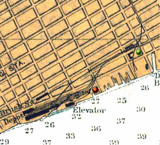 The red dot is where the LS&MS turnable was, and the green was where the former GTW one was, right next to the Detroit Dry Dock & Shipbuilding/Globe is. From a 1904 nautical chart. | ||
Jsmyers Member Username: Jsmyers Post Number: 1907 Registered: 12-2003 |
Rsa, From my reading, Yes, except that they decided (for whatever reason) that it needed to go further. IMO this is a result of very rigid study objectives. I haven't heard too much positive about that study, and as somebody in the field, I can't say I disagree. | ||
Mike_m Moderator Username: Mike_m Post Number: 8 Registered: 09-2006 |
Rivard & Atwater 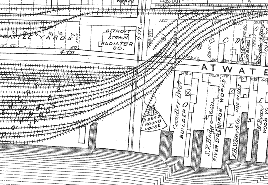 | ||
Detroit_stylin Member Username: Detroit_stylin Post Number: 4447 Registered: 10-2003 |
Mike approximately what year does that map represent? | ||
Mikem Member Username: Mikem Post Number: 3397 Registered: 10-2003 |
1885 | ||
Transitrider Member Username: Transitrider Post Number: 16 Registered: 01-2007 |
Rsa: Yes, which is fine. (Although Cobo reconstruction might give us more options.) | ||
Ndavies Member Username: Ndavies Post Number: 2706 Registered: 10-2003 |
We'll also get some added options if Ilitch builds a new stadium in Foxtown. | ||
Hornwrecker Member Username: Hornwrecker Post Number: 1848 Registered: 04-2005 |
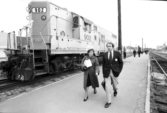 wsu/vmc SEMTA Geep, (probably) at Ren Cen Sta. | ||
Jerome81 Member Username: Jerome81 Post Number: 1588 Registered: 11-2003 |
There used to be a ren-cen train station??!! When was this? Where did the train come from? Was there once midtown (current), MCS, AND Ren Cen? And it was commuter rail? | ||
Burnsie Member Username: Burnsie Post Number: 1089 Registered: 11-2003 |
Jerome81-- In 1866 a 2-story brick terminal was built at the foot of Brush St., roughly where the RenCen hotel is now. It replaced a structure that had been destroyed by fire. In the early years Brush St. also served Lake Shore & Michigan Southern trains and perhaps Wabash, too. GTW intercity trains went from Brush St. to Chicago via Durand. They also went from Brush St. to Port Huron, via Mount Clemens. At Durand one could also ride all the way to Montreal and Halifax. You could also get on a passenger car at Brush St. and ride across on CN/GTW carferries to Windsor, connecting with trains there. The line to Pontiac was completed in 1843. In 1838 its first section, to Royal Oak, had been completed. In the very early years, the line swung south on Gratiot and ended somewhere near Farmer St., IIRC. GTW commuter trains went from Brush St. to Pontiac. SEMTA took them over, effective Dec. 19, 1973. The old Brush St. station served both intercity and commuter Grand Trunk trains until May 1, 1971 (Amtrak startup date). After that date, it served commuter trains only. Soon Ford Land released its Ren Cen plans. GTW closed the Brush St. station on June 29, 1973 and Ford Land immediately tore it down. The RR line was shortened to end about 2 blocks upriver, and a tiny prefab station for commuter trains was set up. This station eventually relocated to the end of a parallel former industrial spur immediately to the north, near the corner of Franklin and St. Antoine. GTW/CN carferries from near the RenCen site continued running until Feb. 20, 1975, when GTW began utilizing new trackage rights through Penn Central's tunnel. The prefab commuter station closed on Oct. 17, 1983 when the trains were discontinued. I think it sat there for many years thereafter. In the mid to late '90s, an enormous parking ramp was built where the commuter trains used to stop. Freight service to the riverfront ended circa early 1997 when GTW stopped serving Lafarge Cement. The boxcars in the pic from WSU that Hornwrecker posted likely were for the Detroit News warehouse. It was adjacent to the 2nd location of the prefab commuter station. | ||
Burnsie Member Username: Burnsie Post Number: 1090 Registered: 11-2003 |
Forgot to answer Jerome81's other question: Yes, at one time Brush St., the MC Depot, and the New Center all had functioning RR passenger stations. But the New Center stop was for the NYC system. It was a tiny structure and on the site of or across the tracks from the current Amtrak station; I think Virtual Motor City has a scan. This small NYC station did not function as NYC's main station; the MC Depot did. Amtrak's station didn't open until spring 1994, when it vacated the prefab Rose St. station it had occupied since Jan. 1988, after moving out of the MC Depot. An interesting summary from the Surface Transportation Board's decision to allow GTW to abandon the Dequindre Line: "In its petition, GTW states that no rail service has been provided on the line since April 1997. GTW indicates that, until March 27, 1997, it provided rail service to Lafarge Corporation (Lafarge), which is located on a spur at milepost 0.71. GTW claims that it handled 93 carloads of cement for Lafarge in 1996 and 66 carloads in the first 3 months of 1997 and realized revenues of $53,143 and $35,010, respectively. GTW states that it has not moved any traffic for Lafarge or any other shippers on the line since April 1997 and that no other active shippers are situated nearby. GTW indicates that Lafarge no longer requires rail service and will not oppose abandonment of the line.(4) "GTW asserts further that there is no possibility that a new shipper could locate on or near the line. It notes that the physical characteristics of the right-of-way make it almost impossible to locate a business there.(5) GTW further states that the City has initiated condemnation proceedings to acquire all of the land the City does not own or control in the area of redevelopment, except for the land underlying the line. "GTW states that it receives no freight revenues to justify the costs of rehabilitation and maintenance and that there is no reasonable prospect that enough traffic and revenues will return to the line to warrant keeping the line in operation. According to GTW, the line is currently classified at Federal Railroad Administration Class 1 condition. To maintain that status, GTW says that it would need to spend at least $12,000 to repair trackage. In addition, GTW says that it is responsible for half of the cost of maintaining the 10 city-owned, overhead bridges on the line at an estimated cost of $1,127,500 over the next 10 years. GTW maintains that abandoning the line would enable it to avoid these costs and reallocate its resources to other lines in its system. "GTW states that, after abandonment, it will transfer the underlying property to Jefferson Holdings, LLC (Jefferson), a company composed of the developers of the project. According to GTW, Jefferson and/or the City expect to use the right-of-way for a transportation corridor. Current plans are to construct a four-lane roadway over the right-of-way to provide access from highways and streets into the project area. GTW indicates further that the City has reserved the right to use the right-of-way for mass transit." | ||
Douglasm Member Username: Douglasm Post Number: 888 Registered: 10-2003 |
Burnsie..... .....I'm gonna show my out of townism here. Where was the NYC New Center station site? GTW also served the New Center area with a depot at Milwaukee Junction where commuters could connect via DSR busses to the GM and Fisher buildings. It was on the southeast corner of the diamond. | ||
Burnsie Member Username: Burnsie Post Number: 1091 Registered: 11-2003 |
Douglasm, it was where Woodward crosses under the tracks at Baltimore-- on or very close to the current Amtrak station site. | ||
Jsmyers Member Username: Jsmyers Post Number: 1908 Registered: 12-2003 |
quote: Interested forumers might want to review the 4 pages of hall of fame thread on the subject of train stations in the city: https://www.atdetroit.net/forum/mes sages/6790/54651.html?11750992 66 | ||
Jasoncw Member Username: Jasoncw Post Number: 400 Registered: 07-2005 |
About the Joe Louis train station, recall that the original intent of the people mover was a downtown distribution center. The idea was for things to be connected at the edge of the loop, where you would either get off to downtown, or use the people mover to quickly, and simply transfer to another line. This is also why the people mover takes the strange, long path around cobo. The train station in New Center is really lame, and the plans for the replacement aren't much better. Here's what I think would be really cool: http://img504.imageshack.us/im g504/2628/newcenterstationai0. jpg Blue: Hotel or office Red: residential or office peach: residential or office (shorter than the other chunk) Brown: Parking, with patios and stuff on top White: Enclosed platforms. There could also be shallow ground floor retail, with a department store in the deeper parts, and with the second floor also being the department store. Or a mall type thing could go there. The parking structure would be really big, and would serve New Center, tech town, the occupants of the new train station, and the commuters using it. | ||
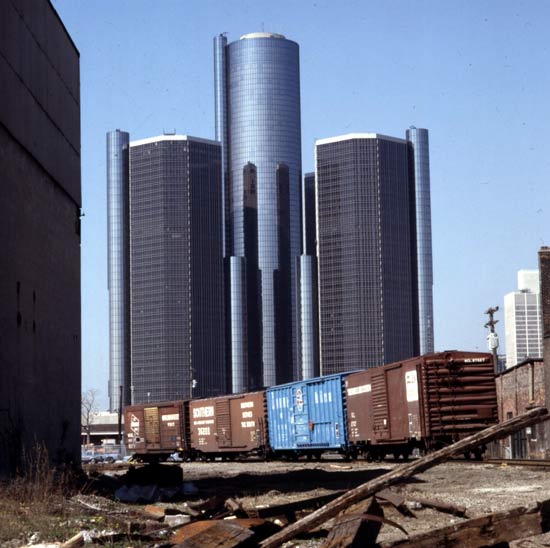
Neilr Member Username: Neilr Post Number: 545 Registered: 06-2005 |
Rsa, that photo was used by MOMA as the poster for their Transformations in Modern Architecture show in 1979. It is my favorite Detroit poster. 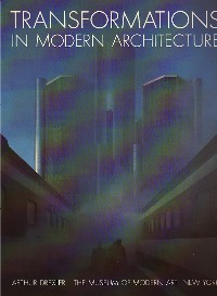 | ||
Hornwrecker Member Username: Hornwrecker Post Number: 1849 Registered: 04-2005 |
There's a similar pic at the Virtual Motor City, in a large size. The sky needs a bit of work to fix. There's a few more color shots, search for SEMTA.  |