 
Gistok
Member
Username: Gistok
Post Number: 4223
Registered: 08-2004
| | Posted on Saturday, April 28, 2007 - 10:12 pm: |    |
And for those inquiring about Chris Mazzola, ask if her mother Helen Mazzola is still alive. I used to work with Helen at Chatham #8 on Morang & Kelley, and I always liked her. |
Kville
Member
Username: Kville
Post Number: 7
Registered: 04-2007
| | Posted on Monday, April 30, 2007 - 4:17 am: | |
Interesting to read about all the people who went to Vetere's. My dad had a hardware store on Mack near 7 Mile and the Vetere brothers were friends of his. Derone (sp?) on Morang and Bidigare's on Kelly were friendly competitors. It seemed everyone in my family lived in the neighborhood, which as far as I can recall, never had a name. The only name I recall for our neighborhood was sometimes 7-Gratiot, although where we lived on Laing, we rarely had to go as far as 7-Gratiot to shop - everything was closer on Kelly, Morang, Whittier. I lived on Laing from 1949-67 and some years later on Elmdale & Dickerson during the late 70's, early 80's.
Anyone remember Ross's Drug Store on Morang & Whitehill where we spent lots of time buying penny candy (which actually cost a penny at that time)? Or Joe's Tick-Tock Market almost next door? Joe was the nicest guy. I remember that right after my grandmother died (he used to deliver to her house on Moross & Rossiter), I had to go the his market for something & he asked about her because he knew she had been sick. When I told him that she had just died the day before, he made a point to come to the funeral. I'll never forget him. |
Kellyroad
Member
Username: Kellyroad
Post Number: 16
Registered: 04-2007
| | Posted on Thursday, May 03, 2007 - 11:47 pm: | |
Kville
Thanks for jogging my memory. Didn't do a lot of shopping on Morang (lived closer to Moross and Kelly) but I do remember passing Joe's Tick-Tock Market. What was the name of the optician on Morang between Payton and Riad? Does anybody remember Henny Penny (chicken and fish take out on the corner of Riad and Morang? |
Gistok
Member
Username: Gistok
Post Number: 4240
Registered: 08-2004
| | Posted on Friday, May 04, 2007 - 1:05 am: | |
Wasn't there a Chinese Restaurant there too? And a Mr. C's. My buddy lived down Riad, which dead ends at a playfield.
And wasn't there a scuba diving place on the other side of Morang? |
Kville
Member
Username: Kville
Post Number: 20
Registered: 04-2007
| | Posted on Friday, May 04, 2007 - 4:28 am: | |
I think the Chinese restaurant was named Pagoda, but not sure. Mr. C's came later - it had been a party store before named Party Den. Also Krupa's (grocery store) on Morang & Riad (formerly Nino's) and every other store you can think of in those blocks near Kelly. |
Eastsidedame
Member
Username: Eastsidedame
Post Number: 123
Registered: 12-2006
| | Posted on Tuesday, May 08, 2007 - 11:54 pm: | |
Eastsiders:
Do any of you or those close to you remember I-94 being built? What effect did it have on you or your family. Did your neighborhood get torn up?
I remember it going as far as 8-Mile road for the longest time. My backyard faced the service drive, and that's how I learned makes and models of cars.
There's another thread ongoing asking about which expressway did the most damage in being built, and which least affected the neighborhoods.
Either go to https://www.atdetroit.net/forum/mes sages/5/100745.html?1178681974
or express your opinion here. There's someone who says they're an east sider, yet believes I-94 did THE LEAST DAMAGE to the area! Unbelievable! |
Kville
Member
Username: Kville
Post Number: 26
Registered: 04-2007
| | Posted on Wednesday, May 09, 2007 - 4:18 am: | |
I remember I94 being built. I recall that for a while it only went as far as Livernois and then worked its way east in the subsequent years in late 50's - no Lodge or Chrysler interchanges yet. It went to Conner for a while and then when it got out to 8 Mile, one of the big questions was always about why the expressway surfaced east of Conner (I later discovered that it goes over Conner Creek there). It totally isolated that little pocket of homes east of Conner & just west of Chandler Park.
Out in Harper Woods, there used to be businesses on the west side of Harper (officially the north side of Harper, even though Harper runs N/S out there). They were all torn down, including some restaurants we used to go to as a kid.
We lived about a mile west (north) of I94 near Kelly & Morang and my parents had a business near Mack & 7 Mile, so we had to cross it every day. In my experience out in our neighborhood, there were enough bridges crossing it that it didn't seem to isolate our areas as it did farther into the city. We could still cross at Moross, Morang, Cadieux, Whittier. Harper Woods was a little more of a challenge because there was really only one car overpass between 7 & 8 Mile. |
Kellyroad
Member
Username: Kellyroad
Post Number: 17
Registered: 04-2007
| | Posted on Wednesday, May 09, 2007 - 10:47 am: | |
I do remember the "ditch" at 1-94 and Moross. There were a few homes moved from the Harper/Morang area north to 7 mile east The sight of homes on trailers moving slowly up Morang was awe inspiring to a little kid. Our family lived in Detroit(Kelly and Moross) but since we were so close to Harper Woods we did most of our shopping there along Kelly. It seemed that Harper Woods were two different cities because of I-94 especially (as Kville pointed) there were not many crossings between Moross and Vernier. I'm not sure of how many other cities were impacted as much as Harper Woods (for better or worse). Yes, there were many communities in Detroit that were simply wiped out or displaced because of the Federal Highway project. It was said in a newspaper article that Hudson's created their own demise (of downtown Hudson's)when Joseph Hudson strong armed the freeway planners to swing the lodge near Northland. Yes, it is interesting to speculate what Detroit would be like today if the major expressways did not thread through the downtown area. |
Kellyroad
Member
Username: Kellyroad
Post Number: 18
Registered: 04-2007
| | Posted on Wednesday, May 09, 2007 - 11:17 am: | |
Sense of direction: Ok all you eastsiders, What was the "feel" of direction of some of the major streets on the eastside that ran diagonally What was popularly considered east-west had more of a north-south feel, especially if the street intersected with another diagonal street. Examples: I felt I-94 ran north south because it crossed Moross which had more of an east-west feel. Cadieux felt more as an east-west street. Morang felt north south but that is tricky because it bisects Kelly which also had a north south feel (Yes, I realize that Morang curves but it still had that north-south feel. And strangely enough Jefferson or Lakeside Drive had a north-south feel because of how other diagonal streets bisected or ended there especially at the end of Moross or Vernier. Harper had a north-south feel. Even Mack because of how it bisects Moross had somewhat of a north-south feel. I know when you look at a map that does not make sense. WHAT IS YOUR SENSE OF DIRECTION? |
Kathleen
Member
Username: Kathleen
Post Number: 2259
Registered: 10-2003
| | Posted on Wednesday, May 09, 2007 - 11:38 am: | |
Growing up near Warren-Outer Drive, I always felt like Mack, Warren, Chandler Park Dr., Harper, I-94 were east-west, and Outer Dr./Whittier, Cadieux/Morang, Moross, etc. were north-south. |
Gistok
Member
Username: Gistok
Post Number: 4279
Registered: 08-2004
| | Posted on Wednesday, May 09, 2007 - 12:17 pm: | |
Eastsidedame, I tend to think that except for the removal of the houses for I-94, that adding that freeway IN NO WAY ruined the area. In fact most of the folks living on the far east side were pleased as punch that they now only had a 15 minute commute downtown (or elsewhere), where before it took 45 minutes or longer.
How is that ruining the area??
No businesses took flight because of it (that happened later starting in the 1990's with white flight and the states removal of residency requirements). The business district has taken a downturn only since the 1990's, and not since the 1960's when the Freeway went thru.
And as has been already mentioned, displaced houses were not torn down, but were moved. I remember in 1960 on my street (Marseilles) seeing a house coming down our street from the freeway moving down the street to an empty (i.e. infill) lot. |
Eastsidedame
Member
Username: Eastsidedame
Post Number: 124
Registered: 12-2006
| | Posted on Wednesday, May 09, 2007 - 3:50 pm: | |
Sounds like some of you may want to go and talk to your parents and/or grandparents about this issue. You'll get an interesting lesson in Detroit history, I'll wager.
Just one example: What about San Francesco Catholic Church? That was THE hub of east side Italian-American spirituality in the first half of the 20th Century. Throughout my childhood, I was told stories of police dragging old people out of their homes and people only being paid a small fraction of what their property and businesses were worth. Eminent domain, indeed!
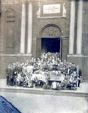
Of course, it didn't affect me, as a person...I was a KID! Unless they tore down KayCee's, Marquette or the Top Hat (the car-hop place in front of the East Side Drive-In), I was fine with just about anything. I just gotta stand by my contention that the building of I-94 was anything but a nightmare for those who lived in the old Polish, Italian and Black communities it uprooted. Below is my (biological) maternal grandfather's funeral in front of San Francesco's in 1925. The church was built in 1898.
|
Gistok
Member
Username: Gistok
Post Number: 4281
Registered: 08-2004
| | Posted on Wednesday, May 09, 2007 - 4:13 pm: | |
Eastsidedame,
Go look at the DetroitYes Hall of Fame thread on "DETROIT EXPRESSWAY PLANNING CIRCA 1945".
There you will see the plans that were developed over a decade before actual demolition. Now yes there are many horror stories about folks being dragged from their homes, ditto for Poletown.
But on the far east side where you and I both lived, most homes weren't built until the late 40's or early 50's. So the location of the Freeway was already planned, and homes weren't built in the proposed path of the freeways.
Now farther into Detroit it was a different story, where pre-WWII housing and buildings were built.
But not on the far east side. And that is all I was referring to, and also that is all that URBANIZE was referring to when you blasted him in another thread.
One of the other threads on streetcar lines only shows the streetcars going as far as Harper and Morang, where a turntable turned the streetcars around because there wasn't much beyond that point.
So when you ask how horrible it was... it was only that way for the folks who actually lived in the path, or in your case where a cherished church was in the way.
So your family experienced grief over the freeway expansion, while many others didn't. So there's really nothing to argue about. It affected some folks (and communities), and not others. |
Kville
Member
Username: Kville
Post Number: 32
Registered: 04-2007
| | Posted on Thursday, May 10, 2007 - 4:58 am: | |
Kellyroad - I grew up in same area as you and directions were definitely a challenge. You said you thought Morang had a n/s feel, even though it crossed Kelly, which also had n/s feel. Actually, since Morang ran exactly parallel to Moross, which was more of an e/w street, I always thought of it as an e/w street. Cadieux, on the other hand, even though it seemed also to be almost parallel to Morang, actually ran parallel to other n/s streets, including all the "English" streets (Kensington, Grayton, Yorkshire, etc.). Whittier, however, above Harper ran more e/w and when it crossed Harper, ran more n/s.
Another neighborhood I lived in at Dickerson & Elmdale was a nightmare to non-natives. If you look at a map, you can see that there are about 4 or 5 different street patterns converging in that neighborhood, depending on whether you were east or west of Chalmers, north or south of Houston-Whittier, or in the area east of City Airport west of Gratiot. And then there was Outer Drive & Gratiot which provided additional challenges of their own. It seemed that every street pattern that exists in Detroit somehow met in that neighborhood and many of the streets had to correct themselves in order to synthesize directions. No one could find their way around that area unless you had lived there a long time.
I used to have a friend on the west side who went nuts trying to talk to me about direction. When I told him he needed to go north on I94 or Harper, he said "That's impossible - I94 goes east & west." Obviously, he had never been to the east side. |
Lmr
Member
Username: Lmr
Post Number: 25
Registered: 03-2007
| | Posted on Thursday, May 10, 2007 - 9:13 am: | |
My mother, who was a 100% west sider for 88 years, would laugh in her grave to read these posts. She had the hardest time just keeping Kelly and Hayes and all the Macks straight. She always had to dig out the map every time she needed to place something on the east side. North of about Gratiot and 9 mile was just plain no-man's-land to her.
My uncle's funeral in 1994 was at Bagnasco Funeral Home, which I think is in Harper Woods. We had to drive from there to a Catholic church out near Resurrection cemetery and then to Resurrection for the burial. My mom kept asking me "Where are we?" and "Are we still in Michigan? It feels like we're headed for Mackinaw." We might as well have been on Mars. |
Gistok
Member
Username: Gistok
Post Number: 4287
Registered: 08-2004
| | Posted on Thursday, May 10, 2007 - 11:54 am: | |
I lived in the Balduck Park area for 30 years. And 2-3 years ago when they were rebuilding the Moross Rd. I-94 Overpasses, I had to do a double-take... they announced the detours from NORTH and SOUTH bound Moross to EAST and WEST bound I-94.
Referring to Moross as NORTH and SOUTH bound probably confused more people than it helped. But I guess it may have been even more confusing to strangers of the area to refer to both Moross and I-94 BOTH as EAST and WEST bound, since they crossed each other. |
Kellyroad
Member
Username: Kellyroad
Post Number: 19
Registered: 04-2007
| | Posted on Thursday, May 10, 2007 - 1:11 pm: | |
I think most people who lived on the eastside thought of Moross as a continuation of E. Seven Mile which runs e/w hence all the different sense of directions with crossing diagonal streets. |
Gistok
Member
Username: Gistok
Post Number: 4290
Registered: 08-2004
| | Posted on Thursday, May 10, 2007 - 1:33 pm: | |
Ditto for Vernier as 8 Mile. There used to be a shopping center at Mack & Moross known as 7-Mack Shopping Center (now known as Pointe Plaza), even though the real 7 Mile Rd. ends 2 miles west of that location. |
Eastsidedame
Member
Username: Eastsidedame
Post Number: 129
Registered: 12-2006
| | Posted on Saturday, May 12, 2007 - 3:54 am: | |
Gistok, my family didn't move to our neighborhood (the one you and I know) until the mid-50s. The house I lived in (my grandparent's house) was built in 1956, so you're right about the timeline.
I was taken back to San Francesco to be baptized, even though Our Lady Queen of Peace was officially our new parish and was literally within a few blocks of the new house.
I think you'll find many who moved there at that time were actually displaced Italians and Poles, as well as other groups, who were forced to leave their old neighborhoods due to the I-94 construction. The development of that neighborhood directly corresponds to the destruction of the old ones.
As far as the street name schizophrenia is concerned, I often wondered about that myself. My adopted home town of Houston enjoys a similar lunacy. One of our streets has FOUR completely different names from north side to south.
A friend of mine is an astrologer who offers a theory: Upon casting a chart for the city of Detroit (using the 1st corporation date of January 18, 1802), he told me that Detroit has Cancer in the 3rd house of transportation, short trips and travel.
If you look at the symbol for Cancer, it's two fish....swimming in opposite directions.
Of course, the historical reason would be much more satisfying, but for now, this was quite insightful. |
Chalu64
Member
Username: Chalu64
Post Number: 178
Registered: 08-2005
| | Posted on Saturday, May 12, 2007 - 11:17 am: | |
Eastsidedame,
Where was the original SanFrancesco? |
Kathleen
Member
Username: Kathleen
Post Number: 2271
Registered: 10-2003
| | Posted on Saturday, May 12, 2007 - 1:59 pm: | |
The original San Francesco church was in the Harper-French Rd. area (I-94 runs immediately south of Harper). My father-in-law's Italian family attended that church, and they relocated to St. Clair Shores when the freeway went through.
Here's the illustration from the 1910 Detroit Churches album: http://freepages.genealogy.roo tsweb.com/~detroitchurches/pag e37b.htm |
Eastsidedame
Member
Username: Eastsidedame
Post Number: 137
Registered: 12-2006
| | Posted on Tuesday, May 15, 2007 - 4:33 am: | |
The specific address for San Francesco? I'd like to know that myself. If I can find my baptismal announcement in the family archives, it may be there. I'll look and see. But Kathleen has the general area right.
That illustration from 1910 is the only other visual I've ever seen of the church. Maybe there are more in the family archives; I'll look for that too. |
Eastsidedame
Member
Username: Eastsidedame
Post Number: 143
Registered: 12-2006
| | Posted on Sunday, May 20, 2007 - 6:03 am: | |
Not to change the subject, but I will:
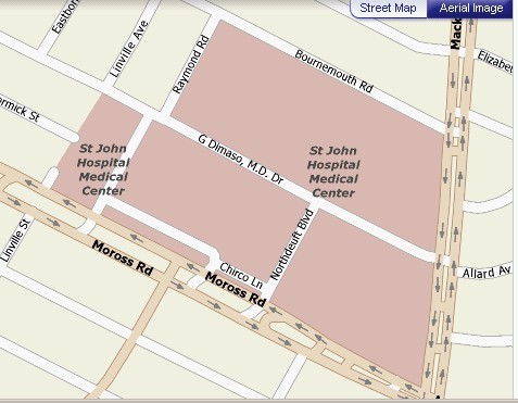
Was looking at a map of St. John's Hospital and how it's changed since little sister was born there in '60. Well, they renamed part of Kingsville, Dimaso Drive.
Would this be the same Dr. Dimaso who was a peditrician on Kelly Road? He was our peditrician; he had this "mod" decor in his waiting room for years: orange and yellow circles in the windows. Did any of you go to him?
When did they name the street for him and why? (I know he was a good doctor, but that's some honor!) |
Jaj
Member
Username: Jaj
Post Number: 5
Registered: 05-2007
| | Posted on Saturday, May 26, 2007 - 12:18 pm: | |
I see some posts mentioning some folks parents/relatives working at Chatham... does anyone remember My Mom Edna Johnston?.. she started at Chatham Village on Hayes south of Seven mile (1962) and worked at probably all the other locations for 20 years..the Weisberg family owned the stores... Kay Adams was the one who did the hiring. |
Kellyroad
Member
Username: Kellyroad
Post Number: 41
Registered: 04-2007
| | Posted on Saturday, May 26, 2007 - 12:25 pm: | |
Jaj,
I remember all the Chathams along Kelly, Morang, Whittier. Where was the Chatham Village on Hayes. What was the cross street? Eastwood, Saratoga, Faircrest??? |
Gibran
Member
Username: Gibran
Post Number: 410
Registered: 02-2007
| | Posted on Saturday, May 26, 2007 - 1:55 pm: | |
Paul owned the dive shop...what a blast..I took scuba lessons from him in 8th grade...Joe's Tick Tock..yep many a pop was purchased there. What about the meat market, shoe repair store...that little shopping center was kinda of cool. I remember one time Summer's funeral home had a wake for a MC Club and the whole street was one huge wake... |
Gistok
Member
Username: Gistok
Post Number: 4401
Registered: 08-2004
| | Posted on Saturday, May 26, 2007 - 2:01 pm: | |
Chathams stores were named after Chatham Village, which IIRC, was an earlier name for Harper Woods. The first Chatham (#1) was a small store located on the east side of Kelley between Moross & 8 Mile. I believe it is a Vegas Mkt. or something like that today, in a much modified building.
Chatham #2 was located over on Hayes (near where Kelley empties into Hayes).
I don't remember where Chatham #3-6 were... but Chatham #7 was located at 8 Mile & Gratiot, and Chatham #8 was at Morang & Kelley.
Eastsidedame, what part of Kingsville are you talking about? The residential stretch that is the border between Detroit and Harper Woods, or the part behind St. Johns Hospital (if it still exists at all with the new $180 million addition).
On another note, some side streets along Mack between Detroit and the Grosse Pointes change names, while others don't. Examples, University and Neff keep their same names on both sides of Mack. But some streets (in the Pointes) such as Kirby and Rivard change names when they cross into Detroit... as Gateshead and Marseilles.
The reason for the name changes is that there already is a Kirby and Rivard in and near midtown in Detroit. So they cannot use the same name (for 2 different streets) twice within the same city. |
Maxcarey
Member
Username: Maxcarey
Post Number: 102
Registered: 07-2006
| | Posted on Saturday, May 26, 2007 - 7:28 pm: | |
There was a Chatham in St. Clair Shores at approximately 9 Mile Road and Mack as well. |
Tarkus
Member
Username: Tarkus
Post Number: 331
Registered: 04-2006
| | Posted on Saturday, May 26, 2007 - 7:30 pm: | |
Wasn't the Chatham in SCS connected to Kmarts. When Chatham went under Kmart knocked down the walls and expanded. |
Kellyroad
Member
Username: Kellyroad
Post Number: 44
Registered: 04-2007
| | Posted on Sunday, May 27, 2007 - 9:35 am: | |
Gistok,
Wasn't the very fist Chatham on Kelly just south of Kenosha (south of where Tringali's bakery use to be) It was a much smaller building that emphasized produce (somewhat like Pollas use to). I believe the building was converted into a banquet hall. Later Chathams had the building a few blocks north on Kelly near Old Homestead street just the other side of the National Bank of Detroit. That building later became Vegas and then a video store. My neighbor was a manager for the Chathams and I believe he said that Chathams (by Old Homestead) was the second store. I do recall my parents saying Chathams had the best prices. |
Maxcarey
Member
Username: Maxcarey
Post Number: 103
Registered: 07-2006
| | Posted on Sunday, May 27, 2007 - 10:31 am: | |
Tarkus, I think that was a Kresge's that was connected to the Kmart.
The Chatham is now a ACE Hardware store a couple blocks south of 9 Mile on Mack. |
Whithorn11446
Member
Username: Whithorn11446
Post Number: 93
Registered: 03-2007
| | Posted on Sunday, May 27, 2007 - 12:52 pm: | |
"Another neighborhood I lived in at Dickerson & Elmdale was a nightmare to non-natives. If you look at a map, you can see that there are about 4 or 5 different street patterns converging in that neighborhood, depending on whether you were east or west of Chalmers, north or south of Houston-Whittier, or in the area east of City Airport west of Gratiot. And then there was Outer Drive & Gratiot which provided additional challenges of their own. It seemed that every street pattern that exists in Detroit somehow met in that neighborhood and many of the streets had to correct themselves in order to synthesize directions. No one could find their way around that area unless you had lived there a long time."
Kville,
Also their was the situation with street name changes in that area as well. For instance, Whithorn becomes Loretto east of Gratiot, Findlay-Filbert, Sanford-Jane,etc. However Glenfield, Wilfred, and Flanders remain the same on both sides of Gratiot. Also, Wilfred does not go through to Conner because of the old De La Salle football field.
Concerning the streets on funny angles that is definitely noticeable south of 6 Mile between Gunston and Gratiot. The streets that come to mind immediately are Dresden, Strasburg, Hamburg, Racine,etc. all the way over to Hickory(behind the old Ramona Lanes) and Pelkey. |
Kville
Member
Username: Kville
Post Number: 41
Registered: 04-2007
| | Posted on Monday, May 28, 2007 - 7:16 am: | |
Whithorn, My guess is that the name changes have something to do with the way the neighborhoods evolved. That section you mention around between 6 Mile & Gratiot east of City Airport was a challenge because of the way the streets ran on each side of that neighborhood. That area was apparently the place where they had to "straighten out" the conflicting street patterns on each side of the neighborhood because of the angles of Gratiot & 6 Mile in that area. |
Tarkus
Member
Username: Tarkus
Post Number: 332
Registered: 04-2006
| | Posted on Monday, May 28, 2007 - 8:50 am: | |
Maxcarey, why would Kresge be connected to Kmart. They were the same company. It was for sure a grocery store. Maybe Wrigley. |
14509glenfield
Member
Username: 14509glenfield
Post Number: 971
Registered: 05-2006
| | Posted on Monday, May 28, 2007 - 9:16 am: | |
Call it sub-let or whatever. I worked at the K-Mart Foods on Outer Drive & Sherwood for 4 years. K-Mart (retailer)....K-Mart Foods (food)...Borman Foods....alias Food Fair and later Farmer Jack's..buy-out by Kroger at sometime.
~a 1/4 mile parking lot. Chicks and Boys with "toys"....lot of tire wear @ midnight in that lot.
(Message edited by 14509glenfield on May 28, 2007) |
Maxcarey
Member
Username: Maxcarey
Post Number: 104
Registered: 07-2006
| | Posted on Monday, May 28, 2007 - 10:52 am: | |
Correction on my part. It indeed was a Wrigley's next to the Kmart at 9 and Harper.
Chatham was at 9 and Mack, it later became a Food Cents, I think and then the hardware store. |
Jaj
Member
Username: Jaj
Post Number: 7
Registered: 05-2007
| | Posted on Tuesday, May 29, 2007 - 6:29 pm: | |
Gistok: Thanks for remembering the Chatham Village on Hayes... somehow I remembered it as being about 2-3blocks south of 7 mile on the eastside of Hayes. My mom worked mostly at the eastside Chathams,and finally at 15/ Gratiot (Regional Shopping Ctr.)... Chatham had their offices on 10 mile near Dequindre.. |
Kellyroad
Member
Username: Kellyroad
Post Number: 49
Registered: 04-2007
| | Posted on Tuesday, May 29, 2007 - 10:38 pm: | |
Gistok or Jaj,
I remember the carwash at Eastwood and Hayes and just south of it was Bono's pizza. Don't recall Chatham's. What years are your referring to concerning Chatham's? |
Eastsidedame
Member
Username: Eastsidedame
Post Number: 165
Registered: 12-2006
| | Posted on Wednesday, May 30, 2007 - 12:57 am: | |
Gistok:
Is this map accurate?
|
Karen8824
Member
Username: Karen8824
Post Number: 4
Registered: 08-2006
| | Posted on Saturday, June 02, 2007 - 10:48 am: | |
I lived on Eastwood 7/Kelly. Worked at Silver Dragon... hung out at Heilman's in the late 70's. Went to st. jude till 1976, then to Regina. My boyfiend after high school was in the band Limousine. Had great times on the EastSide!
I live in Georgia now.... |
Gistok
Member
Username: Gistok
Post Number: 4455
Registered: 08-2004
| | Posted on Saturday, June 02, 2007 - 2:20 pm: | |
The map is partly in error Eastsidedame, It looks like the G. Dimaso Dr. continues northwestward. It does not. The only entrance to the hospital complex is from Moross or Mack (as well as a rear entrance on Bournemouth for parking for other retail along Mack).
That G. Dimaso Dr. is only named that within the hospital complex, and the street actually curves southwestward towards the north Moross Rd. medical center entrance, thus Dimaso follows an "L" shaped route.
Kingsville is the name of the street just beyond McCormick. Kingsville & part of G. Dimaso MD Dr. are the border between Detroit and Harper Woods/Grosse Pointe Woods, but they do not touch each other (like the map shows). There is a tall brick wall (hospital perimeter wall) separating them.
And on the map where the word "Dimaso" is, that is the spot where the new 7 story $180 million expansion of the hospital is located. So I don't know what the future layout of the roadway will look like.
Also since the new $180 Million expansion wing sits on the border, it is partly in Grosse Pointe Woods, and mostly in Detroit. |
Chalu64
Member
Username: Chalu64
Post Number: 195
Registered: 08-2005
| | Posted on Saturday, June 02, 2007 - 9:19 pm: | |
Dr. Dimaso was my doctor. What a great pediatrician. RIP, doc. |
Goblue
Member
Username: Goblue
Post Number: 33
Registered: 03-2007
| | Posted on Monday, June 04, 2007 - 10:44 pm: | |
In the early '60's my first wife and I lived in an apartment complex just west of St. John's on Kingsville...later, in the 80's my parents owned a condo in the same complex...my sister taught at Marquette Elementary until she retired...I left Detroit in the late '60's to follow my career across the country. |
Eastside61
Member
Username: Eastside61
Post Number: 34
Registered: 07-2006
| | Posted on Tuesday, June 05, 2007 - 1:18 am: | |
Go Blue. I have quit my job as I continue to figure out the name of the fox...... |
Newport1128
Member
Username: Newport1128
Post Number: 34
Registered: 05-2007
| | Posted on Tuesday, June 05, 2007 - 3:26 pm: | |
Anybody remember Blazo's restaurant on Mack near Moross? The AAA office is there now. When I was in high school (St. Ambrose), we used to go there after football games. |
Ron_saad
Member
Username: Ron_saad
Post Number: 101
Registered: 03-2005
| | Posted on Tuesday, June 05, 2007 - 3:59 pm: | |
I Do.
Remember knock knock street? |
Kathleen
Member
Username: Kathleen
Post Number: 2325
Registered: 10-2003
| | Posted on Tuesday, June 05, 2007 - 4:03 pm: | |
Which one? I know that there were several streets by that name on the east side. |
Goblue
Member
Username: Goblue
Post Number: 34
Registered: 03-2007
| | Posted on Tuesday, June 05, 2007 - 5:31 pm: | |
Eastside61...one of these days we'll get her name figured out! Somebody has to know who she is. Are you retiring? Wondered if the bridge collapse made life difficult for you. |
Kville
Member
Username: Kville
Post Number: 55
Registered: 04-2007
| | Posted on Wednesday, June 06, 2007 - 4:35 am: | |
Newport - I remember Blazo's. I also remember that before that, there used to be a discount store & a drug store on that site. My parents had a hardware store about 2 blocks away. I don't remember the original discount store name, but for a while they renamed it Marx Bros. and when it had its grand opening, they had a Groucho Marx impersonator there with the odd mustache, cigar, etc. (pretty wild for Grosse Pointe, eh?). Later, they tore the discount store down, leaving only the drug store forming a long slice on the corner of Bournemouth. If I remember correctly, when the drug store came down to build Blazo's, it was the same one that moved into the next block and became Woods Pharmacy (later Merit-Woods). |
Ron_saad
Member
Username: Ron_saad
Post Number: 103
Registered: 03-2005
| | Posted on Wednesday, June 06, 2007 - 7:10 am: | |
It was Morningside drive in Grosse Pointe.(Knock Knock Street) Remember the little house in Detroit where the little elfs lived? |
Kellyroad
Member
Username: Kellyroad
Post Number: 67
Registered: 04-2007
| | Posted on Thursday, June 07, 2007 - 1:32 am: | |
Ron Saad,
Give this former eastsider some info. What does the term knock knock street come from? |
Kathleen
Member
Username: Kathleen
Post Number: 2328
Registered: 10-2003
| | Posted on Thursday, June 07, 2007 - 5:44 am: | |
Kellyroad: The urban legend of "knock knock" street or road is pretty well known around the country. The one in Detroit that I always heard of was Strasbourg Street below 7 Mile Rd. over near Osborn High School. I'm sure that there are others around the metro area.
Basically the story is "that a girl was playing in the street and was killed when a car hit her. Ever since her death, if you drive down that street someone or something knocks loudly on the undercarriage of your car." |
Kellyroad
Member
Username: Kellyroad
Post Number: 68
Registered: 04-2007
| | Posted on Thursday, June 07, 2007 - 10:32 am: | |
Kathleen,
Thanks for the info. The irony...our family has relatives who lived on Strasbourg near 7 Mi. |
Joymac
Member
Username: Joymac
Post Number: 2
Registered: 06-2007
| | Posted on Thursday, June 07, 2007 - 12:58 pm: | |
I am a true eastsider. I grew up on Lenox, below jefferson. At that time the Ford's lived in the mansion that the Hari Krisnta's live in now. St.Martins Catholic church was across the street. That was the Catholic school of choice until it closed and everyone either got bused out to public schools or to St. Ambrose. Garwood mansion was still standing, where Garwood condos are now.
Lakewood park was a safe park at the time.Not sure now. We use to ice skate in the canal across the street and collect garner snakes when the field caught on fire. Lot's of memories. Even when the riots happened. Seeing tanks come down the street, not being able to leave the house. I now live on Bishop in EEV with my husband - the 4000 block. Sounds like many of my neighbors are connected! Look forward to sharing more east side stories! |
Joymac
Member
Username: Joymac
Post Number: 3
Registered: 06-2007
| | Posted on Thursday, June 07, 2007 - 12:59 pm: | |
oh and yes, Ron's hair piece is a hoot! Yorkshire has a great meat counter though! |
Pgn421
Member
Username: Pgn421
Post Number: 81
Registered: 02-2005
| | Posted on Friday, June 08, 2007 - 6:47 am: | |
JoyMac-40 years on Bishop! Off Mack |
Joymac
Member
Username: Joymac
Post Number: 5
Registered: 06-2007
| | Posted on Friday, June 08, 2007 - 12:21 pm: | |
Hi neighbor Pgn421! Do you still like living there? |
Joymac
Member
Username: Joymac
Post Number: 6
Registered: 06-2007
| | Posted on Friday, June 08, 2007 - 12:24 pm: | |
oh sorry, you had lived there Pgn421 |
Pgn421
Member
Username: Pgn421
Post Number: 82
Registered: 02-2005
| | Posted on Friday, June 08, 2007 - 2:55 pm: | |
parents passed sold the house. they bought it for 25k, i got 139k. |
Goblue
Member
Username: Goblue
Post Number: 41
Registered: 03-2007
| | Posted on Saturday, June 09, 2007 - 3:54 pm: | |
My parents bought their house on Fordham for $2K in 1936...they sold it for $11K in 1971 when they moved to a condo in Harper Wds. Sometime in the 90's it was torched. What a mess that neighborhood has become! |
Eastside61
Member
Username: Eastside61
Post Number: 37
Registered: 07-2006
| | Posted on Saturday, June 09, 2007 - 5:03 pm: | |
Have a friend who lived on Bishop between CP Drive and Warren in EEV and it took him over three years to finally sell it in 2005...I think there were at least 4 homes for sale just on his block alone and the house next to him had been vacant for over a year.....Go Blue I lived on Mapleridge between Morang and Salter.....Things are looking pretty bad these days.....but no one has torched 15630....YET!!!!! |
Goblue
Member
Username: Goblue
Post Number: 45
Registered: 03-2007
| | Posted on Sunday, June 10, 2007 - 11:02 pm: | |
Well hell Eastside61: Ya'll lived in the upscale side of the Eastside...as I recall the homes on Mapleridge were pretty much brick...doesn't burn as well as the frame houses on Fordham. You must be referring to Tom T's home...did you say he's living in Florida these days? |
Eastside61
Member
Username: Eastside61
Post Number: 41
Registered: 07-2006
| | Posted on Sunday, June 10, 2007 - 11:11 pm: | |
GB - He split for the Tampa / Sarasota area. Still hanging in there with the Wings and Tigers. I hear from him on a weekly basis. The Bishop sale was grueling....prior to his move to FL he sponsored the annual "Gun Fire Classic" golf outing at Chandler Park.....Interesting golfing at CP with all the abandoned homes surrounding the course...I lived on Eastwood until 8th grade.... |
Scotty00
Member
Username: Scotty00
Post Number: 6
Registered: 04-2007
| | Posted on Sunday, June 10, 2007 - 11:45 pm: | |
I grew up from '76-92 at the corner house of State Fair and Gratiot. We were the house right behind Taffy's Bar, and across from Saratoga hospital. I remember hot summer nights listening to the music from my bedroom window, and listening to drunken chatter. I remember riding my bike watching the hospital parking structure being built. Taffy's and the three houses on Tacoma were torn down to make way for hospital employee surface parking. I got used to the ambulance sirens, and didn't wake up to them.
In the 80s, I hung out at Carmen's, the Electric Palace, and held paperboy duties from the Liberal/Gratiot News station on the west side of Gratiot. I ate coney dogs at the Dog House with my paper route earnings, and got snacks from next door: Giglio's Italian Market. Anyone one remember Heisler Drugs? I had a massive blue Henze Real Estate sign on top of the building. It was around Eastburn and Gratiot, across from I believe Detroit's first Taco Bell. Hiesler's was where I picked up CarToons and Mad Magazine. It burned down in 1985. |
Goblue
Member
Username: Goblue
Post Number: 48
Registered: 03-2007
| | Posted on Monday, June 11, 2007 - 4:27 pm: | |
ES61: Where on Eastwood did you live? Our number on Fordham was 14630...between Celestine and ???...next street to the east.
I knew the Chandler Park golf course well...got a varsity letter playing for Denby in '57...CP was our home course. I dropped off the team the next year...my father was unemployed in the recession of 1958-59...he had retired from DPD and was working as a truck driver...the company went bankrupt...I had a job at Fox Portrait Studio on Gratiot just below Six Mile...family needed the money...nobody asked me to do it but I knew what needed to be done...I didn't feel bad about it at the time but I was a likely pick for All-City that year...looking back it would have been nice to have the second letter and a white stripe on my sweater. I remember telling my dad that instead of going to college I wanted to go to the pro golfers school in Florida...I couldn't even get a discussion on that one!
Good to hear that Tom T is doing well...as a little brother he used to get in the way alot when his sister and I wanted some "private" time. |
Eastside61
Member
Username: Eastside61
Post Number: 44
Registered: 07-2006
| | Posted on Monday, June 11, 2007 - 6:55 pm: | |
GB - next time I e mail TT I will mention that he found you outside their house on Farmbrook somewhere under the branches of the big blue spruce tree that was in their front yard.....CP GC was in great shape last time I played there.....but the Neighborhood around it was really looking BAD!!! in various ways.... |
Goblue
Member
Username: Goblue
Post Number: 49
Registered: 03-2007
| | Posted on Monday, June 11, 2007 - 7:52 pm: | |
ES61: You would impugn his sister's honor!! |
Eastside61
Member
Username: Eastside61
Post Number: 46
Registered: 07-2006
| | Posted on Monday, June 11, 2007 - 10:51 pm: | |
GB - So it is true....thanks |
Goblue
Member
Username: Goblue
Post Number: 52
Registered: 03-2007
| | Posted on Tuesday, June 12, 2007 - 11:19 am: | |
ES61: LOLOLOL.....not true!! However...their living room couch...and the front seat of my '56 Ford convertible were possible locations if such a thing were to have ever happened.
That really was a great old tree in front of their house wasn't it? It must have been 20-30 ft. tall. |
Turkeycall
Member
Username: Turkeycall
Post Number: 5
Registered: 09-2008
| | Posted on Monday, September 08, 2008 - 11:23 am: | |
Knock-knock Street? What about the story about Luke the Spook who was supposed to have been hanging out around 21 mile and Romeo plank?
I-94? I grew up on Farmbrook-'50-'73. My folks bought a 40-acre farm up in the Thumb in '58. I remember the freeway hole from Cadieux to 8 Mile and then the freeway going all the way to 8 Mile around '59.
We used to take Harper Avenue to catch Gratiot, then on to Richmond, then decide whether to take US-25 to Port Huron or M-19 to Yale.
Dad would get on the freeway at 7 Mile and get her up to 55, then had to get off at 8 Mile. At least he could say he went 55 mph inside the city limits! |